
Central Oklahoma hit with winds greater than 90 mph. Super Typhoon Bavi will impact the Mariana Islands in the next several hours.
Jul 05, 2026
Going to use author’s prerogative to start off this morning’s newsletter with personal weather experience. Last evening I was watching radar trends on a complex of strong to severe storms building southeast across northern Oklahoma. Early on, I was hopeful that the worst of the severe weather would slide east of our house and northeast side of Norman — but as storms continued to build west that hope waned.. By the end of this radar loop above, I knew we were in trouble — the outflow from the complex to our north was intersecting with the complex to our west, and the result would likely be a particularly intense surge of wind into Norman.
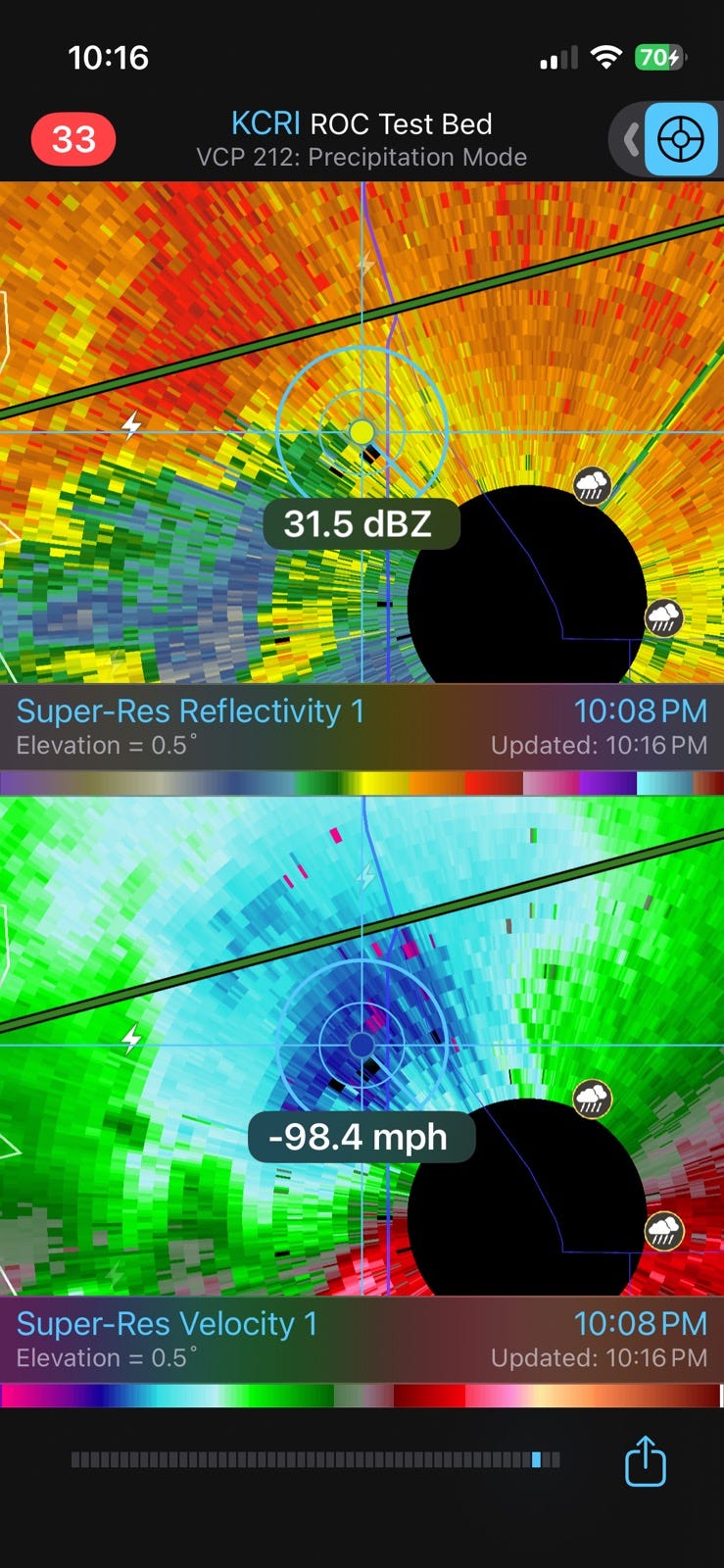
Indeed, as the storms were starting to impact Westheimer Airport and the North Base complex where NWS and NSSL test radars are operated and maintained, an impressive area of radar base velocities near 100 mph was apparent. The NWS observing site at Westheimer Airport reported a wind gust of 93 mph from the storms, and the nearby Oklahoma Mesonet site reported a wind gust of 90 mph.

We live a few miles east-northeast of North Base and I would estimate we had several surges of wind 75+ mph over a 15 minute period of high winds. We lost power for about 3 hours but luckily had minimal damage – the situation is worse to our west and through the heart of Norman where there is apparently extensive tree damage and some structural damage. There are still about 25K customers without power in the immediate area per PowerOutage.us.
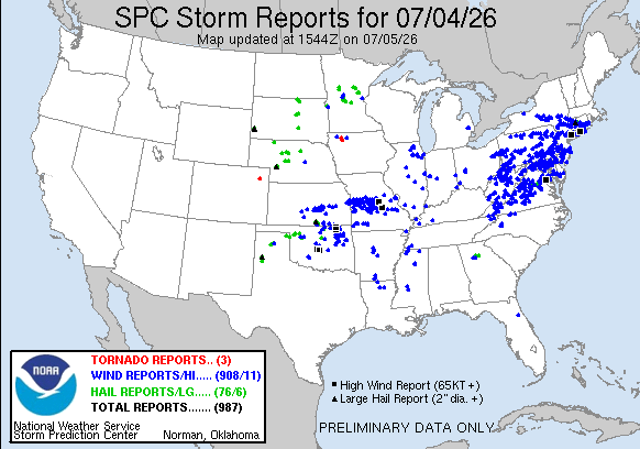
These storms were part of an incredibly busy Fourth of July with regard to severe thunderstorm activity, as nearly 1000 reports of severe weather were received by the NWS, mostly wind damage. In addition to the reports around Norman, about 10 other locations were impacted by significant measured wind gusts (75+ mph), including in northeast Oklahoma, central Missouri and parts of the Mid-Atlantic. At the peak of the storms, power was out to nearly 1.5M customers nationwide, and as of this morning nearly 1M customers are still without power from storms over the last couple of days. Michigan, Pennsylvania and New Jersey are the hardest hit states. Connecticut was also impacted by some particularly intense storms — in addition to 75K customers still without power, hail slightly larger than baseballs fell in the area around Bristol (home of ESPN).
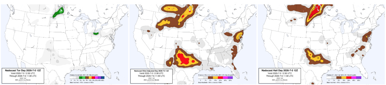
Today is expected to be a bit less active, but with three main areas of focus for severe activity: the Mid-Atlantic, the Southern Plains, and far Northern Plains.
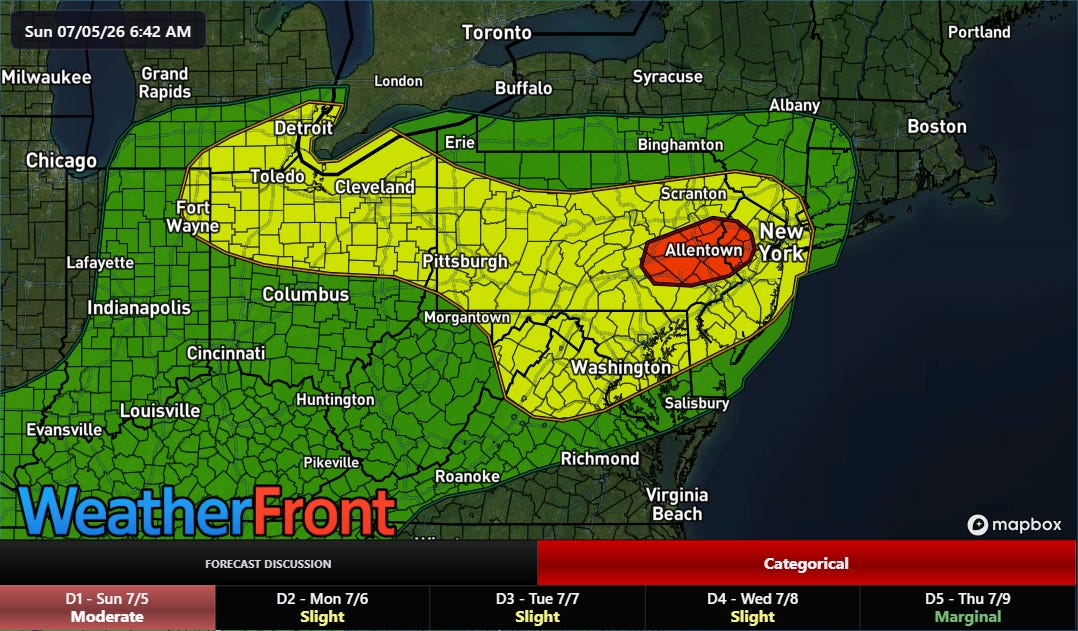
Perhaps the greater concern for thunderstorms today is flash flooding, with a focused moderate (level 3 of 4) risk of flash flooding across parts of New Jersey and eastern Pennsylvania within a broader slight (level 2 of 4) risk. The Weather Prediction Center noted that this morning’s upper air balloon data showed near record levels of moisture at Pittsburgh, Washington, and New York City — and as atmospheric forcing for thunderstorm development increases this afternoon and evening, some significant pockets of intense rainfall and flash flooding could develop.
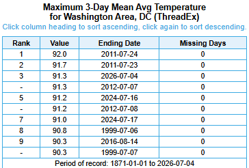
Turning to the heat, the official observing site for Washington at Reagan National airport set an Independence Day record high of 103F. The average temperature over the last 3 days tied for the third highest on record — interesting to note that all of the top 10 hottest days by average temperature in DC have been since 1999. Atlantic City set a new all-time record maximum temperature yesterday with 106F, and its 3 day average max temperature of 104.7 is hottest on record. It was the third hottest 3 day period based on average temperature.
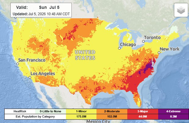
Today will continue to see the heat gradually wane across the East, with the main focus across Virginia and the Carolinas where extreme heat risk will continue as temperatures should make the century mark in many locations.
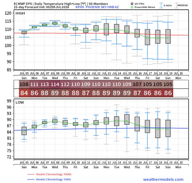
Above normal temperatures and humidity will continue to linger in the Southeast this week, while a new wave of heat will build in the West, starting initially in the Desert Southwest where Phoenix looks to be facing its first prolonged period of temperatures near or above 110F. Extreme heat watches are in effect for this region.
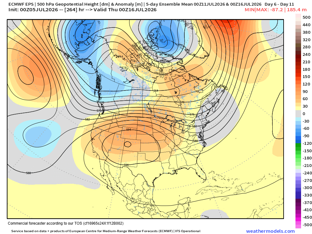
This initial surge of heat looks to be the vanguard of what could be a potentially prolonged major heatwave for much of the western half of the nation starting late this week and continuing into next week. The longer range models are in good agreement on an unusually large and strong dome of upper level high pressure building across this region and continuing for many days. This could mean several days of record or near record heat for locations like Denver and Salt Lake City — and some locations could set all-time records depending on the ultimate exact strength and location of the intense high pressure center.
Last but certainly not least, I want to talk about Super Typhoon Bavi which radar and satellite data shows has intensified again in the last 12 hours, with the Joint Typhoon Warning Center now estimating its maximum sustained winds at 180 mph, a category 5 on the Saffir-Simpson Hurricane Wind Scale. Bavi is moving generally west-northwest about 14 mph, and is expected to directly impact the island of Rota (population ~2K) over the next several hours, where NWS Guam warns of potentially catastrophic wind damage. Guam will be on the “weaker” left side of the storm, while Tinian and Saipan to the north will be on the stronger right side and should see at least SSHWS category 1 strength winds.
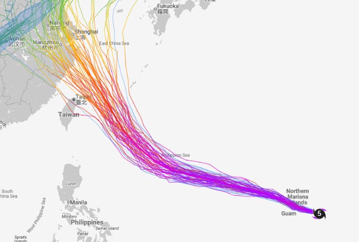
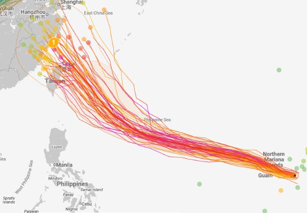
After passing through the Marianas, Bavi is expected to remain a powerful super typhoon for the next few days as it moves west-northwest. Eventually, the models suggest it may pose a threat to Taiwan or mainland China in about 5-7 days.


Leave a Reply