
Pacific remains very active with Simon expected to make landfall in Mexico as a category 4 hurricane and Rachel threatening impacts for Baja California and the Southwest US
4 minutes ago
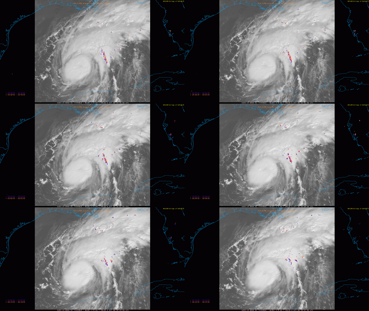
Isaias has continued to intensify rapidly over the last 24 hours, going from a minimal tropical storm yesterday morning to an 85 mph hurricane this morning. When it became a hurricane late last evening, it became the first hurricane of the 2026 Atlantic tropical season — the latest by far in the most reliable climatological dataset we have since satellites were launched in the 1960s.
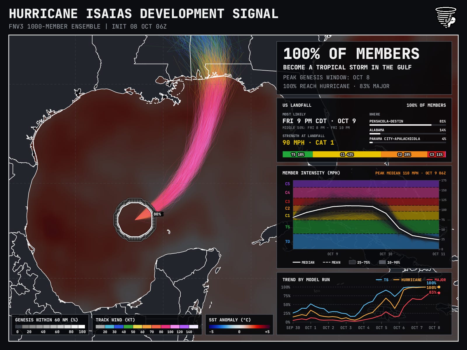
All signs are that Isaias is continuing to intensify. NHC noted in their morning discussion that microwave satellite data was showing signs of a building ring of thunderstorms around the center indicative of rapid intensification, reconnaissance data shows the central pressure is down to just below 975 millibars, and there are signs in visible satellite imagery that an eye is starting to form. Nearly all of the 1000 member Google DeepMind (GDM) ensemble show Isaias making major hurricane status at some point in its track over the Gulf as do the regional hurricane specific dynamical models. Given that, it certainly will not be surprising if Isaias makes category 3 or higher intensity even though NHC currently has it peaking out a high end 2 on the Saffir-Simpson Hurricane Wind Scale (SSHWS).
![[Key Messages]](https://substackcdn.com/image/fetch/$s_!qKSo!,f_auto,q_auto:good,fl_progressive:steep/https%3A%2F%2Fsubstack-post-media.s3.amazonaws.com%2Fpublic%2Fimages%2F1506df7b-2b36-47b4-a3cd-879e5a04afcb_897x736.png "[Key Messages]")
The other models continue to trend toward the faster, farther east scenario that has been indicated by the GDM AI system, with landfall likely to occur Friday night somewhere between Destin and Pensacola. The hurricane will likely be entering a weakening phase at some point prior to or around landfall due to increasing shear and drier air. The timing and rapidity of that weakening though is very difficult to forecast, and as of now the expectation is that Isaias will remain a significant hurricane as it makes landfall and moves rapidly inland to the north and northwest.
There is a concern for significant, widespread and potentially prolonged power outages along the track of Isaias in areas where tropical storm and hurricane warnings are in effect. Life-threatening storm surge of up to 7 feet is also anticipated near and to the east of where the eye makes landfall.
![[Image of WPC Flash Flooding/Excessive Rainfall Outlook]](https://substackcdn.com/image/fetch/$s_!4LqF!,f_auto,q_auto:good,fl_progressive:steep/https%3A%2F%2Fsubstack-post-media.s3.amazonaws.com%2Fpublic%2Fimages%2F7ffe5b95-08dc-4614-9f63-f2caab861001_893x746.gif "[Image of WPC Flash Flooding/Excessive Rainfall Outlook]")
While the rapid movement of Isaias should keep rainfall from becoming too extreme, there is certainly a risk of flash flooding from the landfalling system — particularly where rainbands train on the eastern side of the center and along and just west of the eye where torrential rainfall will occur for several hours.
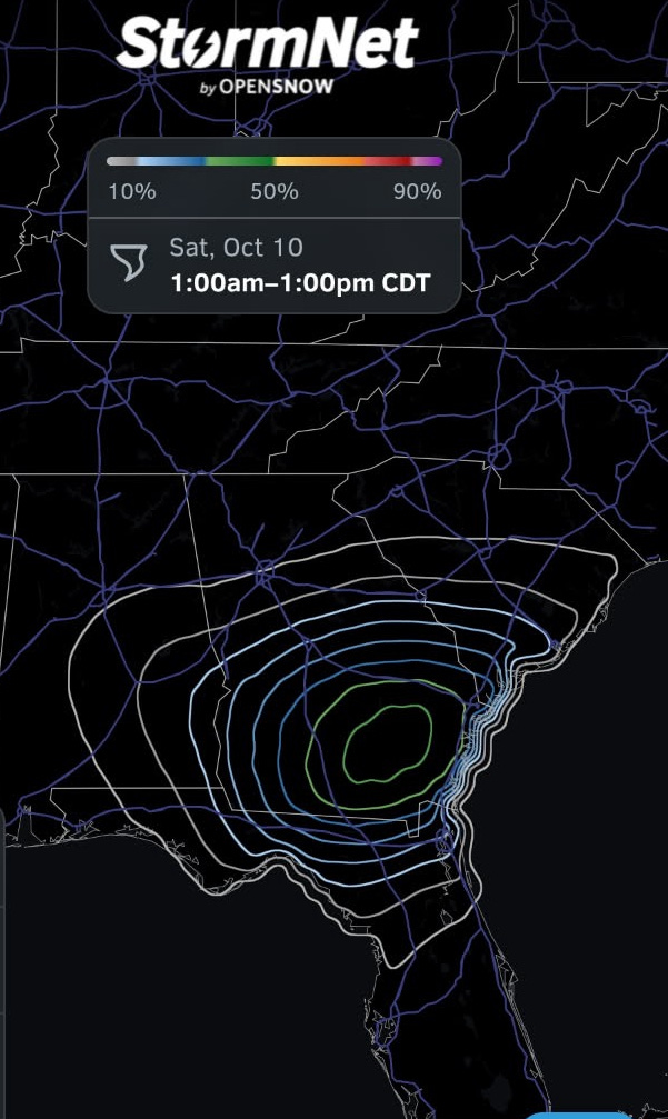
Tornadoes are a concern with any landfalling tropical cyclone, and the setup with Isaias looks as if it may be particularly conducive to the threat of tornadoes within the storms and rainbands on the east side of the center. The maximum risk should initially be in the Florida Panhandle Friday night and shift to include Georgia, eastern Alabama and parts of South Carolina on Saturday.
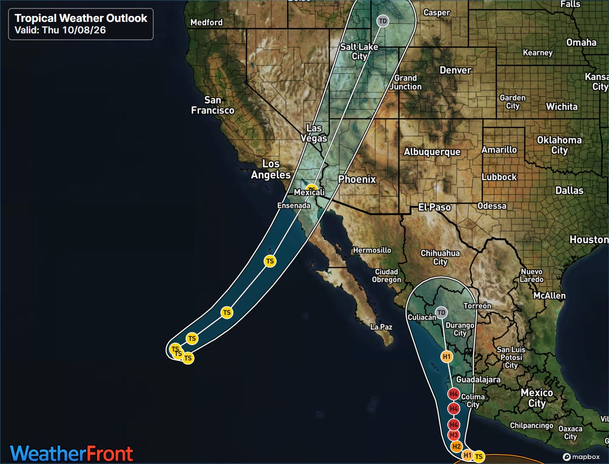
Unfortunately, the Pacific has not gotten any quieter with Isaias in the Gulf of Mexico. A tropical disturbance southwest of Mexico developed into Tropical Storm Simon yesterday, and is expected to rapidly intensify as it moves toward the west coast of Mexico the next few days. Meanwhile, Rachel weakened to a strong tropical storm over the last 24 hours — while it will continue to gradually weaken, it is about to take a sharp turn toward the northeast and toward the southern California/Baja California Norte border region.
![[Key Messages]](https://substackcdn.com/image/fetch/$s_!ViQB!,f_auto,q_auto:good,fl_progressive:steep/https%3A%2F%2Fsubstack-post-media.s3.amazonaws.com%2Fpublic%2Fimages%2Fd25e4b52-f9c8-4a94-bf8b-d0627f6927f5_897x736.png "[Key Messages]")
Simon looks poised to bring serious impacts to the west-central coast of Mexico this weekend, with NHC forecast it to be a category 4 hurricane on the SSHWS at landfall late Saturday. Major storm surge, wind damage and life threatening flash floods and mudslides are all likely.
![[Key Messages]](https://substackcdn.com/image/fetch/$s_!m1ao!,f_auto,q_auto:good,fl_progressive:steep/https%3A%2F%2Fsubstack-post-media.s3.amazonaws.com%2Fpublic%2Fimages%2Fec6c2491-3290-47cc-8eb5-09b82ffea837_897x736.png "[Key Messages]")
Rachel is currently weakening due to drier air and cooler sea surface temperatures. However, as it turns northeast back toward the coast, it will be encountering unusually warm (for the region) SSTs that will be marginally sufficient to support a tropical cyclone. Additionally, the strong upper level trough that will be picking up Rachel will likely add some dynamic support to the system — some models actually show the low pressure center with Rachel strengthening a bit as it approaches the coast. So while it is unclear whether Rachel will be tropical or not, the low pressure center should bring some strong winds and heavy rainfall to the region of Southern California and Baja California Norte this weekend.
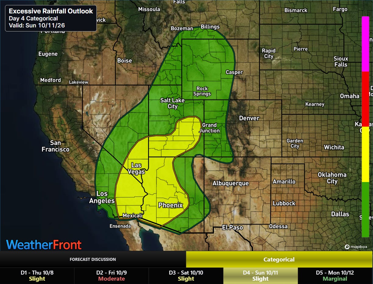
Tropical moisture will stream northeast well ahead of the low center, supporting showers and storms with heavy rainfall that could produce flash flooding, particularly late Saturday into Sunday.
I will be providing occasional updates about all of this between newsletters via social media and Substack Notes. We had a Substack Chat for paid subscribers yesterday where I posted occasional updates and had some great questions from subscribers — today’s chat room is now open here.


Leave a comment