
Rachel and Simon to cause serious impacts this weekend on the Pacific side
6 minutes ago
Isaias continued to intensify overnight, and as I discussed as a high possibility yesterday it became a major hurricane early this morning with maximum sustained winds of 120 mph and a minimum central pressure of 959 millibars. Reconnaissance, radar and satellite data suggests that the hurricane has peaked in intensity, and most guidance suggests some weakening over the next several hours prior to landfall as shear increases. However, the speed with which this weakening will happen is quite uncertain, and NHC is now showing it as a major hurricane just before landfall somewhere between Pensacola and Destin this evening.
![[Key Messages]](https://substackcdn.com/image/fetch/$s_!CkcH!,f_auto,q_auto:good,fl_progressive:steep/https%3A%2F%2Fsubstack-post-media.s3.amazonaws.com%2Fpublic%2Fimages%2Ff3bf901e-cd3a-4b15-a8f9-aa51a4871eda_897x736.png "[Key Messages]")
Forecast peak storm surge values have increased a bit — dangerous, life-threatening surge of up to 9 feet above ground level are expected near and east of where the eye crosses the coast as far east as Grayton Beach.
Even though the hurricane will be weakening fairly quickly once it makes landfall, the rapid motion of the storm will mean that strong wind gusts will spread well inland. With this hurricane interacting with the strong jet stream to the north, winds will likely be quite strong even to the west of the eye. Given the extensive pine trees in this part of the country, widespread, long duration power outages are a significant concern. The fast forward motion should limit more extreme rainfall totals, but flash flooding is still a concern along and just west of the eye — and as rain bands train to the east of the storm. Rain bands coming in off the Atlantic along the Georgia and South Carolina coast should be a concern for flash flooding as well. While it is a deterministic model forecast and should not be taken verbatim, this loop of wind gusts and rainfall totals through midnight tonight should be illustrative of the general progression of impacts.
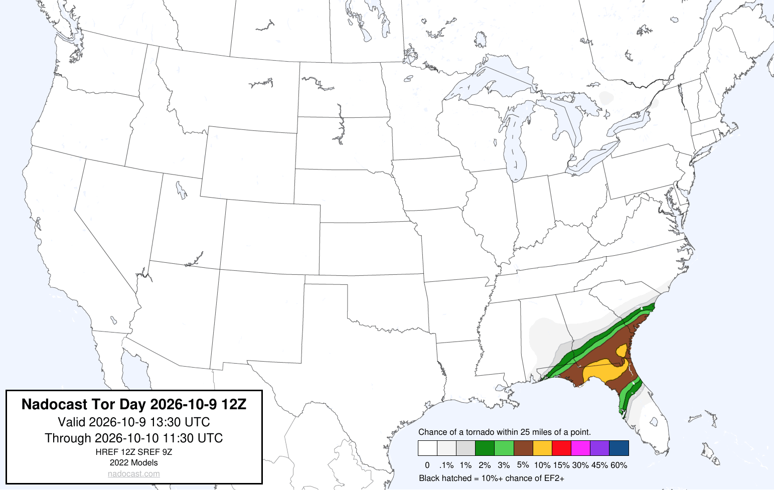
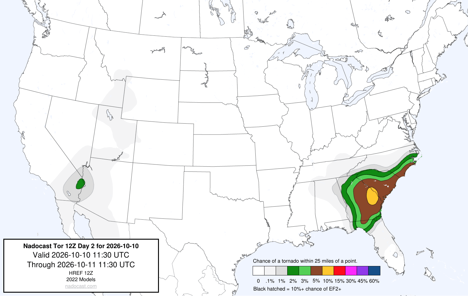
As we discussed yesterday, the threat of tornadoes with Isaias looks greater than normal given the high atmospheric shear and drier air in the middle levels of the atmosphere over the Southeast, both conditions which favor a greater tornado risk with landfalling tropical cyclones. The risk should increase across the Florida Panhandle later today, and spread north and northeast across Georgia and into coastal North Carolina through Saturday.
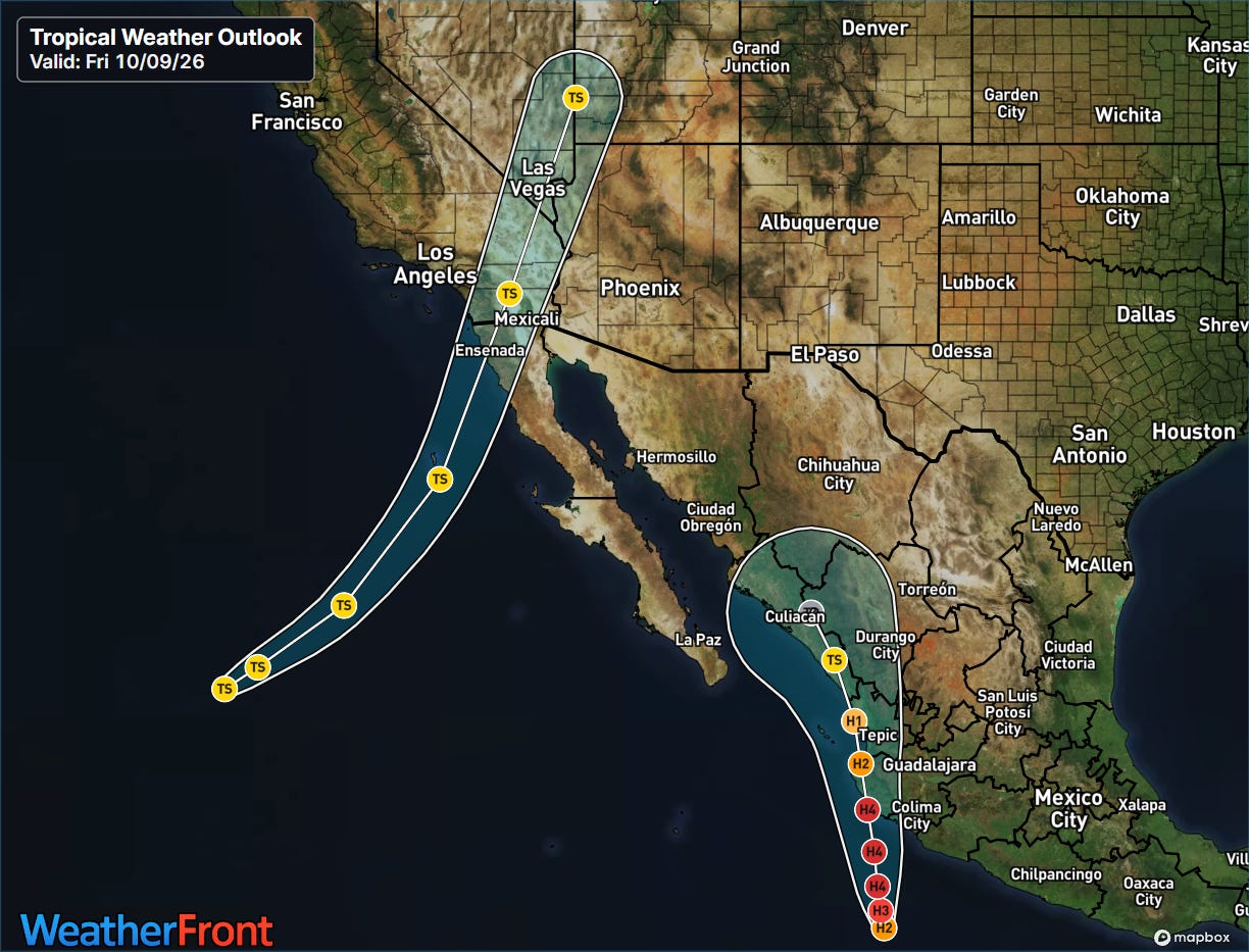
Isaias is the most imminent concern today, but significant tropical impacts are expected in the Pacific this weekend. Rachel has weakened to a 50 mph tropical storm, but has now turned northeast and is moving toward northern Baja California. As we have been talking about, the combination of atmospheric dynamics from the strong upper level trough of low pressure developing along the West Coast and unusually warm sea surface temperatures in the region will likely allow Rachel to remain a tropical storm until it makes landfall late Saturday.
![[Key Messages]](https://substackcdn.com/image/fetch/$s_!1hl3!,f_auto,q_auto:good,fl_progressive:steep/https%3A%2F%2Fsubstack-post-media.s3.amazonaws.com%2Fpublic%2Fimages%2F79bec496-855c-4d8e-977f-8d7b4eb1220c_897x736.png "[Key Messages]")
Strong wind gusts and heavy rainfall with flash flooding are anticipated along the path of Rachel as it moves across northern Baja and into southern California and Arizona. A tropical storm watch is now in effect from northern Baja California along the southern California coast as far north as the San Diego/Orange county line. Swells have been impacting coastal areas of Southern California and Baja from Rachel, and these will continue as the storm approaches, causing coastal flooding, heavy surf and rip currents.
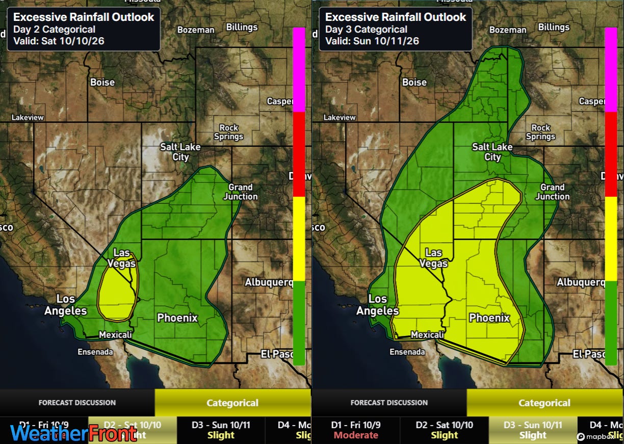
Moisture will spread northeast well ahead of the center of Rachel, supporting showers and storms with heavy rainfall which will cause incidences of flash flooding.
![[Key Messages]](https://substackcdn.com/image/fetch/$s_!l5Xw!,f_auto,q_auto:good,fl_progressive:steep/https%3A%2F%2Fsubstack-post-media.s3.amazonaws.com%2Fpublic%2Fimages%2F0a07ece1-9e30-40e3-8a1e-84687e2fa7d6_897x736.png "[Key Messages]")
Hurricane Simon is expected to continue a rapid intensification process through Saturday, and will be moving along the western coast of Mexico as an anticipated category 4 hurricane. The center of the storm will be moving north-northwest oriented to the coast — so the intensity of the hurricane as it moves farther up the coast will be highly dependent upon whether the core actually moves inland or stays just offshore. Regardless, major to catastrophic storm surge, flash flooding and wind impacts are expected in western coastal Mexico over the weekend.
I will be providing occasional updates about all of this between newsletters via social media and Substack Notes. I will also be hosting a Substack chat for paid subscribers to post info as I see things and answer questions — today’s chat room is now open here.


Leave a Reply