
Plus: are we on the verge of an AI revolution in meteorology?
8 minutes ago
Happy Friday! I want start today by highlighting and discussing an important post from another great Substack I follow. My colleague Michael Lowry put together an excellent summary in his newsletter this morning of the forecast model performance for Hurricane Isaias, based on the analyses of former NHC Science and Operations Officer Dr. Wallace Hogsett and retired NHC forecast branch chief James Franklin. While the AI models are still a mixed bag as far as intensity and genesis forecasts, it is clear that they are now the superior guidance when it comes to forecast track — and that the Google DeepMind (GDM) is far and away the best track guidance as well as a significant leap forward on intensity forecasts.
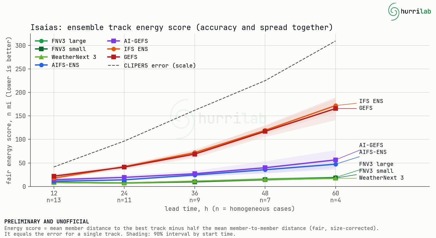
This graphic from Dr. Hogsett and shared by Michael is a plot of “energy score” — a verification parameter that combines track accuracy and consistency — and shows that GDM was by far the best forecast guidance at all time periods. AI guidance from the European AI ensemble and the US Global Ensemble Forecast System was next best though less accurate — and the physical based global models were significantly worse. As Dr. Lowry summarized in his post:
One of the wrinkles we discussed early on in Isaias’ forecast were the differences across models in both where and when Isaias would hit the northern Gulf. The traditional, physics-based modeling systems favored a weaker, slower-moving storm striking farther west (closer to Louisiana or coastal Mississippi). The AI models, on the other hand, leaned east (closer to coastal Alabama or the Florida panhandle) and advertised a stronger, quicker-moving storm through landfall.
Not surprisingly, the AI models also outshone the physics-based models in predicting the timing and location of Isaias’ landfall. Most impressively, Google DeepMind pinpointed landfall to within a few hours three days out while also being closest to where the actual center made landfall at Destin, Florida. The physics-based Euro and GFS ensemble systems were not only too far west on landfall but too late on landfall by a full 24 hours or more. Missing the timing of landfall can put lives at risk for those preparing for or evacuating from threatening hurricanes so this was another huge success story for the AI hurricane models during Isaias.
Without the AI guidance, there is almost no question that the NHC forecast would have had to rely much more heavily on the physics based models, and been too slow, too far west and potentially not strong enough. It seems clear that the AI guidance had a significant positive impact on the forecast that had tangible societal and economic impact by allowing officials to target the correct areas for evacuations and preparation — and not needlessly evacuate people who ended up not being at risk.
I will have more to say about all of this in a coming newsletter, but from talking to colleagues in the wake of Isaias, it feels to me like Isaias may one day be looked at as a watershed moment where AI meteorological guidance hit the mainstream of the weather community and society in general. While there is a lot of (deserved) scrutiny about AI and its broader societal impacts, as I have discussed before meteorological problems seem particularly well suited to AI approaches. The incredible success of GDM for hurricane forecasting in such a short period of time — and extremely promising AI approaches to other weather phenomena such as Nadocast and NSSL’s Tornado Probability Algorithm — suggest that we are truly on the cusp of a revolutionary period in meteorology in which AI will not only change how we forecast and warn for weather events, but likely how and why we observe the atmosphere.
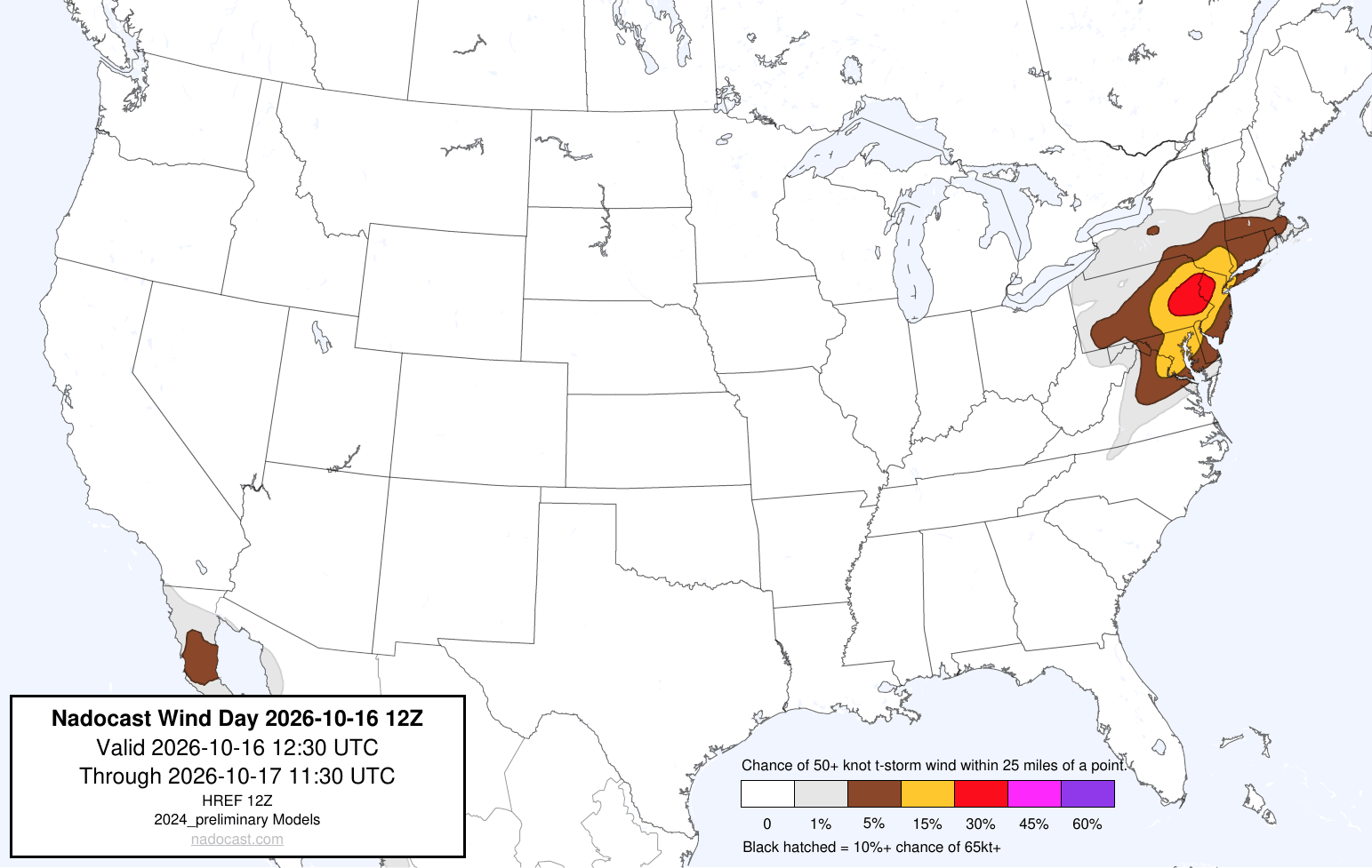
Speaking of Nadocast, today’s forecast is highlighting a potential for severe storms with damaging winds across the Mid-Atlantic as a cold front moves into the warm and humid airmass across the region.
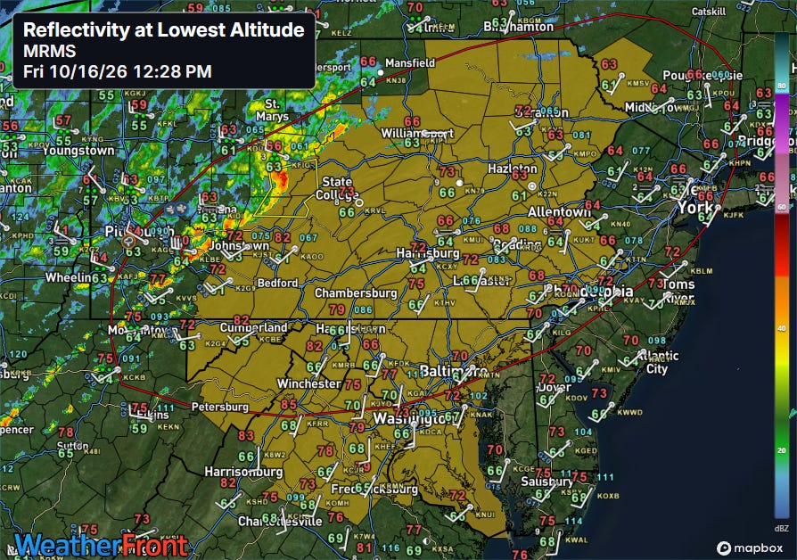
A band of strong to severe storms is already evolving along the cold front, and a severe thunderstorm watch (orange area) has been issued by the NWS Storm Prediction Center ahead of this line of storms which will move east this afternoon and evening.
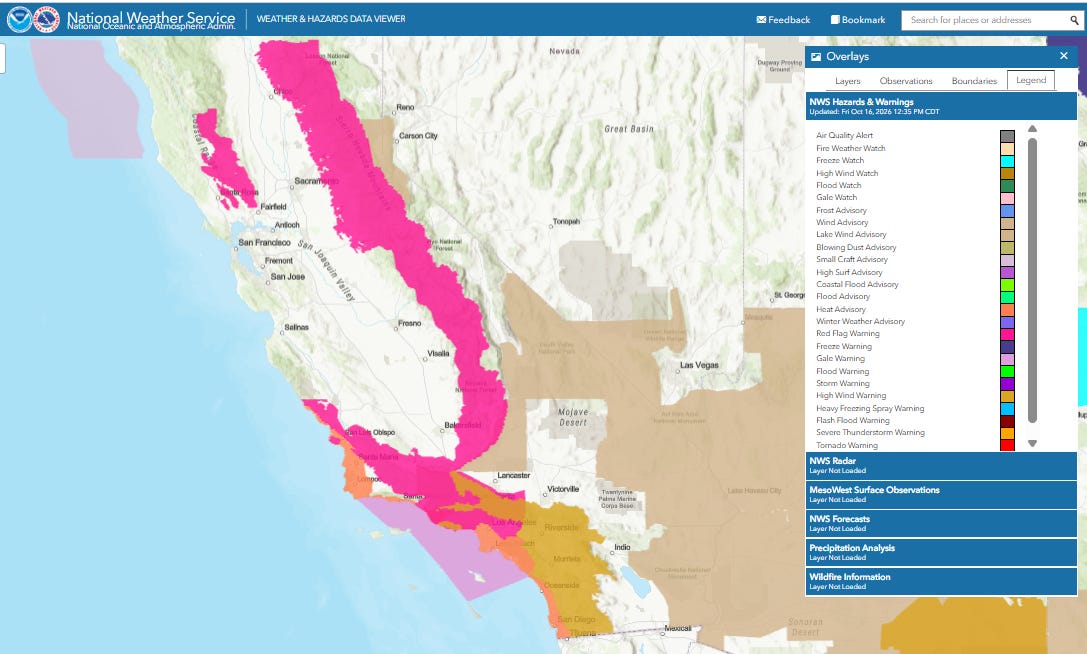
Out west, hot and dry Santa Ana winds have been fueling wildfires in California, with evacuations reported and tens of thousands without power due to safety shutoffs. Red Flag Warnings (pink areas) are in effect for many areas.
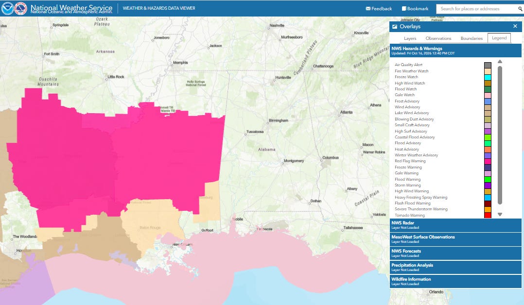
Red Flag Warnings are also in effect for portions of the Arklatex and Arklamiss into the central Gulf Coast where ongoing drought and dry, strong northerly winds could support rapid growth and spread of wildfires this afternoon.
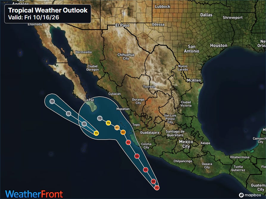
In the tropics, Simon (farther northwest system) continues to spin down and should weaken to a depression soon, while Trudy has become a major hurricane is expected to intensify into a category 4 hurricane and potentially impact parts of Pacific coast of Mexico west of Guadalajara this weekend.
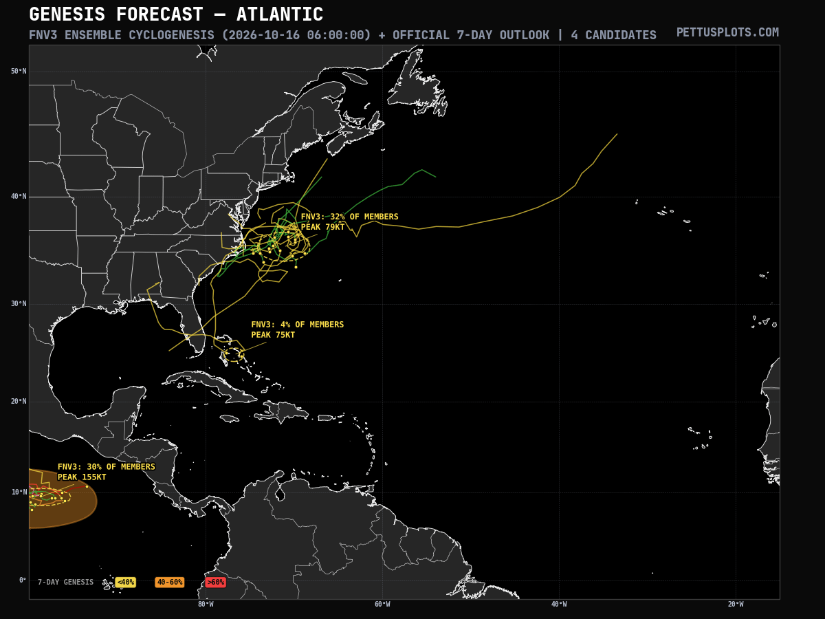
In the Atlantic, the models continue to suggest the potential for a tropical or subtropical system off the Mid-Atlantic coast next week. As this graphic from PettusPlots.com shows, about a third of the GDM ensemble members show a tropical system developing.
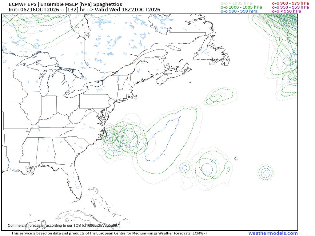
Regardless of whether it is tropical, the overall pattern suggests a storm system should develop in the western Atlantic by the middle of next week as shown by the physics-based European ensemble. The track, intensity and nature of it have a lot of uncertainty — so we will be watching the forecast evolution closely for any potential impacts to the East Coast.


Leave a Reply