
Raises concerns about potential gaps in coverage and diminishing capabilities, including loss of lightning mapping
9 minutes ago
Back in August 2025, I wrote a post about talking about NOAA’s geostationary satellite program and its incredible advances that have revolutionized meteorology during my career — and concerns about how dramatic changes implemented by the Trump Administration to NOAA’s planned next generation of geostationary weather satellites — GeoXO — could bring that progress to a standstill.
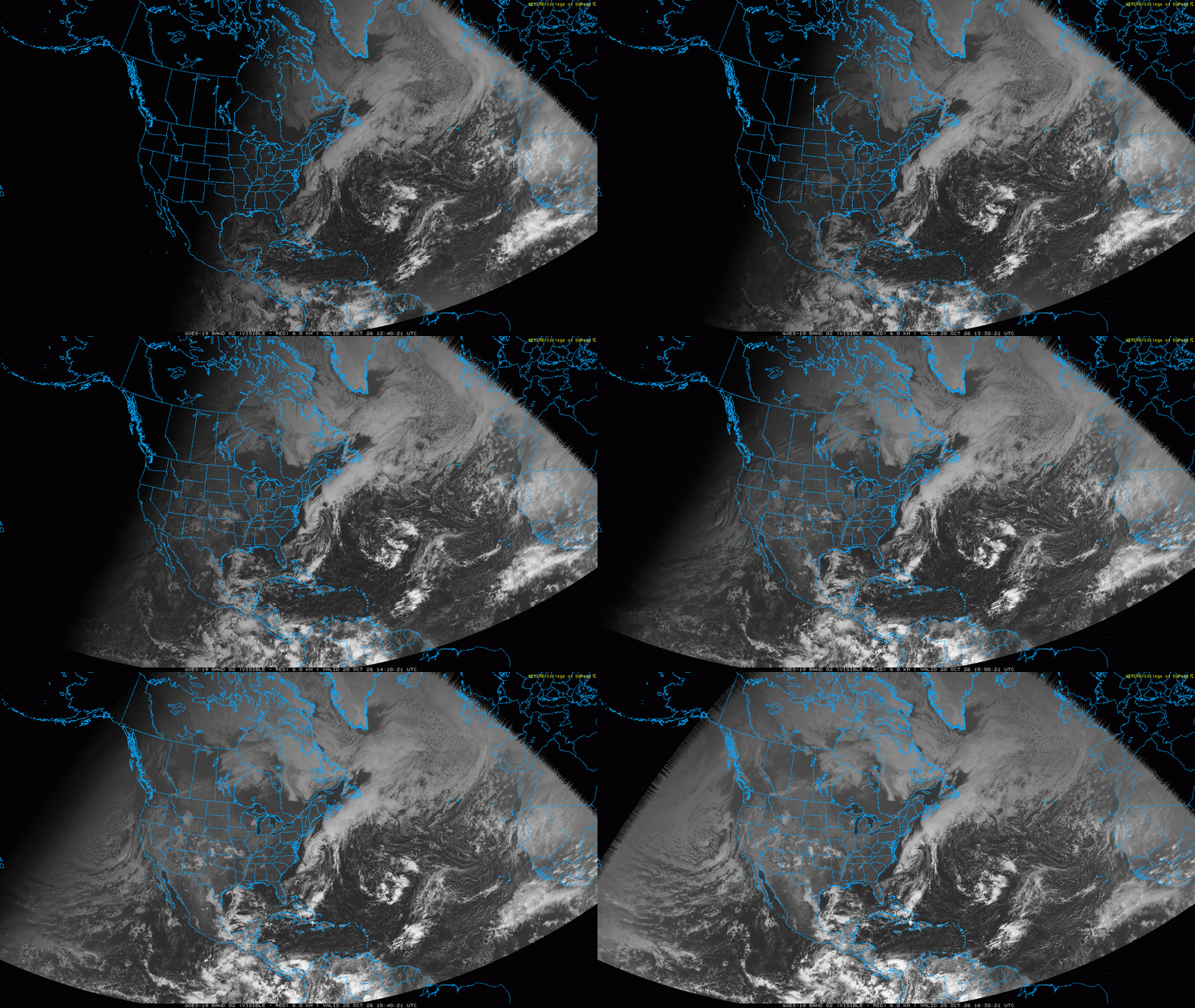
As a reminder, geostationary weather satellites are in a geosynchronous orbit that allow their instruments to continually observe our planet from an essentially fixed location. NOAA’s longtime GOES program has provided continually advancing environmental data that has helped dramatically improve weather forecasts and warnings over the last five decades. The last of the GOES satellites — GOES-19 — was launched in the summer of 2024, and NOAA has been planning the next generation of satellites called GeoXO for a number of years. Last year, the Trump Administration announced a series of budget cuts and changes to the scope of the GeoXO program.
As a major federal program, a bipartisan group of congressional representatives requested the Government Accountability Office (GAO) to conduct a review of the GeoXO program back in 2024. On Friday, GAO announced the results of that study, which were reported on by CNN weather and climate journalist Andrew Freedman in his story yesterday.
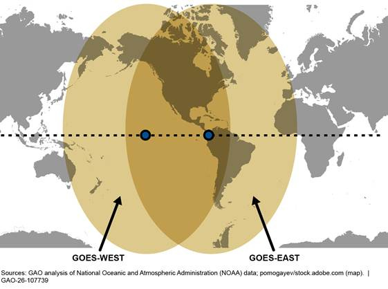
The most important and pressing concern that GAO found is the potential for a gap in geostationary satellite coverage. In order to ensure adequate coverage of the United States and its interests by geostationary satellites, NOAA requires that there must be three geostationary weather satellites in orbit at any one time. One of these (GOES-East) is positioned to ensure coverage of the eastern United States and Atlantic Ocean, another the western United States and Pacific Ocean (GOES-West), with a spare satellite ready to take over for either of the operational satellites should a catastrophic failure occur.
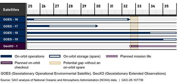
There are currently four GOES satellites in orbit: GOES-18 and GOES-19 are providing operational data, and GOES-16 and GOES-17 are spares that will be reaching their anticipated end of life in the early 2030s. As of now the first GeoXO satellite is not projected to launch until mid-2032, about the same time as GOES-16’s anticipated end of life. Given that a new satellite is not operational for several months after launch, that would mean a potential several month gap without any backup satellite.
Of course, this is all dependent upon GeoXO actually meeting its target to launch in mid-2032, which based on my experience seems highly unlikely. Almost all major federal programs like GeoXO encounter delays, and GAO noted in its report that “ongoing program restructuring exacerbates risk and uncertainty to the program. In April 2026, the program office updated its baseline schedule. Program officials reported that disruptions in funding could affect the schedule and the 2032 launch, which could increase the risk to geostationary data continuity.”
Also of concern is the significant descoping of the GeoXO program. The initial vision of GeoXO had actually planned for four satellites to be in orbit at one time, with an additional operational “central” satellite. Per the GAO report, that concept was scrapped in the summer of 2025 based on directives from the Trump Administration to reduce life cycle costs.
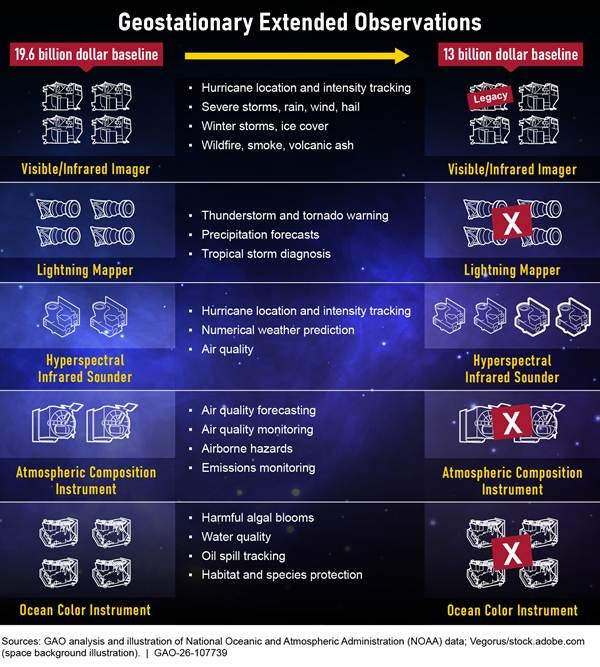
This descoping also resulted in a significant reduction in planned instruments for the new satellites. As I discussed in my August 2025 article, in budget directives the administration ordered NOAA “to develop a program redesigned to fit budget constrats (sic), not maximize new capabilities.” As a result NOAA eliminated all of the planned advanced and new instrumentation for GeoXO, focusing strictly on deploying baseline imagers and sounders on the satellites. In fact, the initial GeoXO satellite will likely utilize an extant imager built for the GOES program.
While all of the instruments that have been cut from GeoXO would have provided various benefits, the loss of greatest concern to me is the lightning mapper instrument. This instrument is a part of the current GOES satellites as the GOES Lightning Mapper (GLM), and has been an incredible boon to the meteorological community.
Other lightning detection networks have existed for decades, but they are ground-based and mostly commercial and proprietary. GLM is unique in being a space-borne instrument that provides public lightning mapping data not only over land but also over oceanic areas, allowing for applications not possible before such as monitoring lightning activity in hurricanes. As Andrew Freedman said in his article:
This sensor (GLM), first deployed on a GOES satellite in 2017, can detect lightning flashes anywhere on the globe and has proved to be useful for predicting tornadoes as well as monitoring the rapid intensification of tropical storms and hurricanes. Other applications include weather forecasting for aviation and wildfire monitoring. The first GeoXO satellite will have none of those instruments on board (including GLM) when it launches in 2032, the GAO report stated.
Obviously, the imager and sounder — which is the instrument that retrieves temperature and moisture data utilized in weather models — are the most crucial instruments for basic weather monitoring and meteorological applications. However, losing the GLM capabilities, not advancing the imager and sounder technology, and dropping the other instruments raises serious concerns that we are taking a step backwards in our satellite capabilities. GAO said as much in the conclusion to its report: “it is unclear whether GeoXO will improve, or even continue, the functionality available in the current generation of satellites.
With society becoming increasingly sensitive to weather, taking a step back in our capabilities of such foundational meteorological technology as geostationary satellites is very concerning to me. Technology is moving forward quickly and perhaps new capabilities such as small-satellites will help fill potential gaps — but as of now, those solutions are in the future. Geostationary satellites have been a huge part of the dramatic improvements in weather forecasting in recent decades, and the data they currently provide will play a key role in what I expect to be an ongoing revolutionary improvement due to new AI and modeling approaches. Hopefully, this GAO report and its recommendations will help Congress and NOAA ensure that we develop GeoXO and other programs to keep our meteorological progress going.
I will have a post or video about the various ongoing weather situations later today.


Leave a Reply