
San Juan River at Farmington, NM cresting feet above 100+ year old record, law enforcement official describes area around Pagosa Springs, CO as “catastrophic”
4 minutes ago
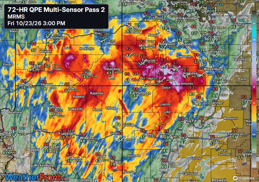
Along with all of the severe weather and tornadoes the last couple of days, the shower and thunderstorm activity moving across the Southwest has resulted in heavy rainfall and flooding. Particularly hard hit has been southwest Colorado, where a large footprint of 4-9” of rainfall has occurred.
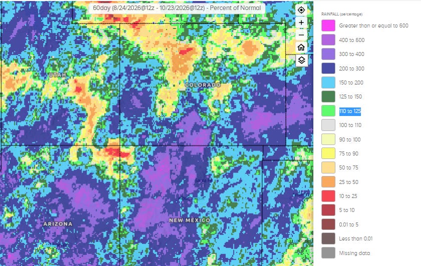
As we have been discussing, this region has been getting repeated bouts of heavy rainfall in the last several weeks as weather systems have been pulling moisture northeast out of the active tropical eastern Pacific. Much of the higher elevations of Arizona, New Mexico and southern Colorado have had as much as five times their normal rainfall in the last 60 days.
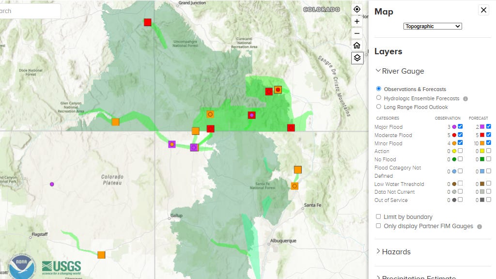
In addition to the flash flooding, this most recent round of heavy rainfall on top of all of the prior rain has led to significant river flooding, particularly along the San Juan River that flows west out of its headwaters in the San Juan Mountains of southern Colorado.
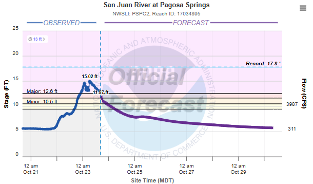
The town of Pagosa Springs, CO on the San Juan was seriously impacted just over a year ago by major flooding. The crest this morning was more than 2 feet higher than what was observed last year — and the second highest to a 17.8’ crest all the way back in 1911. Numerous evacuations and rescues have been required, and Archuleta County Sheriff Mike Le Roux told the Pagosa Springs Sun, “everywhere is a disaster. It is catastrophic.”
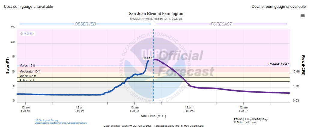
As floodwaters move down the San Juan as well as its tributary the Animas River, record flooding is occurring where the two rivers meet at Farmington, NM. At Noon CT the river had reached 14.07’ — the gauge appears to have failed as there has not been an update since. The Noon level was nearly 2 feet above the prior record of 12.3’ set in 1909. The river stage on the San Juan at Farmington has not even reached the 10’ moderate flood stage since the 1961 construction of the Navajo Dam on the San Juan above Farmington, so this is truly almost unimaginable flooding for this region. SourceNM reports that at least 1,500 homes have been damaged and more than 60 people have had to been rescued in the region.
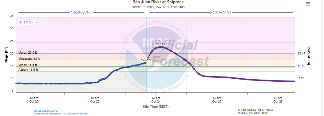
The flood wave will next be reaching Shiprock, NM, where the 23.17’ forecast crest is more than 8 feet above the prior recorded highest level of 14.5’ in 2005.
Another area preparing for potential flooding are coastal areas of the Southeast, where King Tides — an annual peak in astronomical high tides due to lunar and solar alignments — will coincide with meteorological conditions to produce the potential for some severe coastal flooding.
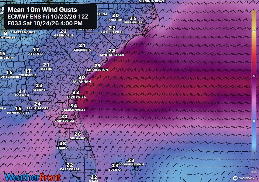
Strong northeast winds in the wake of Subtropical Storm Josephine have already been causing coastal flooding and beach erosion along the East Coast this week, and as strong high pressure builds south this weekend, winds will increase further, starting along the Carolina and northeast Florida coast.
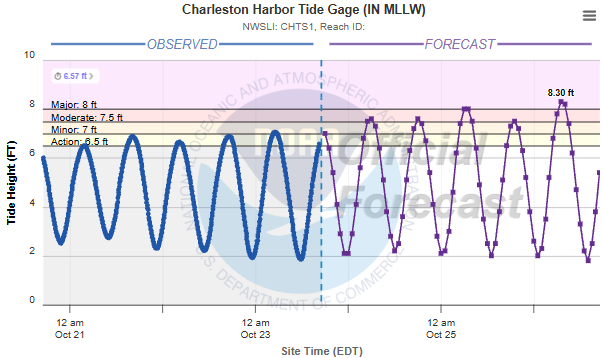
This will cause water levels to continue to rise as the King Tide cycle peaks early next week, resulting in the forecast water level in Charleston Harbor to exceed major flood stage for the high tide cycles Sunday and Monday morning.
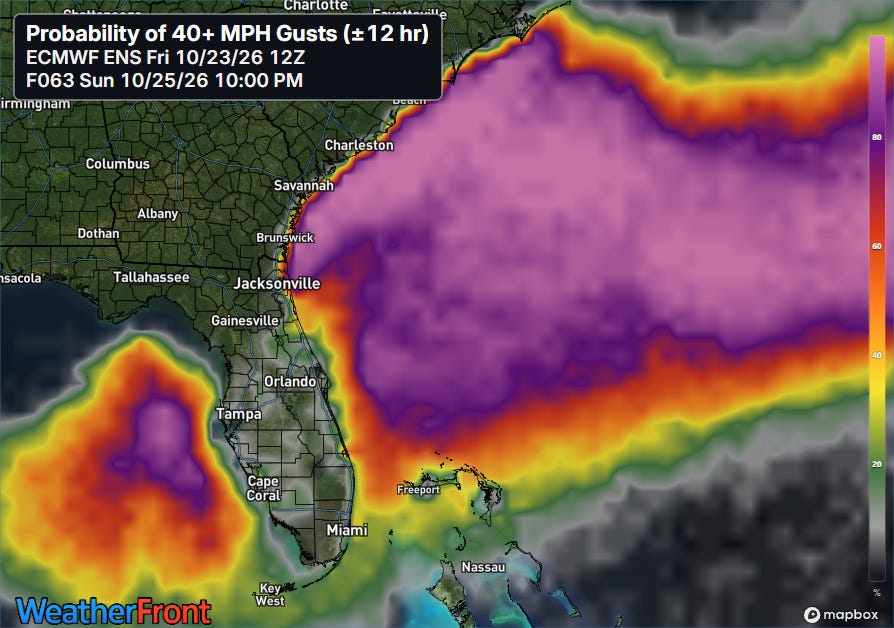
The strong winds will expand south into Sunday, with high probabilities for winds gusting over 40 mph building toward south Florida.
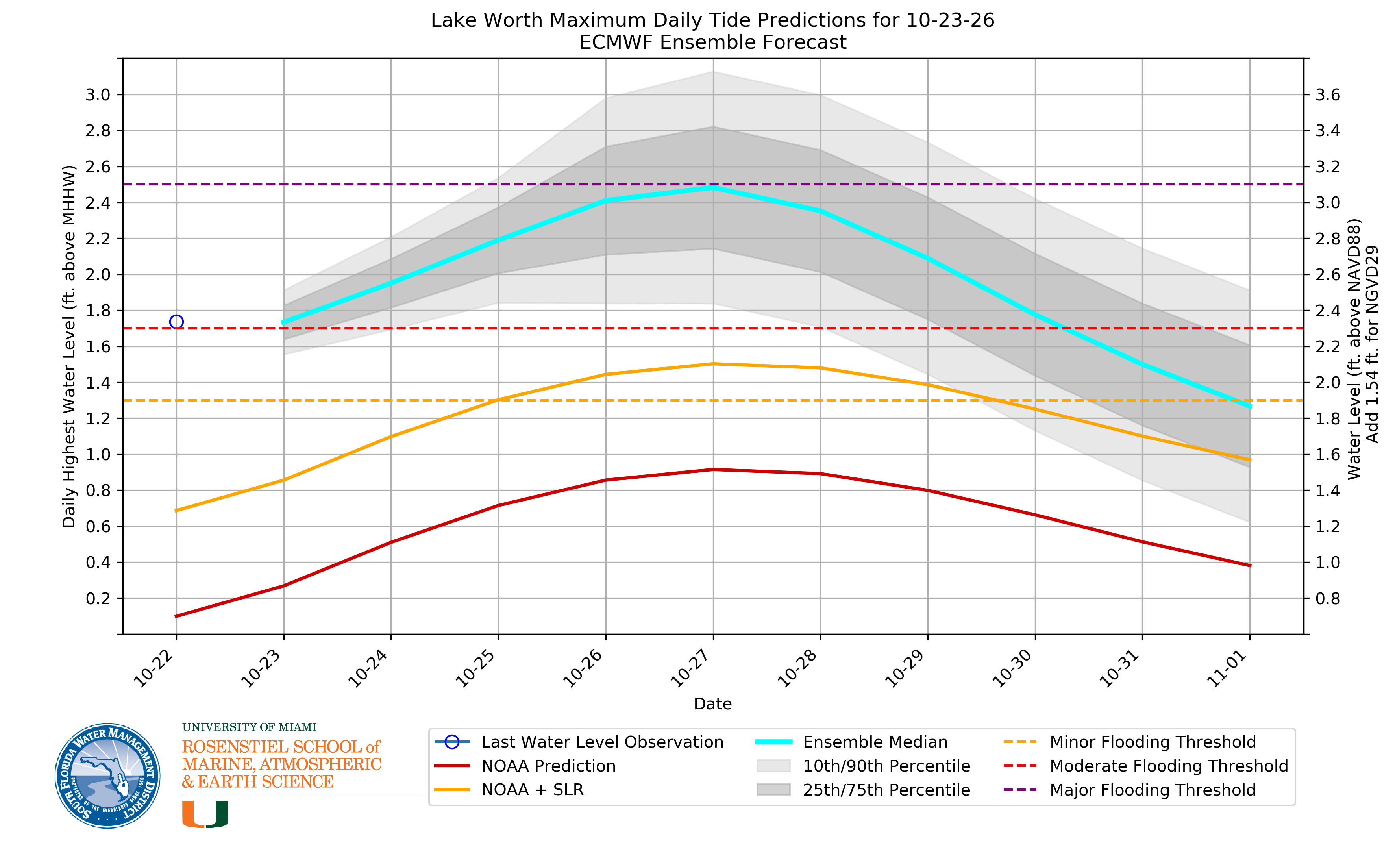
The median water level forecast for Lake Worth, FL based on the European ensemble model takes the level to around major flood stage on Monday and Tuesday as the King Tides peak.
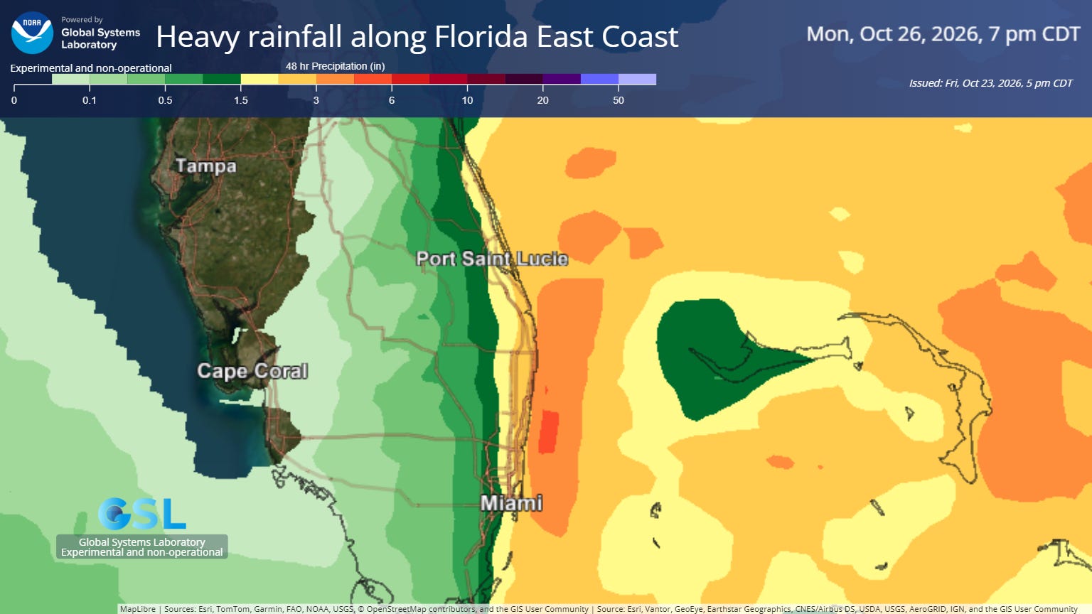
The flooding situation could be exacerbated along the southeast Florida coast as the onshore flow will produce bands of showers and storms with heavy rainfall.


Leave a Reply