
Melbourne sets a new record for wettest November ever – on November 2nd. Also – NWS retires a number of “vintage” weather models.
4 minutes ago

Today, the National Weather Service officially discontinued four numerical weather prediction (NWP) systems that have been an important part of operational meteorology for many years: NAM (North American Mesoscale Model), SREF (Short Range Ensemble Forecast system), HREF (High Resolution Ensemble Forecast System), and the High Resolution Window and HREF individual members (ARW, NSSL and FV3 high-res WRF models).
The NAM model has been around in some form for most of my career. It was initially introduced as the Eta model in 1993, replacing the LFM (Limited Fine Mesh) model which had been one of the earliest operational NWP systems. It was a significant advancement in operational NWP, particularly when the Eta evolved into the higher resolution Meso-Eta in 1996 and began to give meteorologists the ability to anticipate smaller scale weather events. The Meso-Eta eventually became the NAM in 2005, and has been running in the same basic configuration for two decades.
The SREF was one of the initial operational forays into ensemble forecasting with post-processing, i.e., applying techniques to give probabilities of specific impacts and weather phenomena. It was introduced in 2001, and had periodic upgrades over its 25 years of operations. The HREF evolved out of experiments with very high resolution convection allowing models (CAMS) in NOAA’s Hazardous Weather Testbed and provided meteorologists with post-processed guidance for many severe weather, flash flood and winter weather phenomena.
One might think that given the continuing advance of science and computing that models of this “vintage” must be completely obsolete. That is not really true, though. Over the years as meteorologists gain experience with a particular model, we learn their biases and idiosyncrasies and can continue to find them valuable in the forecast process. For this reason, model systems tend to just be allowed to continue to run, and it causes angst when they are finally discontinued.
That has certainly been the case with the sunsetting of these models, as there has been a lot of discussion and actual opposition within the weather community to the NWS making this change. Running computer models, even ones that are older and no longer being developed, takes significant computing resources as well as human resources to keep model code up to date for always changing observation systems, communications networks, etc. Eventually, you have to pull the plug to make resources for newer state of the art systems — which is what the NWS did here with the new Rapid Refresh Forecast System (RRFS, replacing the NAM and eventually HRRR) and RRFS Ensemble Forecast System (REFS, replacing the SREF and HREF) now operational.
To me, there is some valid concern about the discontinuing of the HREF and its member models. Most ensemble forecast systems such as the European global ensemble (EPS) and US Global Ensemble Forecast system (GEFS) are a single modeling system in which the initializing data is “perturbed” to generate the various ensemble members. The HREF was different in that it was comprised of actual differing models with different model cores and physics packages.
My sense is there is still a lot of real scientific debate in our community as to whether very high resolution forecasts for thunderstorm hazard forecasting can be done most effectively with a traditional single model ensemble system — which is what the new REFS is — versus a system constructed like the HREF. To be fair, I have been using the REFS much more heavily myself over the last few months and so far have found it to be an excellent forecast tool — and my understanding is that it was evaluated favorably in NOAA Hazardous Weather Testbed experiments.
A separate major concern about the termination of the HREF is its impact on AI approaches to severe weather and flash flood forecasts. I have written extensively about the Nadocast system which has been producing probabilistic severe weather guidance that the community has found very useful — including the NWS Storm Prediction Center, which has helped collaborate on this and other AI severe weather forecasting approaches.
Nadocast was trained on HREF data and utilized HREF data to generate its forecasts. As a result, with the demise of the HREF, Nadocast is no longer generating products. My understanding is that there is testing going on of a version that would run off of the REFS model, but to my knowledge there is no firm plan (if someone knows otherwise, please comment below, comments open to all).
Hopefully given the traction that Nadocast has gained within the NWS and broader community, there is some sort of collaborative effort happening to try to revive Nadocast using REFS data. Regardless, the AI world is definitely a new aspect that NWS is going to have to account for going forward. AI approaches need a sufficient amount of historical model runs or reanalyses to train on, and once an AI system is developed and becomes integrated into operations, the need for the model data it relies on will have to become an important operational consideration for when a modeling system can be discontinued.
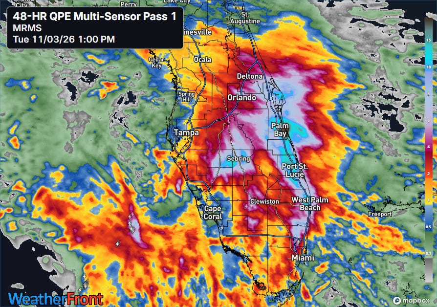
Turning now to weather, I mentioned Florida flooding in yesterday’s post, but clearly I was distracted by the Four Corners event and was not sufficiently highlighting the significance of what was going on in the Sunshine State. Incredible rainfall has been occurring across much of the Peninsula the last few days due to a combination of extreme levels of moisture from the Atlantic and Caribbean, as well as a slow moving upper level weather disturbance in the region.
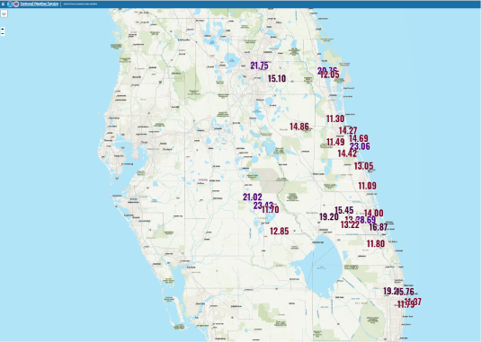
Numerous locations along the east coast of the peninsula as well as central areas — including around Orlando — have reported in excess of 10” of rain in the last 3 days, with many locations totalling in excess of 20”. The highest amount I have seen is 28.69” at the emergency operations center in St. Lucie County.
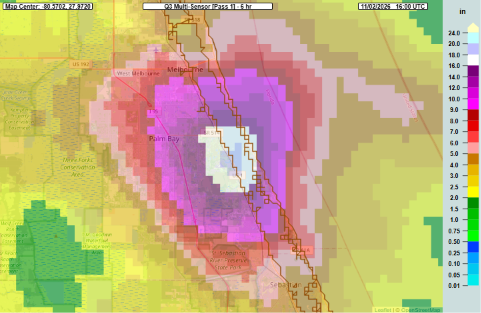
Also hit hard was Brevard County along the east central Florida coast, where the NSSL Multi-radar Multi-sensor (MRMS) system indicated that an incredible maximum of nearly 20” of rain in just 6 hours occurred Monday morning. Two people were killed by flood waters in Palm Bay, and numerous homes were damaged by flood waters with more than 160 people rescued by sheriff’s deputies and Florida Fish and Wildlife officers. A staffer with the county emergency management told Florida Today “we were still finding people stranded in cars as of 2 am Tuesday.”
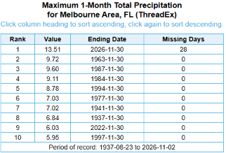
To give some context on just how insane the rainfall was, the official NWS observing site in Melbourne recorded 11.51” of rain for the calendar day Monday. This was a new record calendar day total rainfall ever, eclipsing the 10.23” that fell during Hurricane Irma on 10 September 2017. Perhaps more remarkably, just 2 days into the month, Melbourne has already shattered the record for its wettest November on record with a total of 13.51”, besting the previous mark of 9.72” set in November 1963.
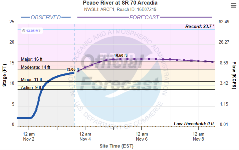
The widespread heavy rainfall is causing some significant river flooding in the region, including the Peace River forecast to go into major flood which would impact homes in region around Arcadia.
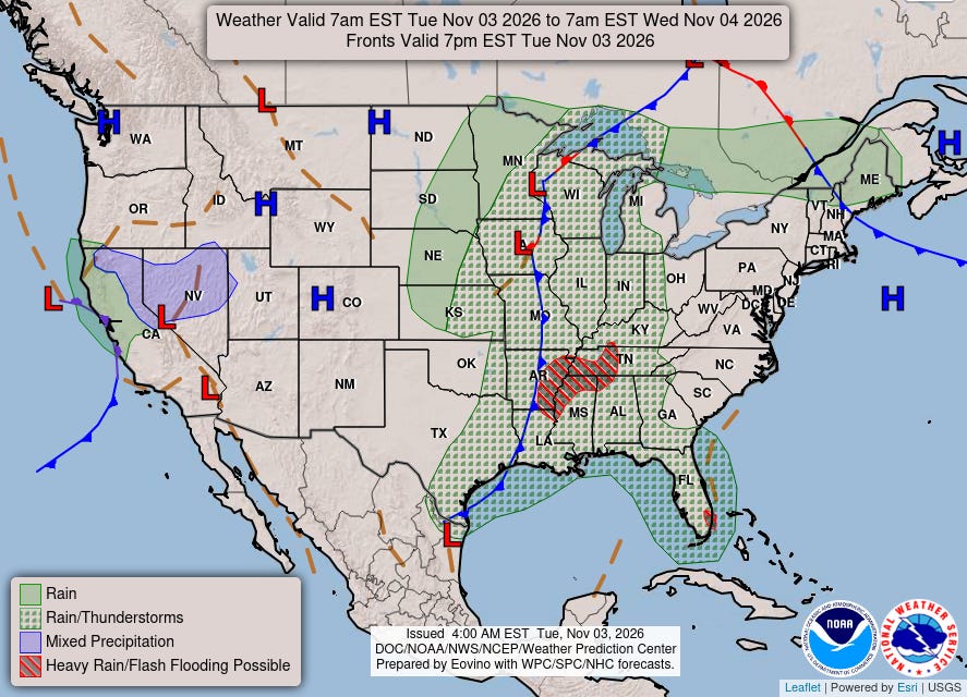
The weather overall is trending quieter today, although there are still active thunderstorms across the central and southeast parts of the country with a few severe storms and some flash flood risk. I will have detailed wrap-up of the Four Corners flooding situation in tomorrow’s newsletter.


Leave a Reply