
Also, high level thoughts on the impacts of the election to federal weather science.
3 minutes ago
Happy hump day! Obviously, the big national news this morning is the political earthquake that has struck Washington, DC, with both chambers of Congress changing from Republican to Democratic control by sizable margins. This will obviously have major implications on federal science budgets and policy for the next two years — but I feel like it is really too soon to make any major statements other than the expectation that Democrats will be championing quite different priorities, particularly when it comes to climate issues and the priorities and plans of the National Science Foundation. Congressional priorities for a lot of NOAA and NASA issues were already relatively bi-partisan, particularly in the Senate, but obviously the relevant committees will all have new leadership. More to come on all of that of course.
I want to bring attention to a NWS specific issue that I discovered yesterday. For those of you who have been with Balanced Weather from the beginning, you know that I have extensively covered the ongoing issues with the NWS upper air balloon network. These issues have included a number of sites being inoperable for extended period of times due to facilities and maintenance issues, as well as missing and delayed flights due to staffing constraints.
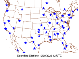
These issues have been resulting in large parts of the country, particularly in the central and western United States, missing the morning (1200 UTC) balloon flight required by World Meteorological Organization (WMO) standards. The map above shows a typical plot (from Storm Prediction Center website) from just last Thursday of available morning upper air data, with large swaths from the Plains west missing data. While typically a number of the upper air sites would do a balloon release later in the day, a number of meteorologists raised concern over the impacts of this missing data on the ability of forecasters to analyze upper air features and conditions as well as potential impacts on models.
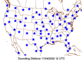
Given that the morning upper air map has looked like the one from last Thursday for months and months, I was quite surprised to call up the map yesterday and find it looking “normal,” with 1200 UTC sounding from pretty much the entire country. I went back and looked at prior days and found that the same full maps back to Sunday, November 1 — the prior day’s map from October 31 looked like the one from the 29th up above.
I reached out to several colleagues still in NWS and discovered that a notice was sent out to local NWS offices several weeks ago directing that all upper air sites would again be mandated to follow the WMO standards for the timing of upper air balloon releases starting November 1. Clearly, offices are following that new mandate — and it appears that at least for now, this situation has been resolved.
Needless to say, I think this is great news. The NWS has consistently tried to say that there has been no degradation of services due to the upper air issues — and the evidence on impacts to the models is mixed and probably varies by the modeling system. However, I do think it made it harder for meteorologists to perform upper air analyses and make morning forecasts, and had other implications for historical data as I outlined in a post back in July. What I am absolutely convinced of after talking to numerous colleagues in the last year is that the upper air data changes and issues impacted many meteorologists’ confidence in data analyses and model output. Resolving this issue should obviously fix that confidence crisis, and enable exciting NWS efforts to tap new data sources such as WindBorne Systems’ navigable balloon systems to be seen as supplemental projects to make our forecasts even better.
I would be remiss if I did not point out that Alaska has been suffering from serious issues with its upper air network for an even longer period of time, and to the best of my knowledge those issues continue. As recently as a couple of weeks ago, my colleague Rick Thoman posted about the extensive missing upper air data as a major storm system was approaching the state. Missing data in Alaska not only has serious implications for forecasts there, but also downstream over the rest of North America particularly during the winter. Obviously, I will be keeping an eye on all of this and will be seeing if there are any caveats with the restoration of normal morning balloon releases — I will pass any new developments along.
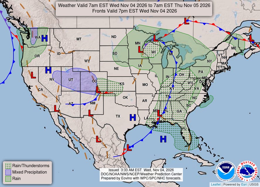
The weather is finally relatively quiet across the lower 48 today. A storm system is bringing showers and thunderstorms to the East, with marginal risks of severe storms and flash flooding over parts of the Southeast.
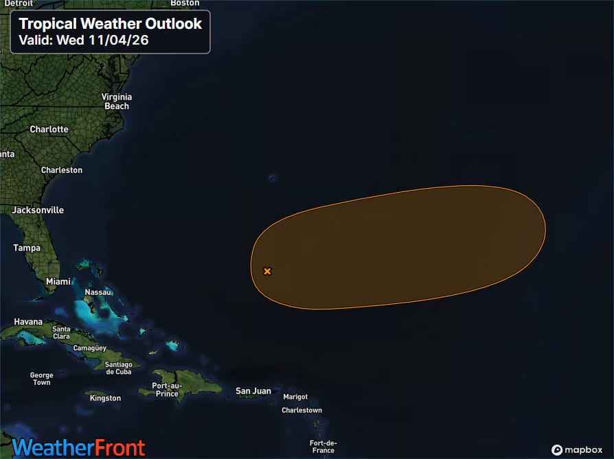
There is a little bit of activity to discuss in the tropics. NHC is monitoring a developing non-tropical low pressure system east of the Bahamas which has potential to gain tropical characteristics over the next few days. NHC puts the probability of development into a tropical cyclone at 50% — but even if it happens it will mainly be of interest to maritime concerns and for the Atlantic tropical seasonal statistics.
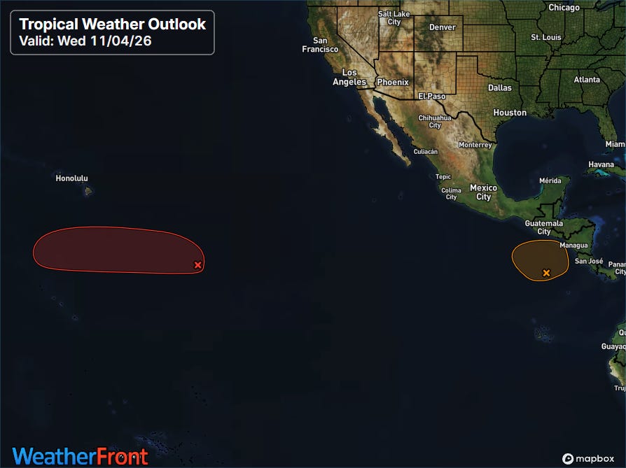
As usual this year, things are busier in the Pacific, with NHC monitoring two areas closely. NHC has a high probability of development on a system to the east-south of Hawai’i — but recent Google DeepMind forecasts suggest this system should keep on a westward track and will remain relatively weak at least until it passes to the west of the longitude of Hawai’i. The system closer to Central America looks as if it will slowly develop and drift east for the next few days — and will be something to at least keep an eye on for that region.
(Programming note: I know I said in yesterday’s newsletter that I was going to do a recap on the Four Corners flooding today, but I thought the NWS upper air breaking news was a high priority. I will get that post out in the next few days.)


Leave a Reply