
Looking at the meteorology, and discussing some of the forecast challenges.
2 minutes ago
Before I get into the meat of today’s newsletter, I want to quickly return to the major flash flood event in the southern Appalachians I discussed in yesterday’s post. My fellow retired NWS meteorologist John Lewis posted on his Substack (which you should follow/subscribe to, especially if you are in the Mid-South region John focuses on) last evening about issues he noted with NWS warnings for the event. The concerns John raised spurred me to spend some time diving into the warnings for the event. While at a high level there were flash flood warnings in effect, this event definitely highlighted concerns again about the complexity of the NWS hydrology and flood warning programs as well as the difficulty of collaborating services across the boundaries of NWS office areas of warning responsibility. I am planning to write a full article about all of this in the coming days once I can do some research on some issues I found — but in the meantime, please check out John’s post.
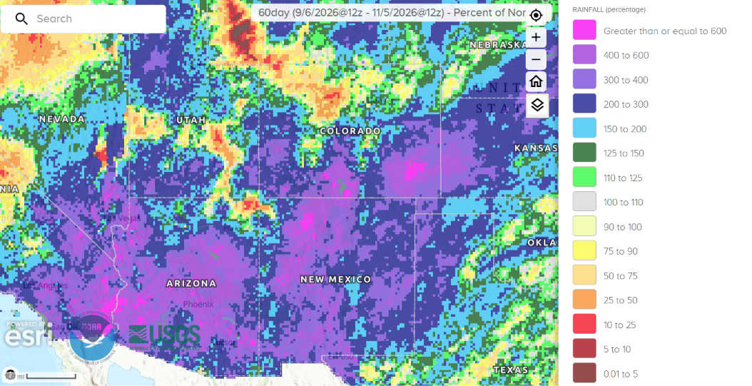
Today I want to share on another topic I have been promising to go back to, the historic Four Corners flooding. This map shows the percent of normal rainfall for the last 60 days — clearly much of the region is way above normal, and there are pockets from southeast California up into southern Colorado where the values are literally “at the top of the chart” with values of 4 to 6 times normal.
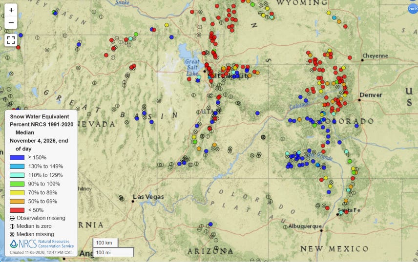
The series of storms — and particularly the last two historic storms in late October and early November — have sent snow water equivalent (the amount of snow on the ground converted to liquid) to extremely high levels in parts of the Four Corners region, with a number of sites at 3 to 5 times their normal values for early November.
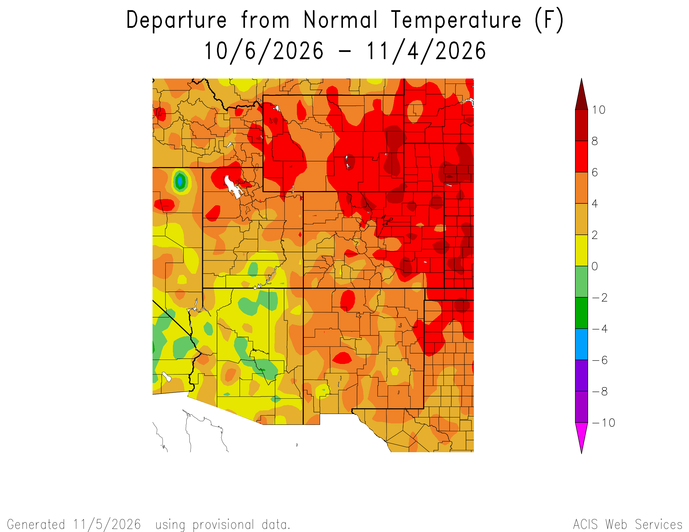
However, this is really only at the highest elevations (about about 10,000 ft) because the weather pattern has along with being unusually wet has also been unusually warm, resulting in storm systems with higher than normal snow levels. This meant that heavy rainfall fell at elevations which typically would get snow at this time of year, which drastically increased runoff and flooding.
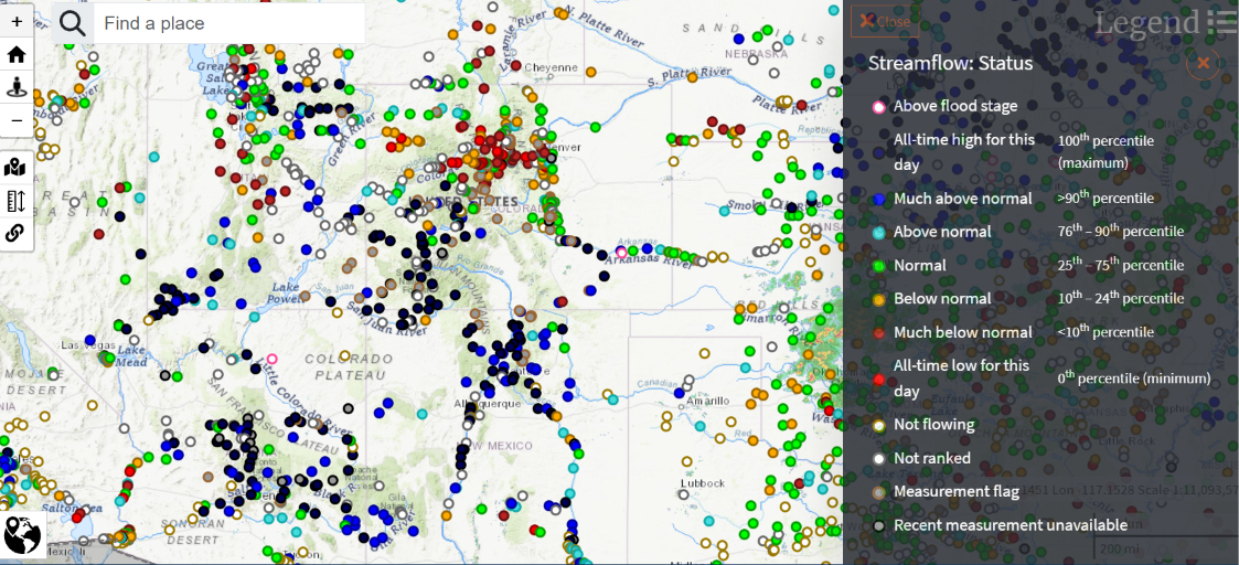
A number of rivers and streams set records in one (or in a few cases, both) of the major storm systems in the last couple of weeks. Even as water levels recede from their flood peaks, numerous USGS stream gauge locations across the Four Corners region are at record high levels for the date. In an interesting demonstration though of how much precipitation can vary across a small area (especially when terrain is involved), many locations across north central Colorado are seeing much below normal streamflows while just a few dozen miles away streams are at daily record high levels.
Hydrologic forecasting can be very complicated and challenging as there are many factors that have to considered and modeled. Rainfall — which before an event is based on forecast amounts, and afterward based on multi-sensor analyses including radar and gauge measurements — has to be converted into runoff in order to model how river levels will respond. Antecedent soil conditions, terrain, and a number of other factors figure into those estimates of runoff. Of course there are additional complexities once the runoff makes it to rivers and one has to deal with things like dams, potential levee overtopping, the complexity of different timed flood waves meeting at river confluence points, etc.
Luckily, the NWS does have dedicated River Forecast Centers whose main mission is hydrologic forecasting — and these centers have certainly helped improve river forecasting in their decades of existence. Even so, there still remain lots of challenges, and this was demonstrated in this most recent Four Corners event.
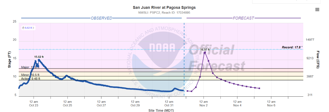
This was the forecast issued late Saturday night for the San Juan River at Pagosa Springs, CO — a very critical location given multiple major floods over the last year or so. The forecast took it to just under 17’ — shy of a record but above the levels of the most recent serious floods. At the time this forecast was issued, some rain had already fallen but most was still ahead, so this forecast was likely based primarily on forecast rainfall.
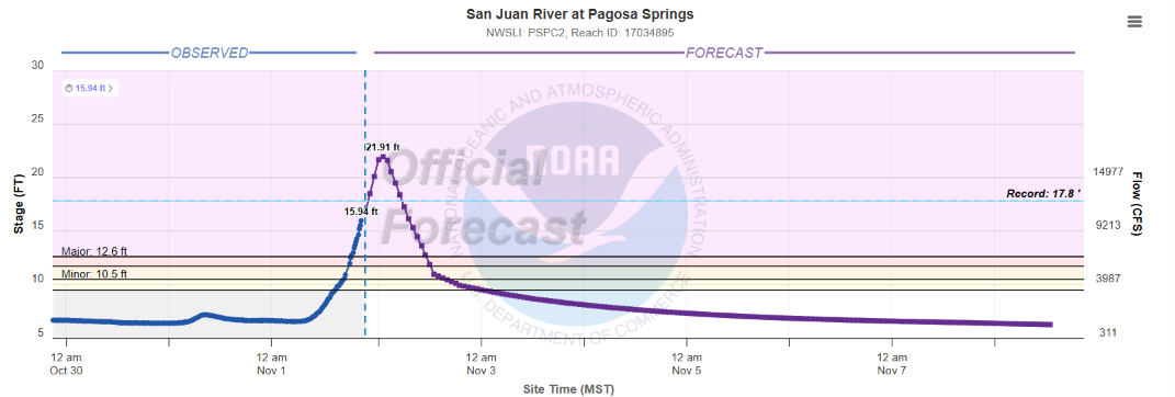
By Sunday evening, after most of the rain had fallen and the river had started to rise — theoretically meaning more concrete data was available — this forecast was substantially revised upwards to a crest of 21.91’. This was a crest well above the record of 17.8’.
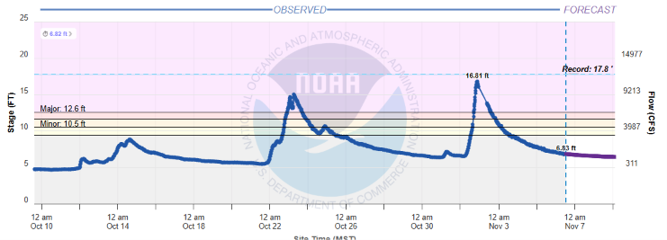
As I discussed in posts earlier in the week, while an instrument failure means we do not know exactly what the highest level the river might have attained, it clearly did not reach the forecast crest and likely fell just short of the record.
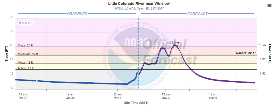
Another location that has been in the news this week is Winslow, AZ, where by Sunday evening the Little Colorado River was forecast to was forecast to not only shatter its prior record, but also exceed a critical 25’ level where levee overtopping could bring serious impacts to populated areas by late Monday evening or early Tuesday.
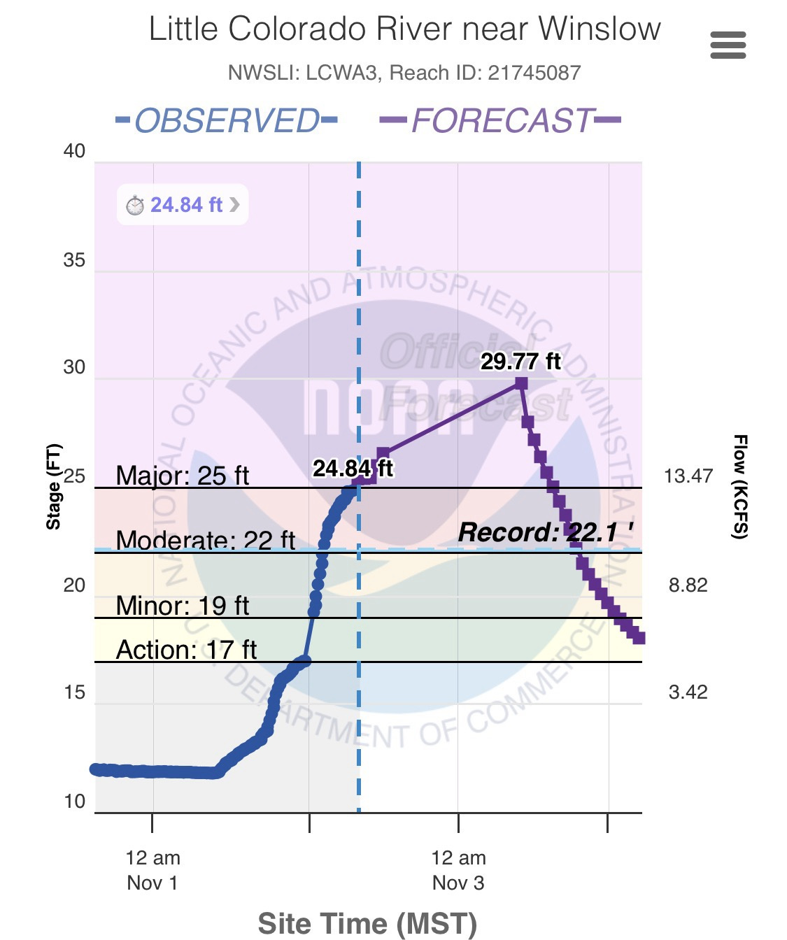
The crest height is obviously not the only important part of a forecast, so is the timing of when it will happen. In this case, the river rose much more rapidly than expected, and by Monday morning was already approaching the critical 25’ level. The NWS forecast crest was substantially raised to 29.77’.
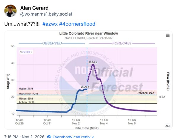
The river behaved during the day Monday pretty much as the earlier forecast has shown, slowly rising above the 25 foot level. Yet, for some reason Monday evening the NWS radically increased the forecast to an incredible level, some 15 feet above the prior record. My post on BlueSky that evening (above) showed my shock and (to be honest) deep skepticism in such a forecast.
Obviously I am not familiar with the details of what the NWS forecasters (in this case at the Colorado Basin RFC in Salt Lake City) were seeing as far as data. However, there are physical limitations on how high a river can go — and the fact that a levee was already being overtopped suggested to me that a lot of any new water coming downstream would tend to spread out in the floodplain on the other side of the levee rather than manifest as higher levels at the river gauge.
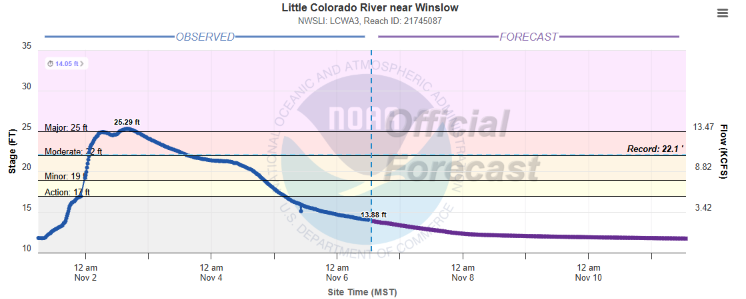
Needless to say, this forecast scenario did not materialize. The river was pretty much at its highest point when that radical forecast was issued, and began to actually slowly fall by early Tuesday. Based on media reports, while a number of homes were certainly flooded, the levee held back most of the worst flooding.
Obviously, it is a good thing that neither of these overzealous forecasts materialized — but there are real-world impacts just from the forecasts. The Little Colorado River nearly reached the level of Interstate 40 even at the level the river actually reached — I can only assume that the forecast issued Monday evening of a further 15 foot rise caused major panic for transportation officials and potentially forced preparatory actions.
These examples are the two most glaring I saw of forecast issues during this event, but there were many others. Some were like these where the forecasts were too high, but a number of others where forecasts were too low which obviously has its own sort of societal impacts. While there is no doubt that hydrologic forecasting can be challenging, I have to admit that I was taken a bit aback by some of these struggles and have to wonder if inexperienced NWS forecasters could have played a role. The NWS is also going through a transition in its hydrologic program to a larger role for the National Water Center in Tuscaloosa and more reliance upon the National Water Model. I hope the NWS is conducting a serious internal post-event evaluation of this historic flood to ensure that whatever the reasons for some of these forecast issues are discovered and corrective actions are taken.
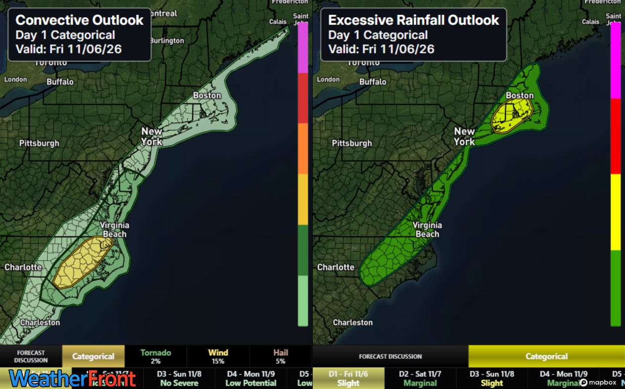
As far as today’s weather is concerned, the slow moving cold front moving along the East Coast will bring some active thunderstorms today, with some risks of severe weather and flash flooding.
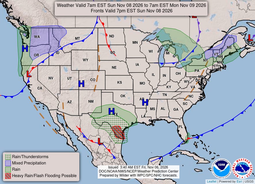
Overall, a relatively quiet weekend is anticipated as far as hazardous weather is concerned, although some risk for heavy rain and flash flooding will begin to build over south Texas on Sunday.


Leave a Reply