
Impacts from El Nino expected to continue to build as we head into winter
24 hours ago
Happy Monday!! Before I get into what’s going in the weather this week, I wanted to circle back to yesterday’s newsletter about the record flooding in the southern Appalachians. My post led to quite a bit of conversation in the comment section, and in the discussion this video from MyRadar senior meteorologist Matthew Cappucci was shared. Matthew took a detailed look at some of the significant issues that arose with the severe weather outbreak in the Southwest a couple of weeks ago, including the late warning for the significant tornado that impacted Heber-Overgaard, AZ, and it is definitely worth a watch.
I particularly want to highlight his discussion starting at about 5 minutes into the video about pushback that he has received from the weather community for pointing out issues with NWS warnings and services. Matthew describes his support for and collaborative relationship with the NWS and its incredibly dedicated staff — but also explains why he feels like that bringing awareness to NWS shortfalls and concerns is still needed: “you can be pro-Weather Service and pro-accountability, because that is pro-science.” I could not agree more.
I dedicated my entire professional life to NOAA and the National Weather Service, and trying to make public warnings and services for hazardous weather the best they can be. When I see organizational issues that have plagued the NWS for decades leading to situations where we have two cities lying along a state border and one has a warning for life threatening flash flooding and the other has no warning at all — followed later in the event by a situation where the downstream city has a flash flood emergency and the upstream city does not — I think that needs to have awareness brought to it.
As Matthew alludes to in his video, I am not trying to pile on the individual forecasters involved — I have been in their shoes, and I have no way of knowing the specific challenges they were facing that night. What I am trying to raise awareness of are the serious issues related to communications, organizational structure, training, etc. which has resulted in these being chronic problems with NWS services for years. The reality is that our system of government means that these sort of issues generally only get resolved when there is public awareness and concern. Hopefully, more weather community members bringing these issues to the fore will bring true change that will make the critical services the NWS provides better.
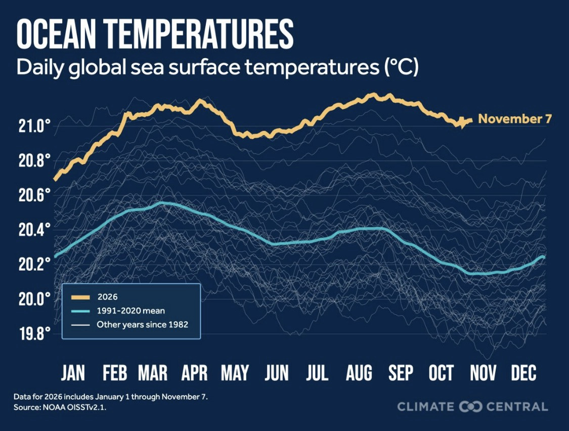
Climate Central meteorologist Zachary Labe shared this graphic today showing that global sea surface temperatures (SST) have now set a daily record for 150 consecutive days. The current global mean SST is about .25 degrees C warmer than the prior record — a rather astounding difference.
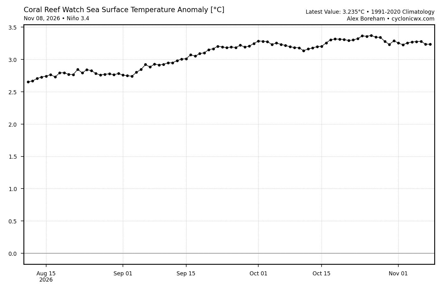
A big contributor to these record warm SSTs is the ongoing intense El Nino. The SST anomaly in the critical Nino3.4 region of the east central equatorial Pacific has been generally holding around +3.25C, near a record high level.
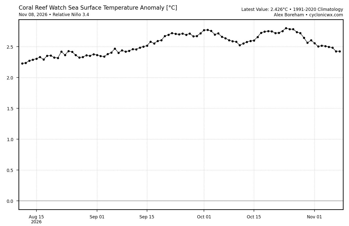
However, the new Relative Nino index, which compares the Nino3.4 anomaly to the rest of the global tropics, has actually decreased a bit in the last couple of weeks. Given that there has been relatively little change in the actual Nino3.4 anomaly, this suggests the the remainder of the global tropics are seeing warming SSTs.
And it’s not just in the tropics themselves. San Francisco Chronicle meteorologist Anthony Edwards shared these charts yesterday showing that SST anomalies along the entire California coast are extreme, approaching 7C/12F in the warmest areas.
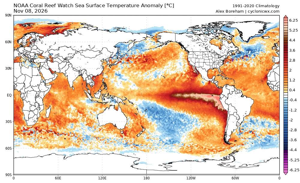
While there are exceptions — notably the south central Pacific and north central Atlantic — much of the globe is dominated by well above normal SSTs.
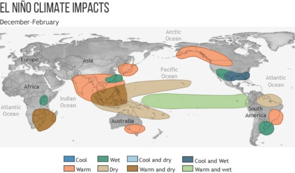
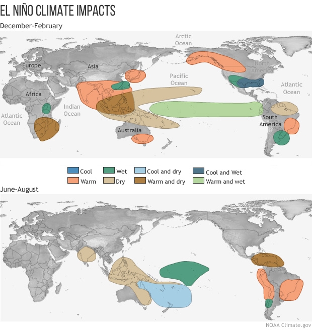
As we head into the peak of winter in the Northern Hemisphere and summer in the Southern Hemisphere, these impacts are favored in the global climate due to the strong El Nino. The SST anomalies outside of the tropics will potentially enhance or modify these impacts. For example, the anomalously warm ocean temperatures off the Pacific coast already are worsening coastal flooding as well as likely contributing higher levels of atmospheric moisture in support of heavy rainfall that the Southwest has been experiencing in recent weeks. Obviously, we will be monitoring the trends of all of this in the coming weeks and months.
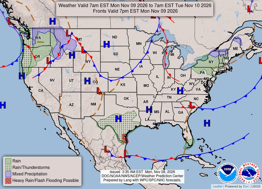
The weather picture today is relatively quiet — at least in comparison to what we have seen much of the last few months. A storm system has been bringing strong winds and some heavy precipitation to the Pacific Northwest, and a subtropical disturbance is bringing thunderstorms to Texas including some risk for flash flooding, particularly in far southern Texas.
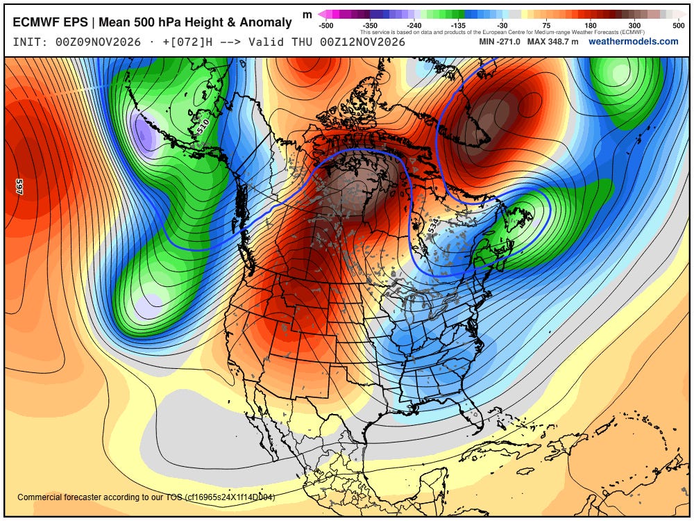
As we head into the week, we will see a bit of a departure in the jet stream pattern from what we have seen of late. A strong ridge of high pressure aloft will build across the western United States, while downstream a deep trough of low pressure will evolve over the East.
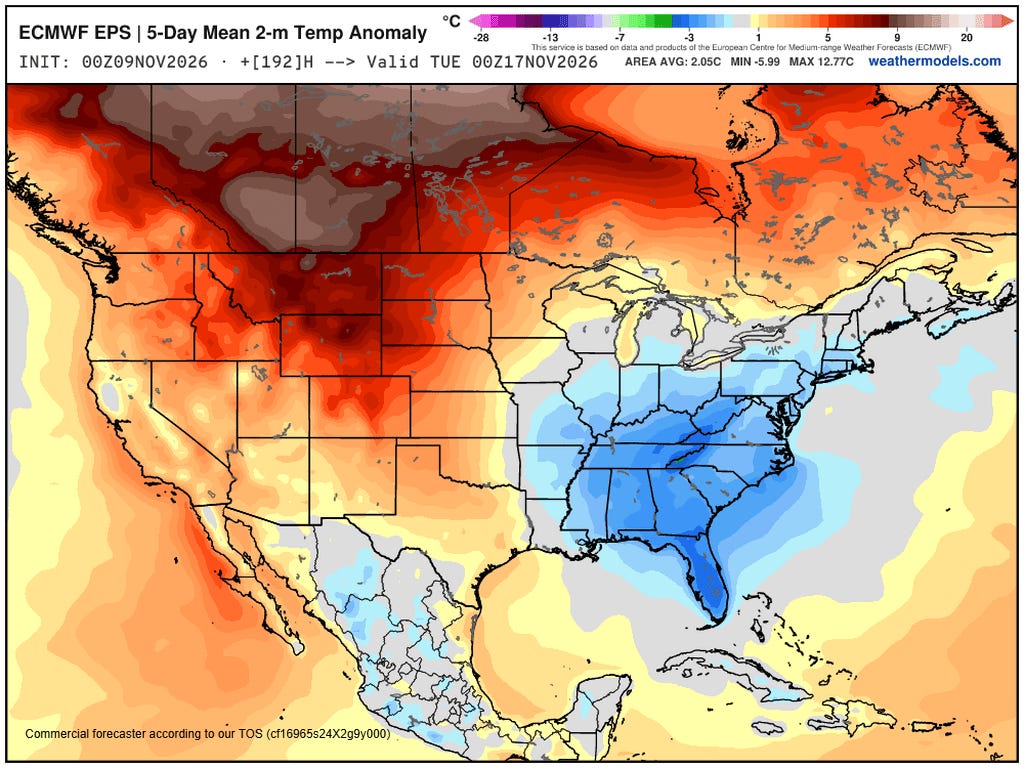
This will yield colder than normal conditions east of the Mississippi — and particularly in the Southeast and Florida — later this week and into the weekend. Meanwhile, the West will see well above normal temperatures with some record warm temperatures possible.
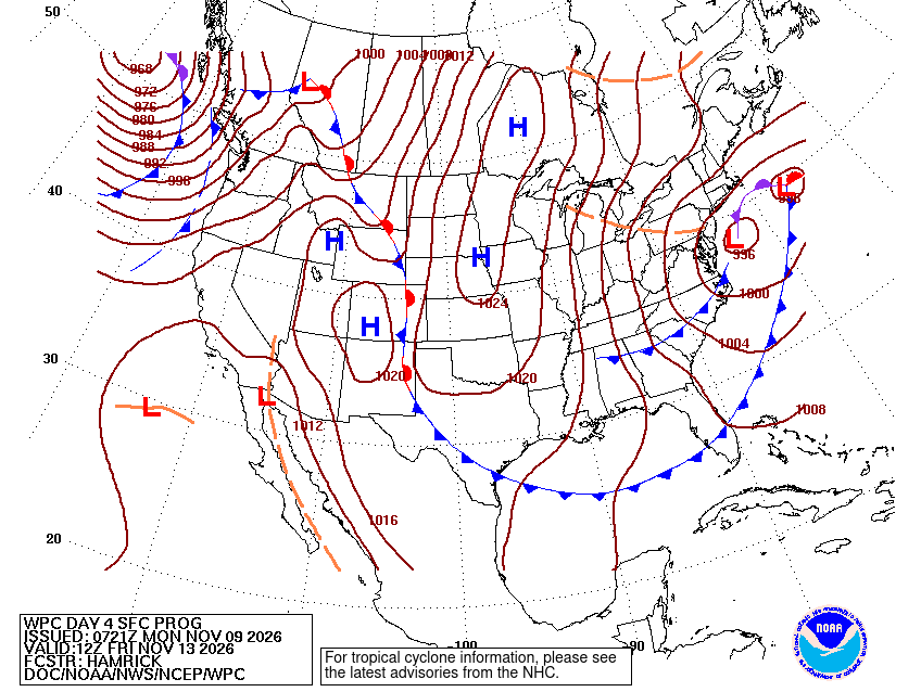
A strong storm system is expected to develop across the Mid-Atlantic during latter part of the week and move off the Northeast coast this weekend. This will bring some rain and high elevation snow to the Northeast quarter of the country.
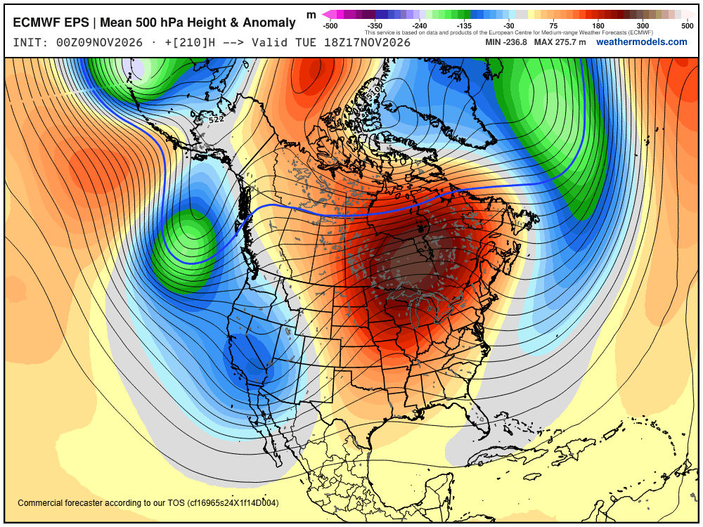
This change in the weather pattern is expected to be short-lived, though, as by early next week a strong trough of low pressure will evolve along the West Coast, with a series of storm systems expected to impact that region. The subtropical jet stream is also expected to become quite active — a very typical aspect of El Nino winters — which could bring increased storminess to the Gulf Coast and Florida.


Leave a Reply