Supported by flat out insane warmth and moisture in the southern and eastern US
I have been talking so much about severe weather and flash flooding this week, I feel like I have been a little remiss in talking about another big story this week from a climate perspective: the record warmth in the southern and eastern US. I saw a BlueSky post a few minutes ago that made me think I should at least spend a few lines at the start of this morning to talk about it.
The warmest temperature at 5 am in a month at a long record station like Washington DC would be impressive enough, but the fact that it is occurring on April 4th – right at the start of a month transitioning toward summer warmth – is truly insane. And it’s not just in DC.
Record warm monthly minimums at the beginning of April is just truly bonkers (sorry, I don’t know what else to say). While the record warm minimums are the huge story, obviously there have been record warm highs too, as 80s, 90s and even some 100s have been common from the Southeast into Texas. Laredo, TX hit 106F yesterday as the warm spot in the US. (BTW, Extreme Temps around the World is a great BlueSky follow!)
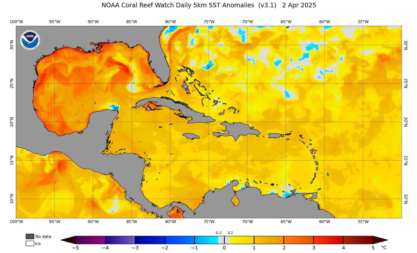
Not surprisingly, this story of warmth is directly related to the weather stories that have dominated the headlines this week: severe weather and flooding. You cannot get record warm minimums in the warmer months in the southern and eastern US without not only a warm weather pattern, but also above normal moisture in lower levels of the atmosphere. A major contributor to that right now is much warmer than normal sea surface temperatures (SST) over the Gulf and Caribbean as shown above. SSTs are running 2-4C above normal in the Gulf, which directly contributes to much higher than normal surface dewpoints over the eastern half of the country when we have southerly flow from the Gulf, which enables the bonkers record high minimum temperatures.
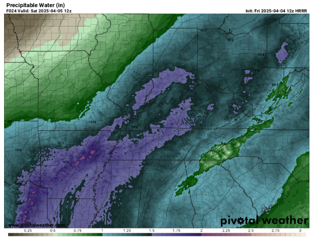
This also directly contributes to the magnitude of the severe weather and flooding. Precipitable water (PW) is a key parameter that meteorologists use to gauge how much moisture is in the atmosphere to support heavy rainfall. The morning upper air observation for PW at Little Rock was 1.52”, which is right at the daily running median maximum for that value as calculated in SPC’s sounding climatology. The forecast from the morning high resolution HRRR model shown above shows that the PW values will increase even more in the region over the next 12-24 hours, with widespread 1.5+” PW values across the lower Mississippi and Ohio Valleys Saturday morning and some values approaching 2”. This is record moisture for this time of year available to fuel record rainfall, and it is directly supported by the moisture being supplied by the unusually warm Gulf. This higher low level moisture also helps provide greater instability that supports the severe thunderstorms this week.
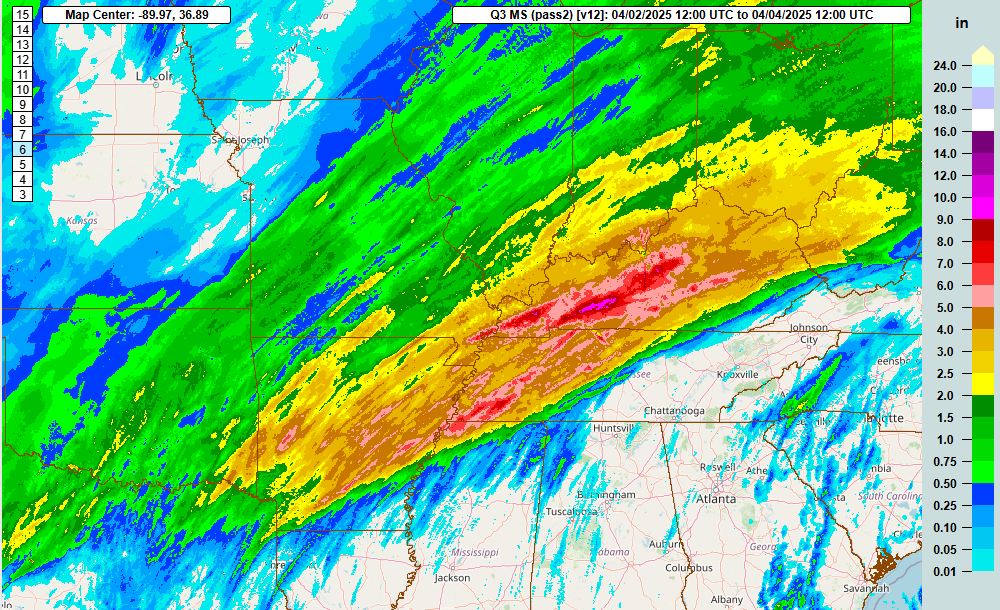
So now that we have talked through the warmth and the science of how it connects to all of this active weather, let’s talk about the weather itself. The MRMS 2-day rainfall estimate product shows that a large area from the Arklatex through the Tennessee and Ohio Valleys has had 2.5+” of rain, with several areas of 5+”. A particularly hard hit area has been Kentucky where the largest swath of 5-10” of rain has fallen.
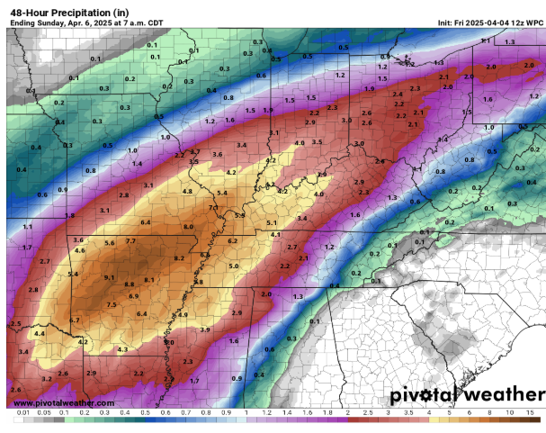
Unfortunately, the next 24 to 36 hours will be the peak of this heavy rainfall event. As the main weather system we have been talking about over the Southwest US finally starts to slowly eject out to the east, it will interact with the record moisture we discussed to support multiple rounds of intense thunderstorms producing very heavy rainfall. There has been a subtle shift to the west/northwest in the model forecasts over the last day or so in the axis of heaviest rain during the period, with Arkansas into the lower Ohio Valley being ground zero for a widespread 5-10” of additional rain.(high resolution models suggest localized swaths of 10-15” of additional rainfall). Even surrounding this area though, much of the mid-South and Tennessee Valley are anticipating additional widespread rainfall amounts of 3-6” on top of the rains that fell above, bringing totals for the event in many locations to 6-12”. All of this will support widespread major river flooding.
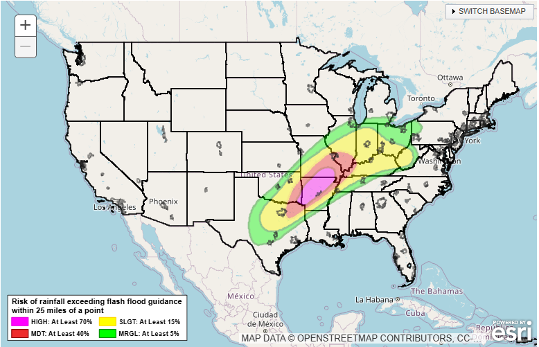
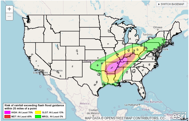
While flash flooding has already been pretty significant in the region the last couple of days, this risk will grow significantly in the next 24 hours as the more intense thunderstorms develop. Flash flooding is greatly exacerbated by higher rainfall rates, and more intense storms with the record moisture content we talked about can produce extreme rainfall rates. When you put the anticipated rainfall rates of the next couple of days over locations that have already seen very heavy rainfall over the last couple of days – and in many areas which have terrain which can help funnel flash floods – the stage is set for a risk of potentially catastrophic flash flooding over a large area. WPC has outlooked rare high risks – level 4 of 4 – of flash flooding accordingly for both Friday and Saturday in this region.
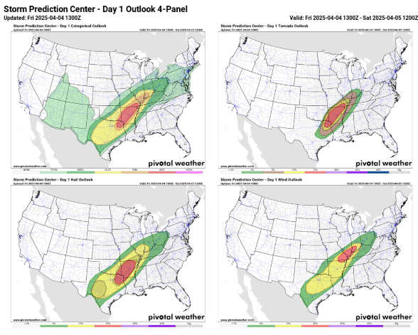
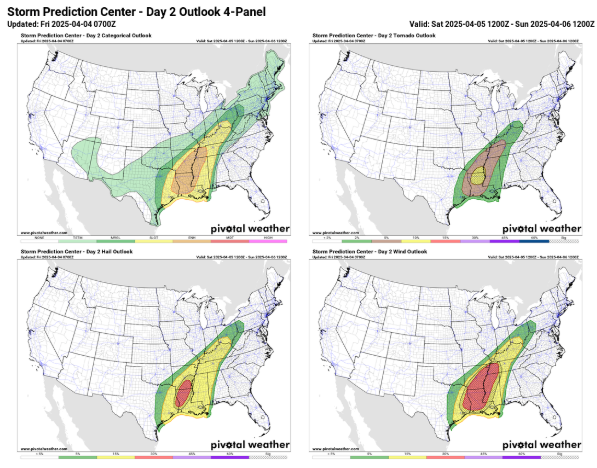
Severe thunderstorms will also be a real concern the next couple of days as well. SPC has a moderate risk (level 4 of 5) for severe storms today and tonight from the Arklatex across much of Arkansas. As has been the case the last several days, the atmosphere will have plenty of wind shear and instability to support numerous supercell thunderstorms in this region capable of very large hail, significant tornadoes and damaging winds this afternoon and tonight. This risk will shift to the mid-South and lower Mississippi Valley region on Saturday where an enhanced risk (level 3 of 5) is in effect.
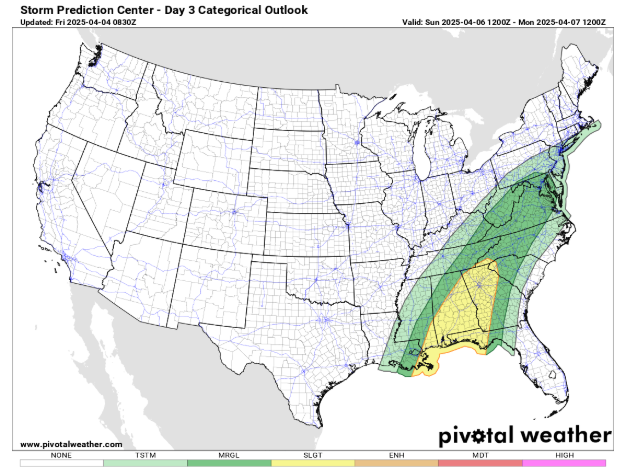
By Sunday, the overall weather system that has been supporting the active weather will begin to significantly weaken as a new strong upper level trough drops south out of eastern Canada, dramatically changing the weather pattern over North America. While there will be a slight risk of severe storms over parts of the Gulf Coast and Southeast on Sunday, that risk will be much less than what we have seen the last several days.
By early next week, the pattern change will be fully in place, with much colder conditions across the Great Lakes and Midwest, spreading into the eastern states. Next week looks much quieter than what we have seen for the last several days.
Given the very busy weather, I am planning to continue to provide additional details and updates today and Saturday via special posts, Notes, live and recorded video briefings and real-time Substack chats. As I continue to better learn Substack and the subscriber base continues to grow (250+ free subscribers now, thanks!), the videos and chats will become paid subscriber benefits soon as outlined here.

Leave a comment