Severe weather and flash flooding significant risks
Welcome to a new work week! Not surprisingly for early May, it is looking to be a busy next few days in the southern United States with risks of severe weather and flash flooding, with more storms in the Northeast as well.
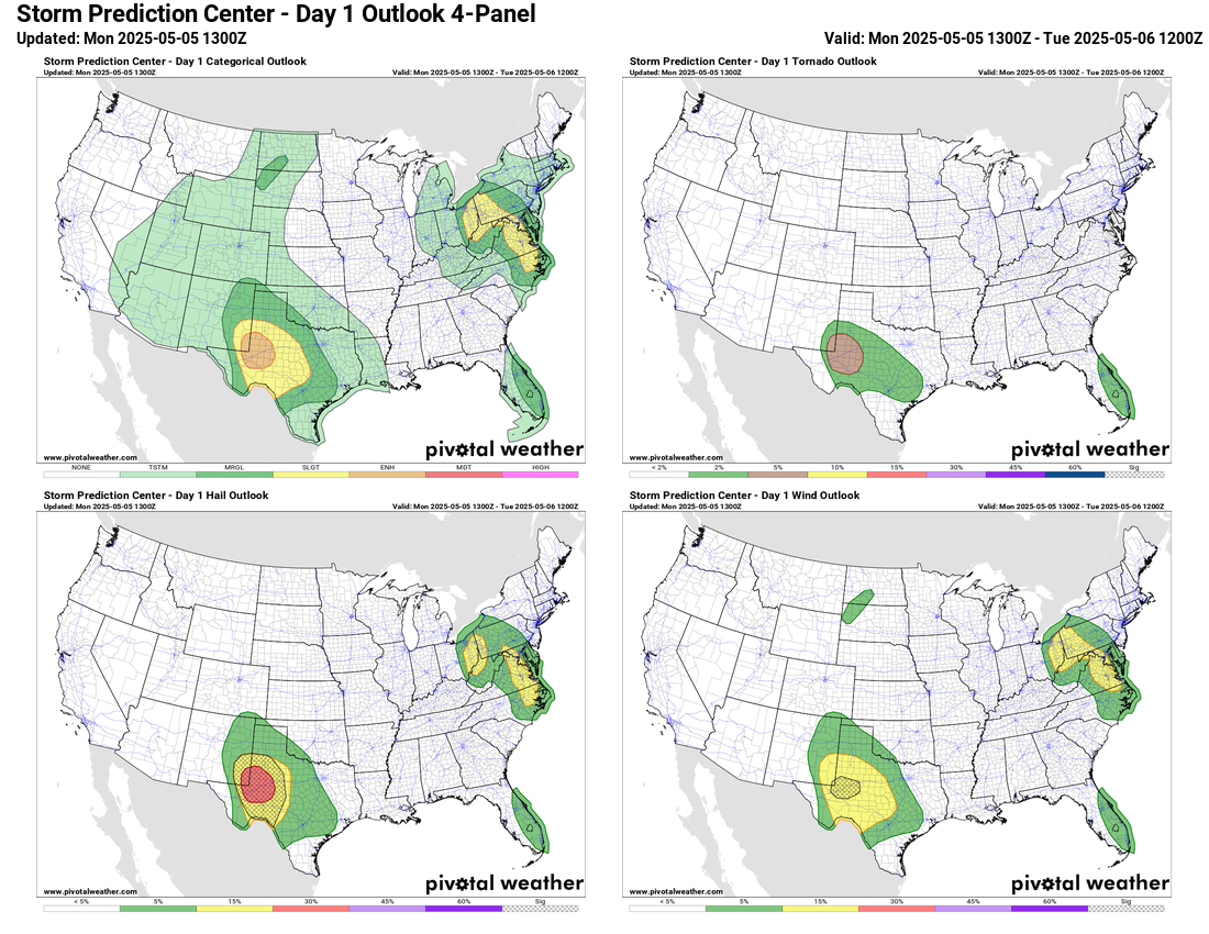
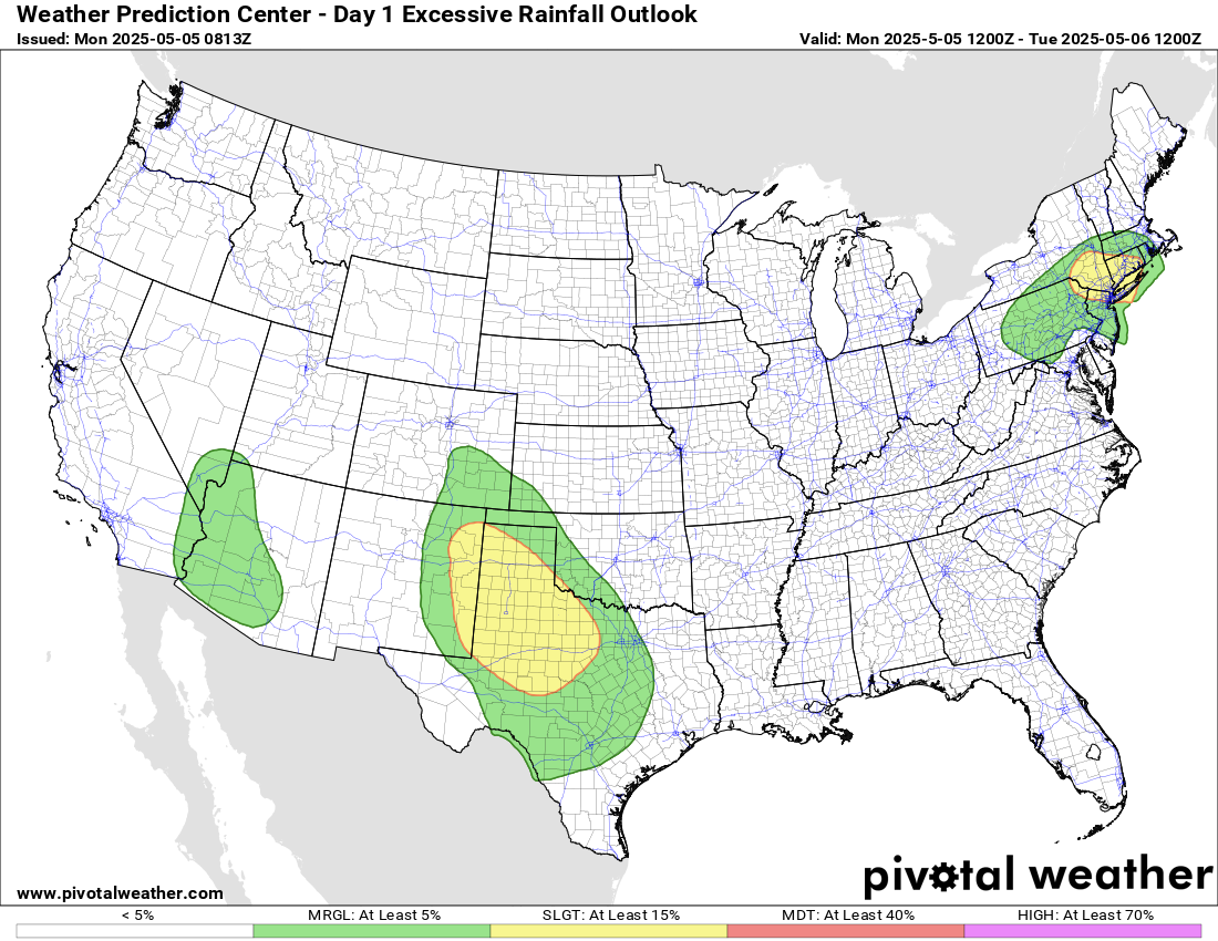
As we have been discussing the last few days, upper level low pressure systems over the Southwest and Ohio Valley will continue to the main weather producers early this week. The Ohio Valley system should bring another wave of showers and scattered strong to severe thunderstorms to the upper Ohio Valley and Mid-Atlantic. SPC has a slight (level 2 of 5) risk of severe storms for this region, with damaging winds and hail the primary risks. Farther northeast toward the New York City metro area, conditions will be less favorable for severe storms, but heavier rainfall in recent days is starting to make conditions a bit more favorable for flash flooding from downpour producing showers and thunderstorms. The Weather Prediction Center has placed a slight (level 2 of 4) risk for flash flooding here.
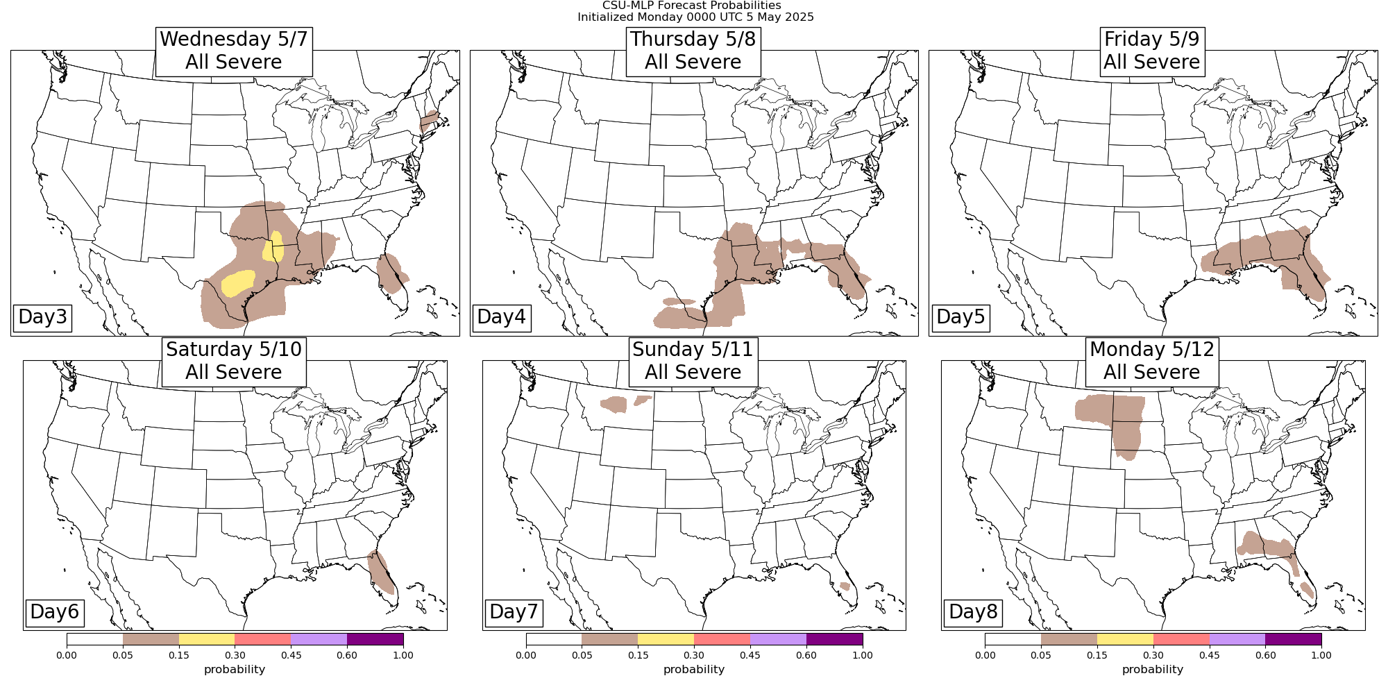
Farther west, the Southwest upper level low will start to make it far enough east to begin interacting with moisture and instability coming northwest out of the Gulf. By this evening, the atmosphere across west Texas and southeast New Mexico will become very unstable, and the upper low moves far enough east, several intense supercell severe storms are expected to develop and move northeast across this region. Very large hail, tornadoes and damaging winds will be possible with these storms, and SPC has an enhanced (level 3 of 5) risk of severe storms for this area. Additionally, locally heavy rainfall will result in a slight (level 2 of 4) risk of flash flooding.
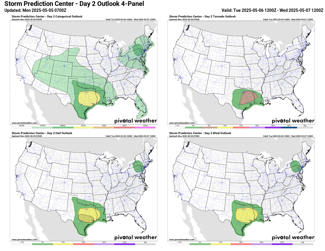
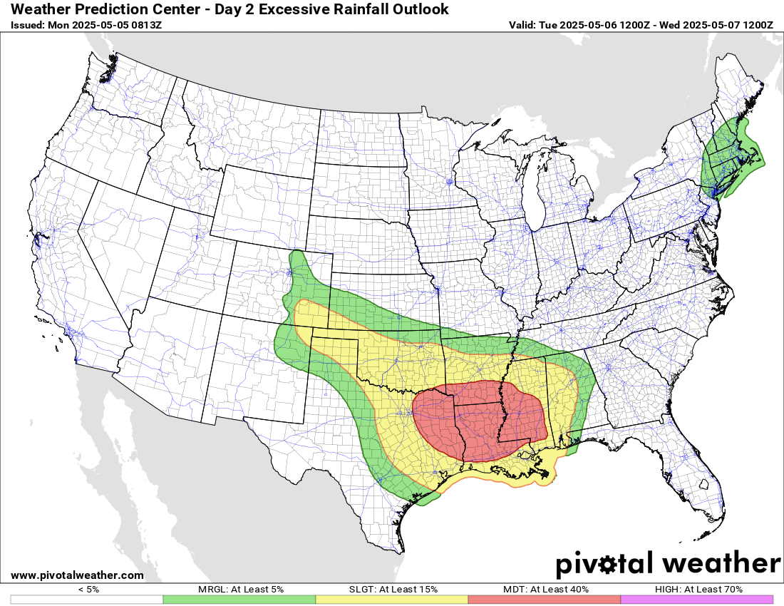
On Tuesday, the Southwest upper low will continue to slowly move east and the hazardous weather risk will shift east accordingly. Flash flooding will become an increasing risk tomorrow as Gulf moisture continues to increase and storms begin to move across areas that have had heavy rain over the last several weeks. WPC has placed a moderate (level 3 of 4) risk of flash flooding from the Arklatex across Mississippi. High resolution models this morning suggest there will be a west to east axis of very heavy rainfall – potentially greater than 5” – somewhere across this area tomorrow afternoon and evening. However, the exact location will be dependent upon how storms evolve over the next 24 hours.
In addition to the flash flooding, there looks to be a risk of more significant severe weather in the same general region, with the potential for tornadoes and very large hail from supercell storms. Similar to the flash flood risk, the exact corridor for the higher severe weather risk is uncertain and dependent upon storm evolution the next 24 hours, so for now SPC has a rather large slight (level 2 of 5) risk outlooked.
The eastern upper level low will be weakening as it starts to move a bit more quickly east. This will mean the risk of severe weather and flash flooding will be lessening in this region, but there will still be marginal risks of severe storms and excessive rainfall.
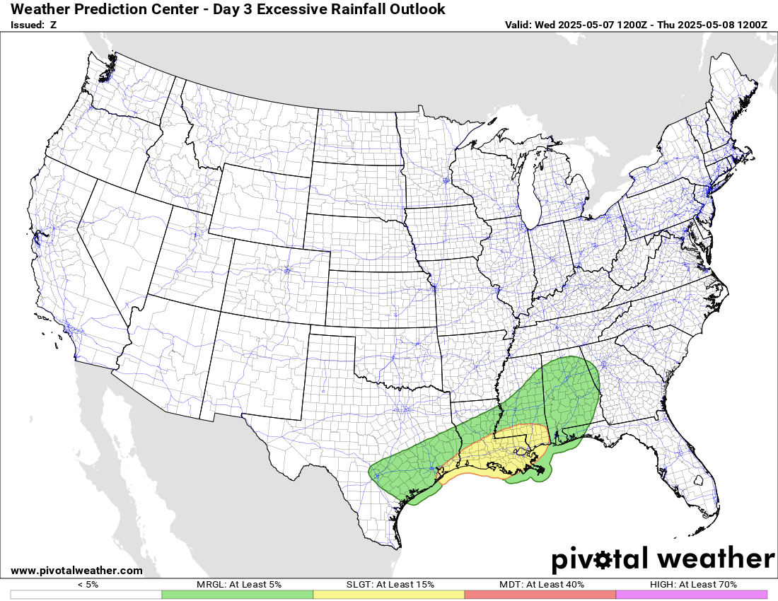
Beyond Tuesday, it still looks like the eastern upper low will move off the east coast, but be replaced by another upper level system dropping south of Canada which will eventually bring cooler and unsettled weather again late this week. Meanwhile, the western upper low will move east-southeast and impact the Southeast into Florida with increased coverage of showers and thunderstorms late this week into the weekend. While this does not look like a major severe weather risk, there will likely be some strong to isolated severe storms each day especially in the afternoon and evening. A more focused risk of heavy rainfall along the central Gulf Coast on Wednesday and Thursday will likely give way to more isolated locally heavy rainfall the remainder of the week.
Over the western United States, as the upper low exits to the east, a large ridge of high pressure aloft will develop across the region, bringing warmer and drier conditions. By this weekend some record high temperatures will be possible.

Leave a comment