Major coastal impacts for the East with serious flash flooding risks in the Southwest. Also, a deep dive into the state of the NWS upper air network in Alaska.
Oct 10, 2025
Happy Friday! It looks like a busy weekend of weather, but before I dive into that, I wanted to follow-up on yesterday’s post in which I discussed the complex upper level flow pattern across the Northern Hemisphere that will be driving our weather for the next several days. I talked about how Typhoon Halong will be recurving and moving toward Alaska as it transitions into a strong extratropical low pressure system, how that will result in significant changes to the downstream weather pattern over the rest of North America, and that the models often struggle with handling these situations.
The models struggle with the pattern shifts brought by these recurving western Pacific typhoons in “normal” times, and now we have the added complication of missing upper air observations due to the poor NOAA/NWS budget situation. I (and others) have talked quite a bit about the situation with missing upper air balloon flights over the continental US (CONUS), but there are similar problems outside of the CONUS.
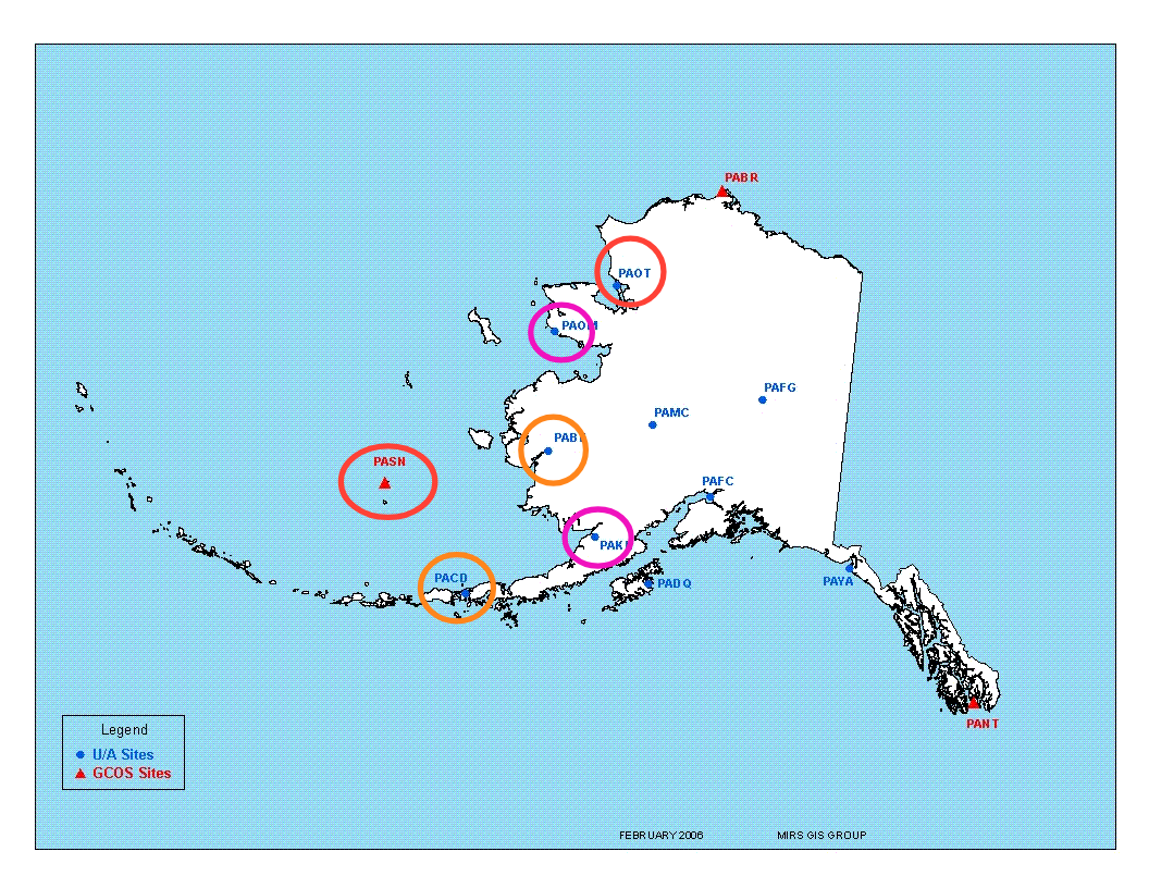
This is a map of the upper air observation sites in Alaska — there are 13 to cover its large expanse. Rick Thoman, a longtime (now retired) NWS meteorologist in Alaska who is now affiliated with the University of Alaska-Fairbanks Alaska Center for Climate Assessment and Preparedness and does a great Alaska and Arctic climate Substack, provided me with the latest status of the upper air network in the 49th state. I have highlighted sites with completely discontinued flights in red, once per day flights in orange, and sites with frequently missing flights in purple. Nearly half of Alaska’s network is degraded in some way, and unfortunately the impacted sites are all concentrated in the western part of the state.
As with all of these missing upper air sites, discerning how much impact there is on the model forecasts is difficult. However, this is a region of the world that already suffers from sparse data, and missing key upper air information is almost certainly causing some degradation. Rick noted to me that the completely missing upper air data from St. Paul Island and Kotzebue is certainly not helping the models handle the forecasts for a recent high impact storm that caused serious coastal flooding along the west coast of Alaska earlier in the week and the weekend forecast for former Typhoon Halong.
People in Alaska are particularly reliant upon accurate weather information given frequent hazardous weather events and extensive reliance upon aviation and marine transportation, so anything that might negatively impact forecasts there is of extra concern. Plus as we get into the fall and winter, situations like we have with Halong where weather systems impacting Alaska can have major downstream implications for forecasts in the CONUS also become more frequent. Hence, all of us should be concerned with the state of the NWS upper air network in Alaska, and I will be watching it closely along with the state of the CONUS network as we move into winter.
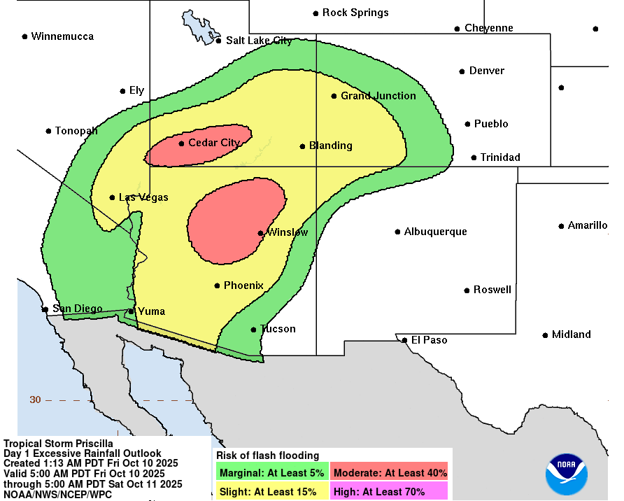
Meteorologists will be relying on those computer model forecasts to help deal with a plethora of high impact weather across the United States the next several days. I want to first focus on the significant flash flood risk in the Southwest associated with moisture from eastern Pacific Tropical Storm Priscilla. The risk is expected to significantly increase today particularly across the mountains of northern and central Arizona and southern Utah where the Weather Prediction Center has a moderate (level 3 of 4) risk of flash flooding in place for today.
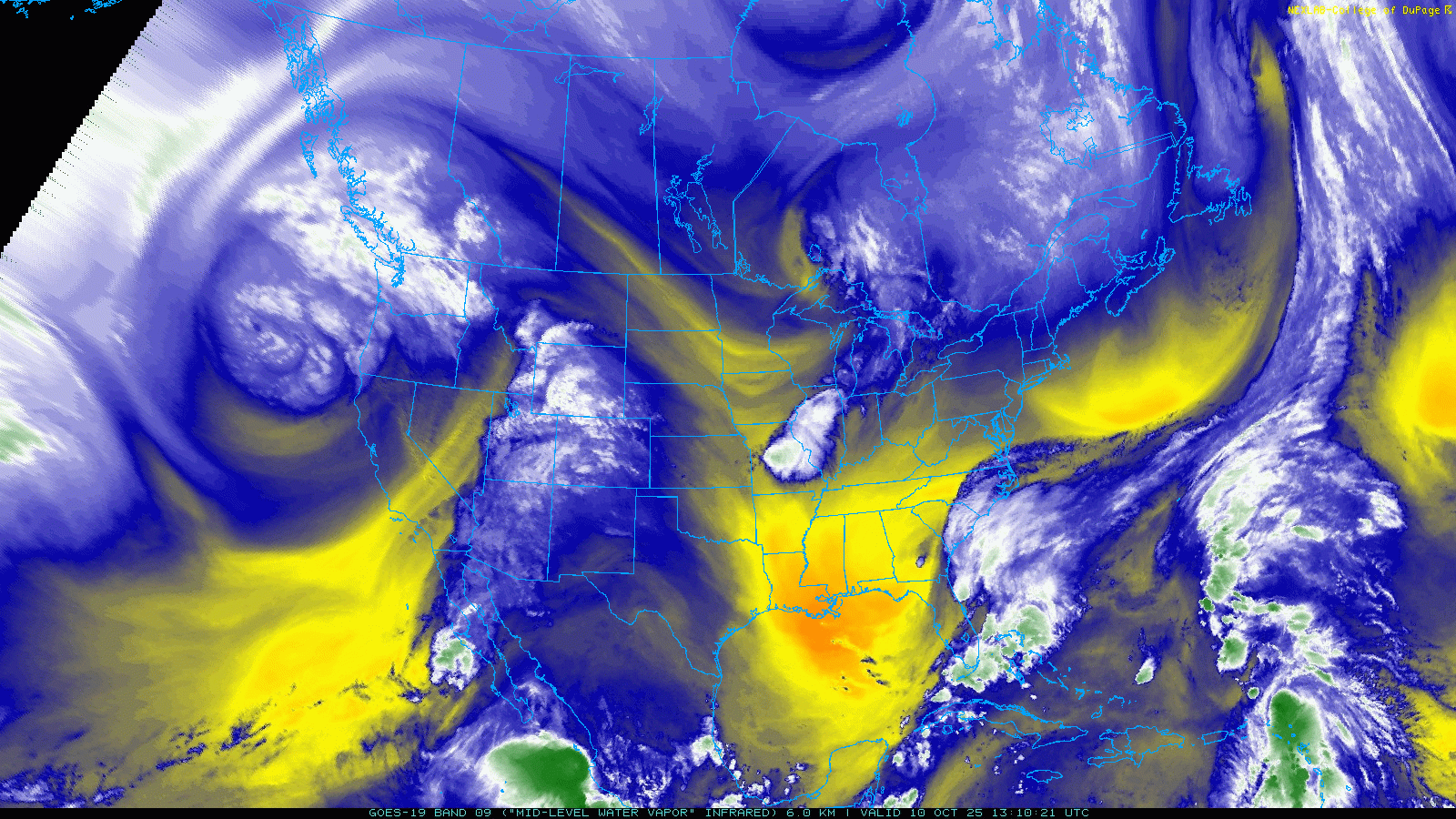
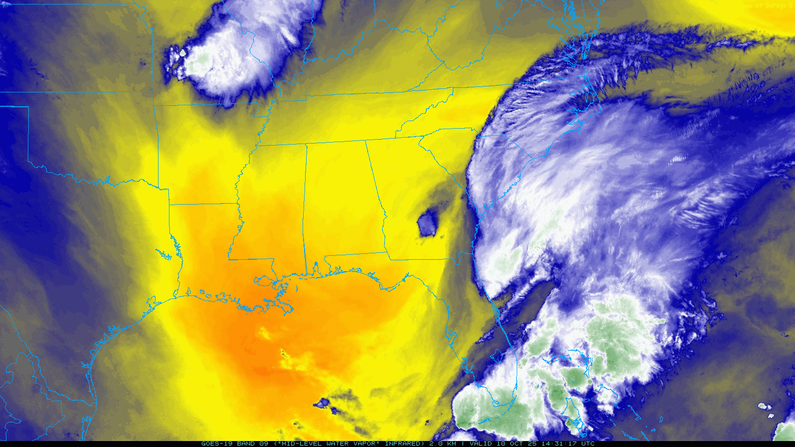
A loop of the GOES satellite water vapor product helps us visualize the features in middle and upper levels of the atmosphere that are driving this flash flood risk. A deep upper level low pressure system is swirling off the West Coast, and southwesterly flow ahead of that system is pulling moisture from weakening Tropical Storm Priscilla near Baja California and streaming it north and northeast into the Four Corners region.
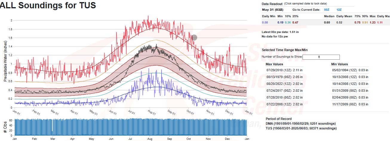
The Storm Prediction Center’s upper air observation climatology page shows that the precipitable water value at Tucson (gray dot on image above) is at a record level for the day (1.61”), confirming that extreme moisture will be available as thunderstorms develop across the Southwest and Four Corners in the southwest mid and upper level flow ahead of the West Coast low pressure system.
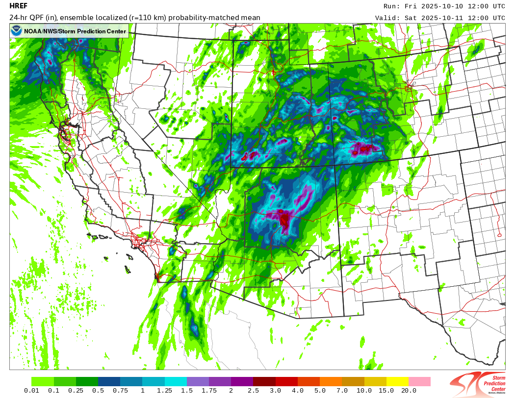
The most recent run of our short term High Resolution Ensemble Forecast (HREF) system shows that these storms will produce very heavy rainfall for this normally dry region, with localized amounts of up to 5” in the mountains of northern Arizona, southern Utah and southwest Colorado. Much of this rain could fall from thunderstorms in just a few hours, and given the terrain serious impactful flash flooding could result depending on where the heaviest rain falls.
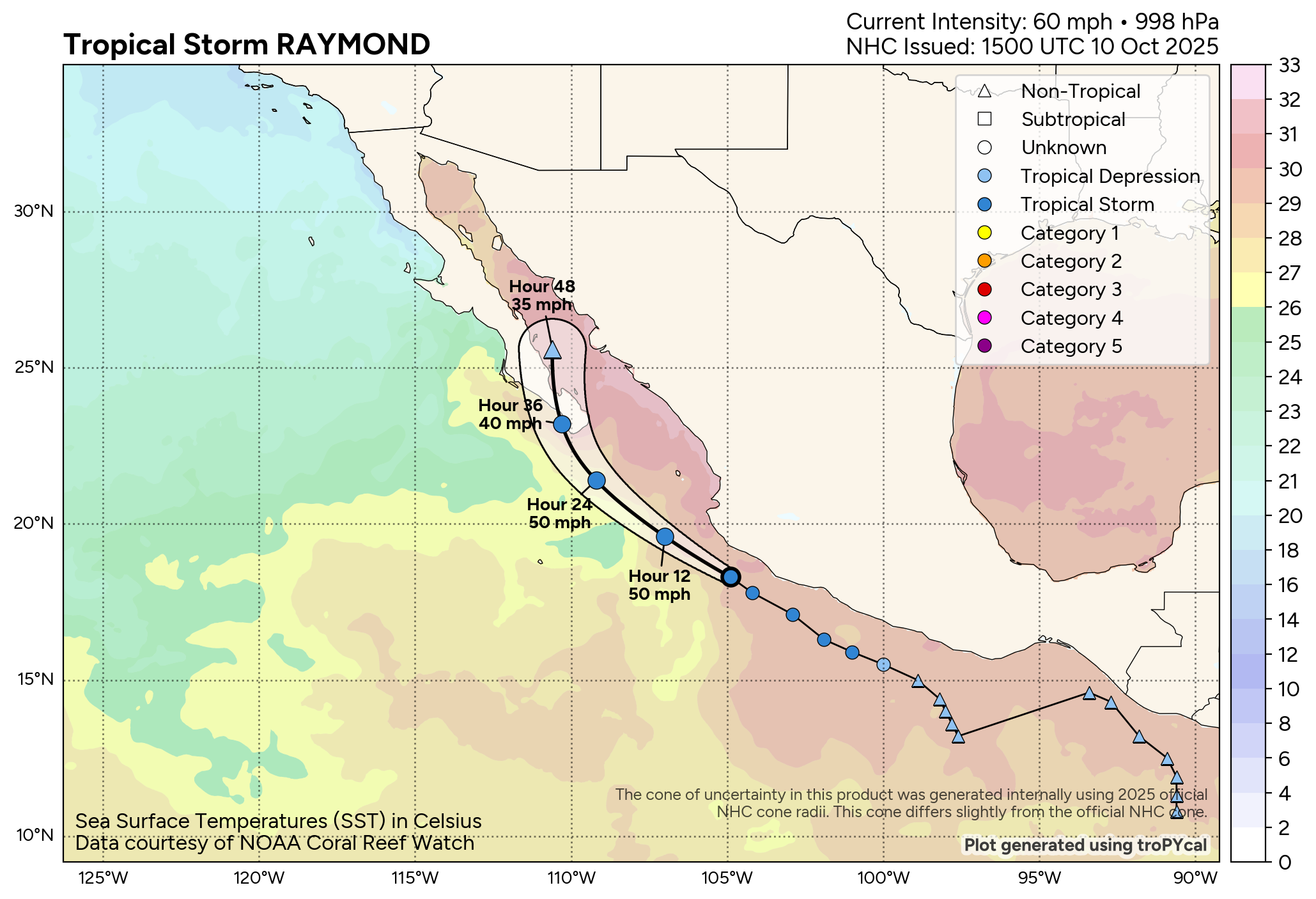
The overall weather pattern will be rather stagnant, and as Tropical Storm Raymond moves northwest off the west coast of Mexico toward Baja California (shown above), additional tropical moisture will be pulled north and northeast into the Southwest.
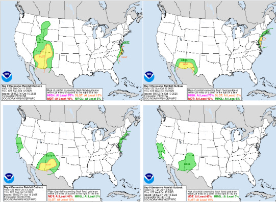
As a result, a significant risk of flash flooding will continue over the Southwest the next several days (current WPC days 2-5 flash flood outlooks shown above).
Meanwhile, while uncertainty still remains, the forecast scenario for the major impact East Coast storm this weekend is getting somewhat clearer. Water vapor satellite imagery this morning shows a deepening upper level trough of low pressure across the southeast United States, which is resulting in the development of a low pressure system at the surface as shown by the developing thunderstorm activity in the vicinity of the Straits of Florida and the Bahamas.
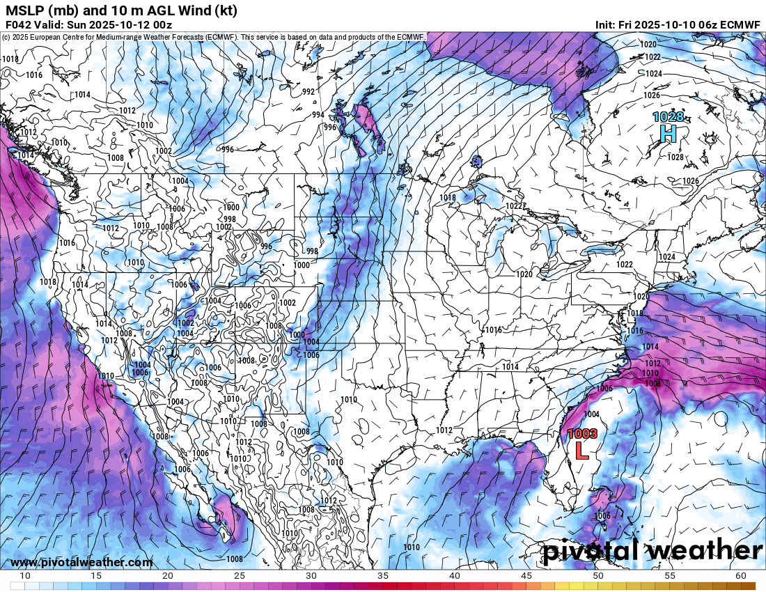
This developing low should move slowly north off the east coast of Florida the next 36 hours, and the flow between the low and a strengthening high pressure center centered over southeast Canada will bring increasing east to northeast winds along the coast from Georgia to North Carolina (European model forecast of surface pressure and wind for Saturday evening shown above for illustrative purposes).
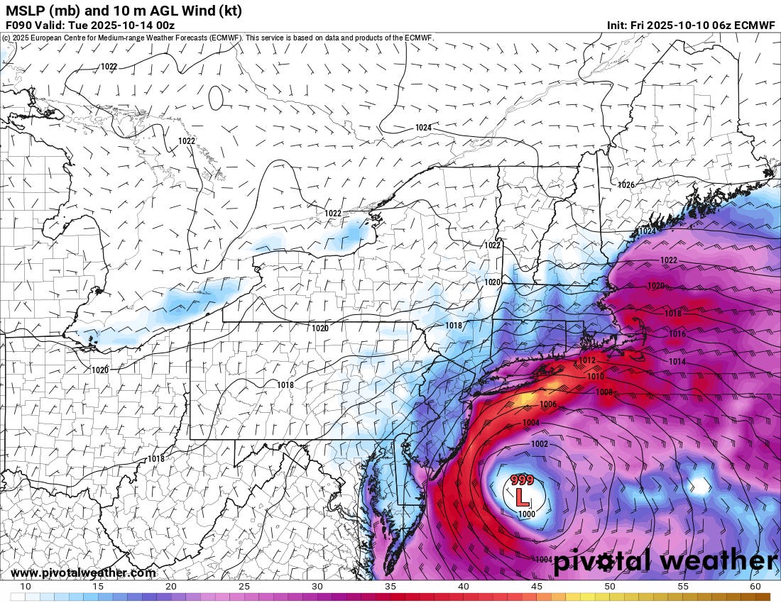
As we go into Sunday (European forecast for Sunday evening above), the low should tend to reform and intensify farther to the north and the high pressure to the north will also continue to strengthen, and this will result in even strong east to northeast winds developing from coastal North Carolina north along the entire East Coast up through New England.
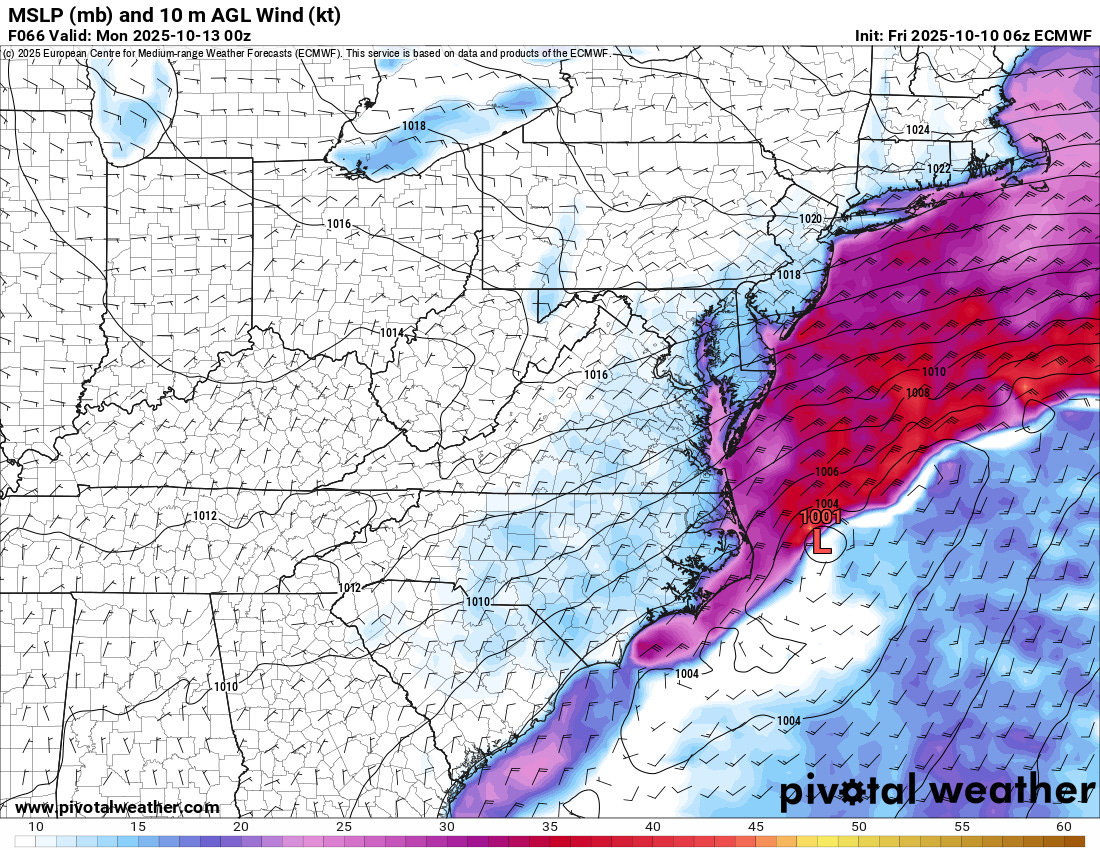
By Monday the low looks to consolidate off the Delmarva, which would bring particularly intense winds and coastal flooding to areas from New Jersey to southern New England (Monday evening European model forecast above).
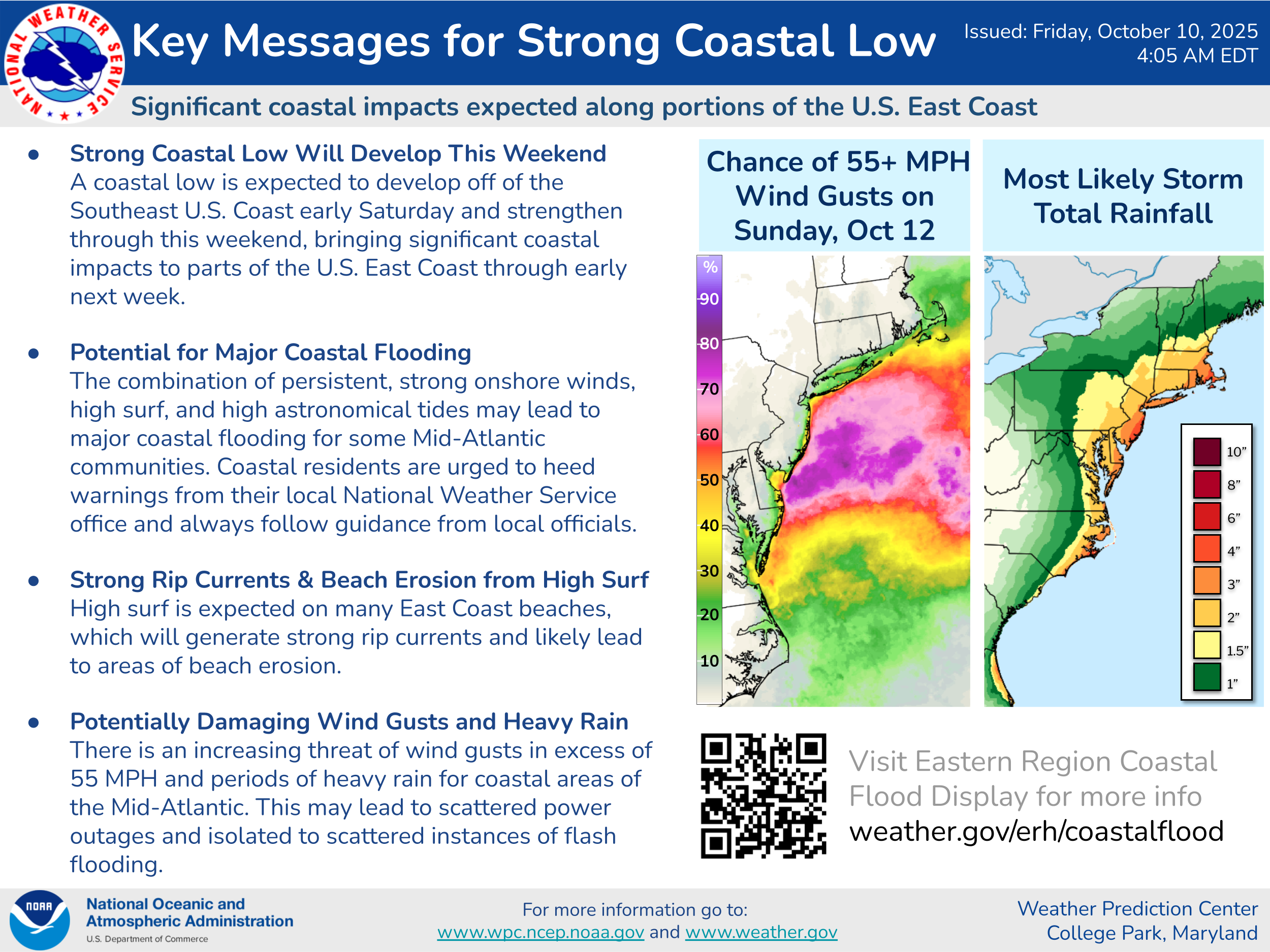
While uncertainty in the timing and details certainly persist, it does seem increasingly likely that this will be a high impact event, with the potential for major coastal flooding and wind gusts greater than 50 mph that could cause power outages up and down the Atlantic seaboard. Heavy rainfall is also likely, which could result in greater flooding impacts from the combination of coastal flooding and heavy rainfall. The models continue to hint at the possibility that the storm system could eventually obtain subtropical or tropical characteristics as it is over warm water for several days, but it is important to recognize that the impacts will not be any different regardless of whether this is a tropical or non-tropical low pressure system.
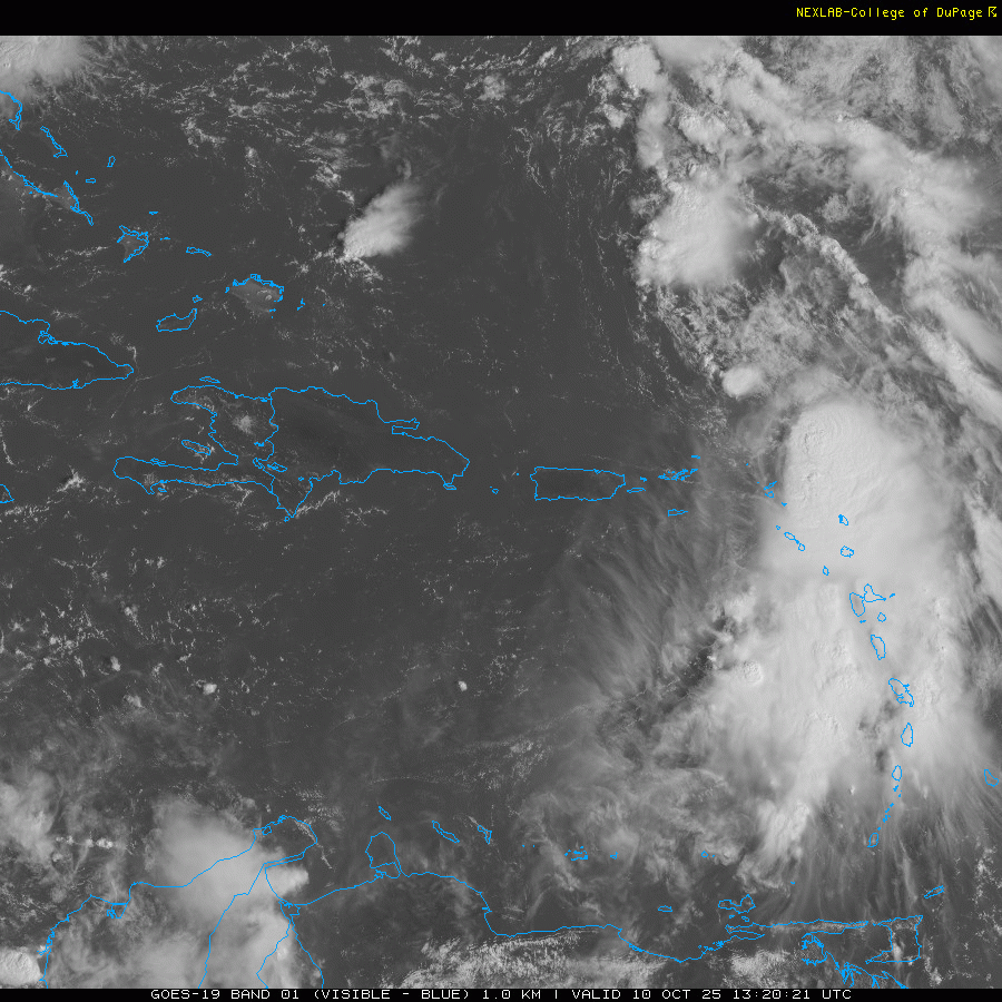
Tropical Storm Jerry continues to struggle with wind shear and has now weakened to a 50 mph storm — NHC is no longer is forecasting it to reach hurricane intensity.
![[Key Messages]](https://substackcdn.com/image/fetch/$s_!8HoL!,f_auto,q_auto:good,fl_progressive:steep/https%3A%2F%2Fsubstack-post-media.s3.amazonaws.com%2Fpublic%2Fimages%2F72154de7-e053-4aff-95dc-08392180c2ab_897x736.png "[Key Messages]")
Most of the thunderstorm activity continues well to the southeast of the center due to the wind shear, and as expected this has meant that the worst weather in the northeast Caribbean islands is happening now after the center has moved past the region. Flash flooding will remain a significant concern for the next 24 hours. The forecast track has shifted west a bit closer to Bermuda, but as of now most of the models keep it southeast of the island.
Finally, we now have Subtropical Storm Karen northwest of the Azores in the far northeast Atlantic. My colleague Michael Lowry has a good discussion in his morning Substack post about how unusual it is for a subtropical or tropical storm to develop this far northeast (TLDR: it is very unusual).

Leave a comment