Event raises questions again about missing NWS upper air data. Meanwhile, Typhoon Sinlaku pummels Northern Mariana Islands as it slowly turns north.
Apr 14, 2026
Lots and lots of weather to talk about today — let’s start with a quick update on Typhoon Sinlaku.
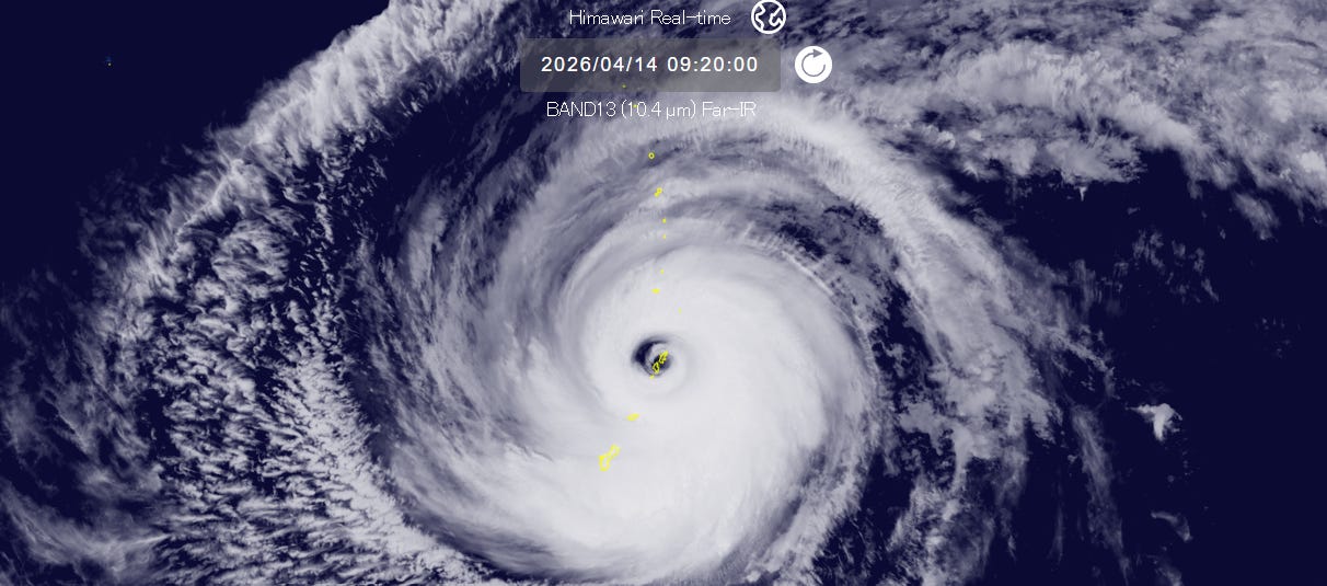
This incredible infrared satellite image from 4:20 am CT shows the islands of Saipan and Tinian completely enveloped by the large eye of Typhoon Sinlaku. As expected, an ongoing eyewall replacement cycle has resulted in some weakening of Sinlaku, and it remains a powerful storm with maximum sustained winds of 145 mph, equivalent to a category 4 hurricane on the Saffir-Simpson Hurricane Wind Scale.
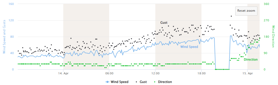
Unfortunately, Sinlaku’s forward motion has significantly slowed in the last 18 hours, and it is currently only moving northwest at about 5 mph. This slowing down right as the typhoon’s core was approaching Tinian and Saipan has resulted in an incredibly prolonged period of intense typhoon conditions. The graph above shows the sustained winds (blue line) and gusts (black dots) at Saipan International Airport (data is missing for a couple of hours Tuesday evening local time). It shows that Saipan experienced sustained hurricane force winds for at least 9 hours with frequent gusts over 100 mph, with a peak wind gust of 130 mph. Torrential rain has also been occurring — the rain gauge at the airport has reported over 6”, but that is likely significantly underestimated as the strong winds are likely resulting in horizontally blown rain missing the rain gauge, a phenomenon seen in other hurricanes and typhoons known as “undercatch.”
While likely not as extreme as during the approach of Sinlaku, Tinian and Saipan still have many hours of high end tropical storm and at time typhoon conditions to deal with on the backside of the system as Sinlaku only slowly pulls away.
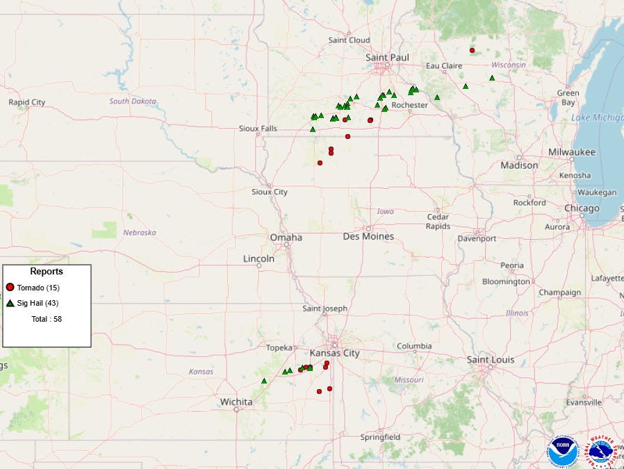
Turning to severe weather, yesterday saw two focused areas that supercell severe storms with tornadoes and very large hail impacted. One was the anticipated area from northern Iowa into west central Wisconsin — the other was a completely unanticipated area in east central Kansas where tornadoes caused significant damage south and southwest of Kansas City.
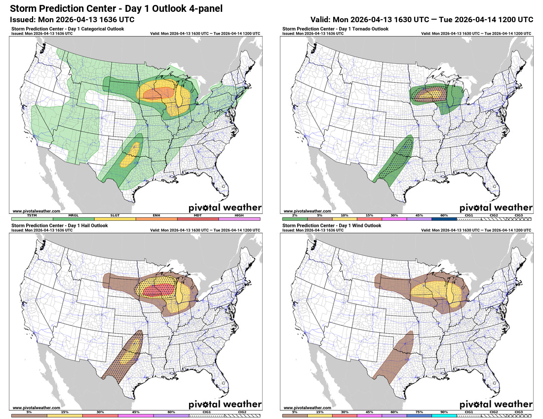
If we look at yesterday’s late morning outlook from the NWS Storm Prediction Center (SPC), this area was not in even a marginal risk of severe storms. A risk area was not added until the evening update once the storms had developed.
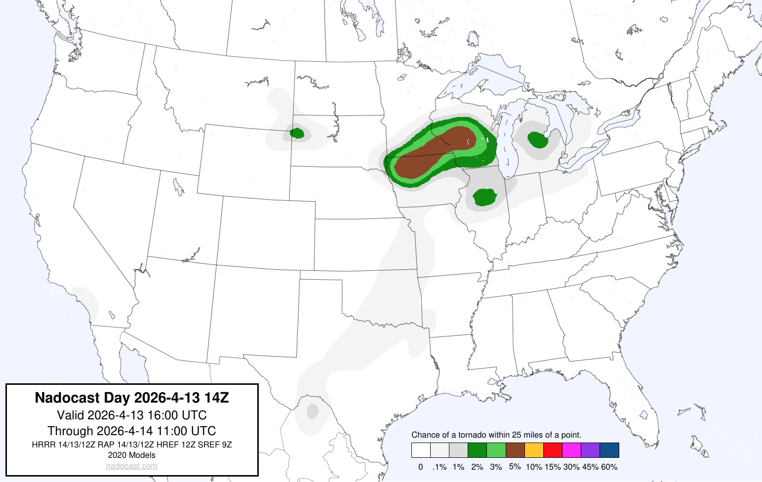
To be clear, the AI systems such as Nadocast also did not have any meaningful risk of tornadic supercells in this region either. From taking a quick look back at the atmospheric setup and reading forecast discussions from local NWS offices, while the atmosphere was expected to be conducive for severe storms with unstable air and wind shear, there was little in the way of any sort of triggering mechanism for storm initiation seen in the models or observations, and the probability of precipitation was generally around 10% or lower.
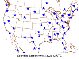
I have not talked as much recently about the issues with missing NWS upper air balloon data. While it has improved from the worst of the situation back in mid-2025, it has remained a significant issue in Alaska and a large number of sites in the US continue to defer their typical early morning balloon release at 1200 UTC to a midday release due to staffing issues. The map above shows the NWS locations that had a balloon release at 1200 UTC on Monday, and there is clearly a huge swath of missing data from the Southwest through the Plains.
The potential role of this missing upper air data in the poor Kansas severe weather forecast has been a topic of conversation among meteorologists on social media since the tornadoes occurred last night. While we do have many other sources of upper air data such as satellite and aircraft data, upper air balloon data still plays a huge role in the models and forecasts. I just cannot look at that map with all of the missing data upstream from Kansas and not think it played a role in the almost complete dearth of robust thunderstorm development from any model forecast in this region — and a corresponding overforecast of convection over Oklahoma that did not materialize in the real world.
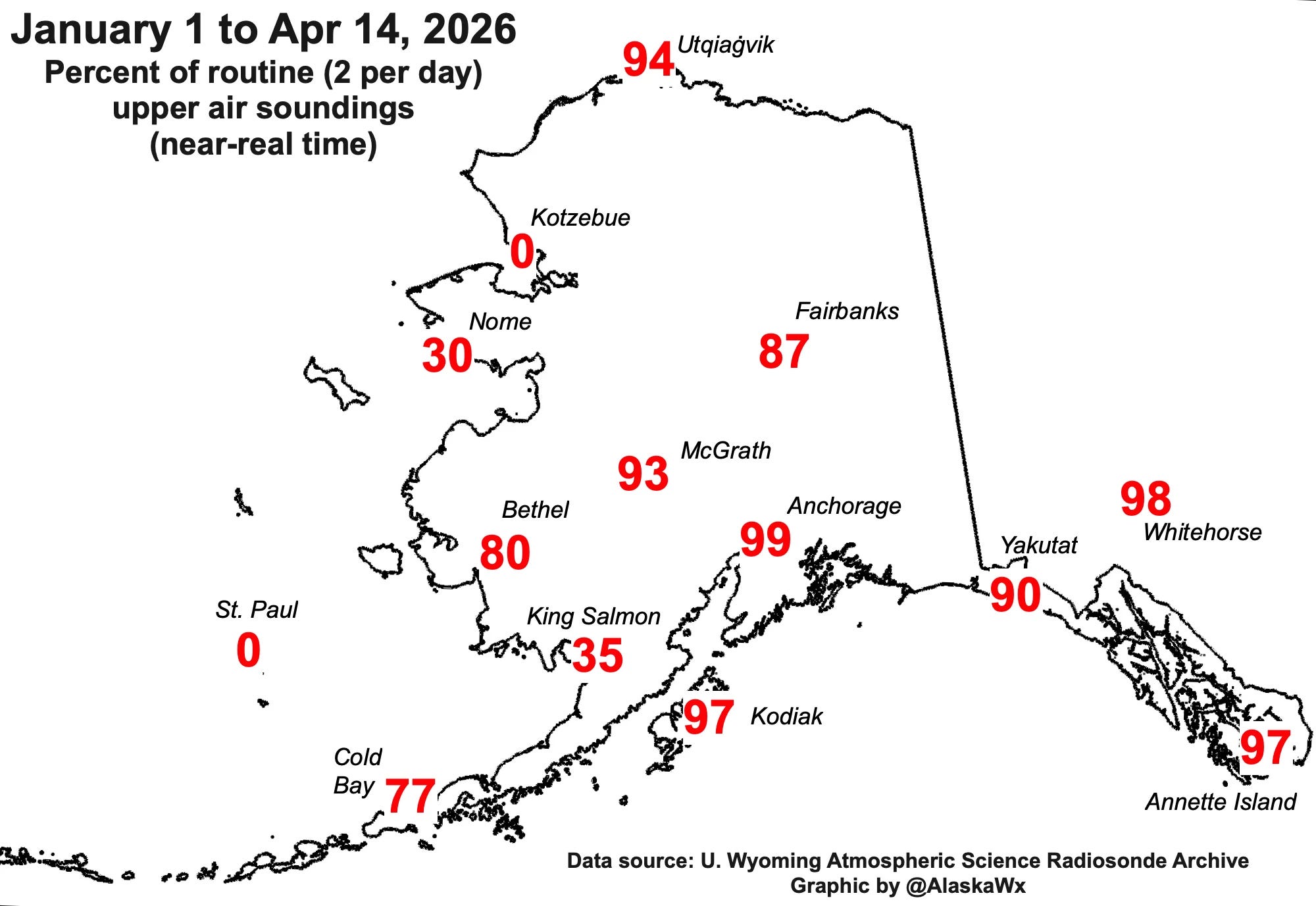
In my opinion, if the NWS is going to continue to utilize this staggered balloon release strategy, it is incumbent upon them to conduct scientific studies to determine how this strategy is impacting the models and NWS forecast services, as well as how continued upper air shortages in Alaska are affecting NWS services there (much thanks to Alaskan colleague Rick Thoman for his work above staying on top of the issues there). I recognize that NWS is under serious staffing and budget constraints (which is why they are pursuing this new upper air strategy in the first place), but it has become unacceptable for the meteorological community — and the public and key decision makers who rely upon it — to continue to face these hazardous weather events and wonder about how NWS services are being impacted.
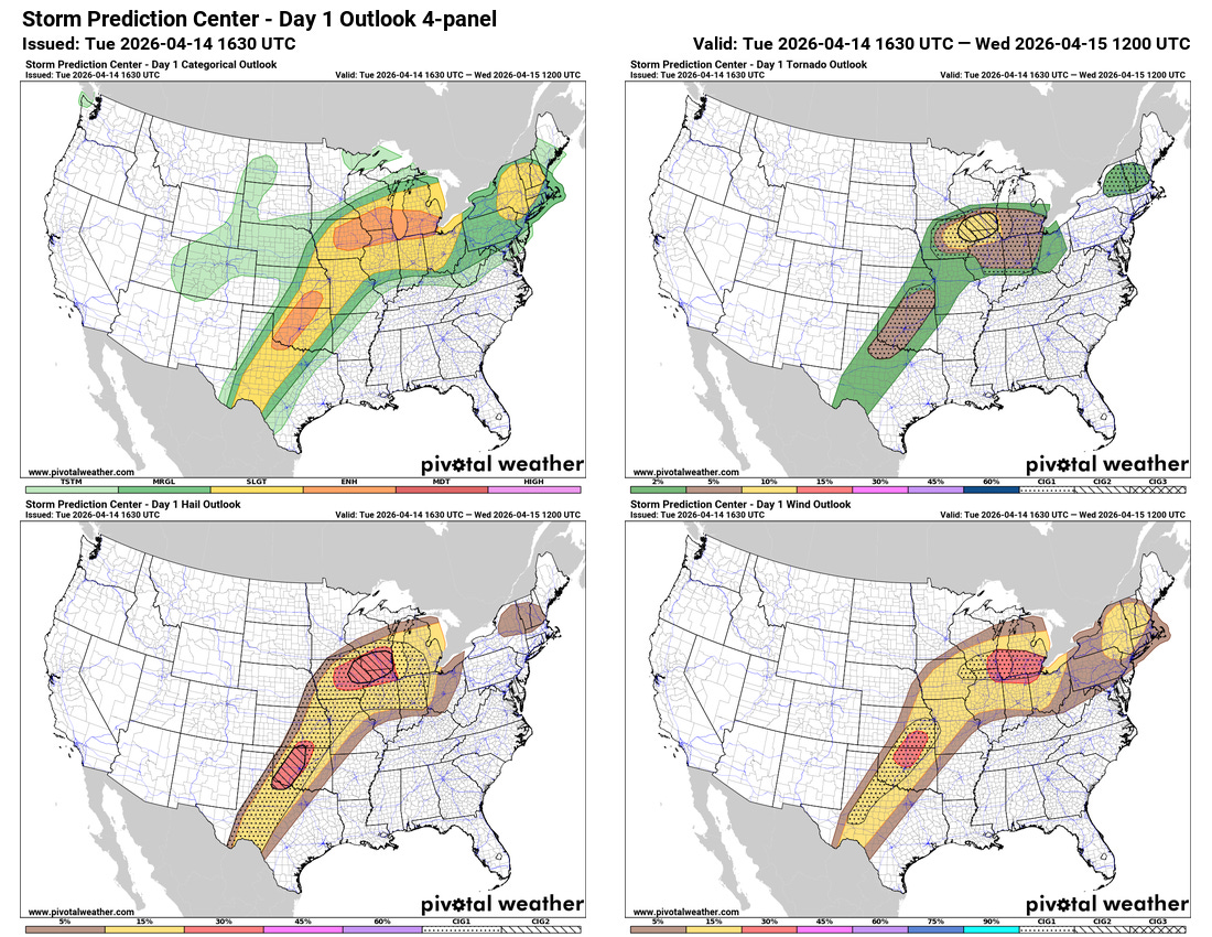
Today looks to be another active day of severe weather with two areas of focus for intense supercell development — one over the Upper Mississippi Valley and lower Great Lakes region, and the other in the Southern Plains. Both of these areas have been highlighted by SPC with enhanced (level 3 of 5), with level 2 (highest) “conditional intensity group” (CIG) for very large hail potential. A significant tornado risk will exist with supercells in both areas — but the threat looks to be maximized from eastern Iowa into northern Illinois and southern Wisconsin. Supercells moving east along a warm front in this area will have a particular risk for strong tornadoes, and SPC has placed a tornado level 2 CIG here indicating an elevated risk for EF3+ tornadoes.

Strong to severe storms are also expected this afternoon and evening over parts of the Northeast, and a severe thunderstorm watch may be needed her this afternoon.

A daily risk of severe weather is expected through the end of the week as shown by the NCAR AI severe weather probabilities based on the European ensemble forecast. Friday continues to look like a particularly active day with the potential for a more widespread high end severe weather event.
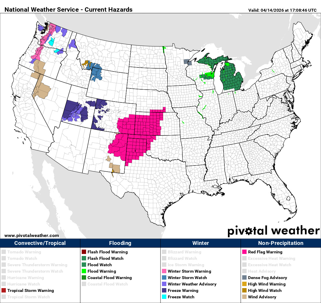
Fire danger is also a significant risk this week, with red flag warnings in effect for parts of the central and southern Plains today, and additional risks expected through the week as weather systems traverse across the region bringing dry, windy conditions. Elevated fire danger will also exist over parts of the East due to ongoing drought, record high temperatures and occasional breezy conditions. Some high elevation snows continue in parts of the West, bringing a bit of improvement to the extremely poor snowpacks in this region.
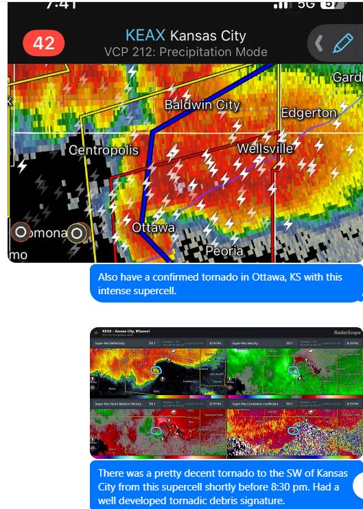
A reminder as we are in this active severe weather period that I am using Substack Chat to post occasional updates as well as share interesting storms and meteorological situations I see (example from last night above). This is in addition to more formal chats and videos on high impact weather days. Obviously given that I am a one man band, this is not something I can do all the time – but it is something I am trying to utilize to get more information out there and to provide a benefit for those folks who support Balanced Weather as paid subscribers.

Leave a comment