And an evening update on a potential severe weather outbreak Friday
Apr 16, 2026
You’re getting a rare full evening newsletter from me tonight for two reasons. First, I said earlier today that I would give more info about the busy weather in a video or post, and the video didn’t happen, so I’m posting. Secondly, and this is what I will start with, I have more information and perspective about the modeling and upper air balloon topic I talked about earlier today, and feel like I need to get that out before we get into busy severe weather the next 36 hours.
Thankfully today my post triggered a couple of kind souls to send me the link to the latest and greatest NWS Environmental Modeling Center (EMC) model verification webpage. I tried to find a more up to date site before I wrote my post today, and in my defense I know a lot of people who have had trouble finding it. Anyway, you can find it at https://www.emc.ncep.noaa.gov/users/verification/headlines/ and if you are a meteorologist or interested in weather models you should bookmark it because it has a lot of great information.
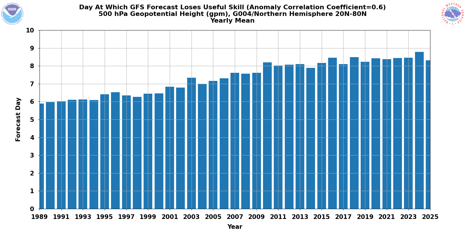
This is the basic model verification parameter that I think most people can best instinctively understand – useful skill day. Essentially, if a model had a perfect forecast of 500 millibar heights everywhere, it would have a correlation coefficient score of 1.0. When that correlation coefficient score drops below 0.6 over the Northern Hemisphere for a model, we say that model no longer has useful skill, i.e., it essentially is not producing a 500 millibar forecast that provides a meteorologist information that can provide a better forecast than climatology.
In the above graphic, we can see that in 1989 the NWS global model the GFS did not quite have useful skill out to day 6, while in 2025 it had useful skill out beyond day 8, obviously a significant improvement. However, we can also see that in 2025 the useful skill of the model actually notably decreased from 2024. In fact, the useful skill in 2025 looks about the same as it did in 2019. While the increase in skill has certainly been not linear since 1989 and there have been other years with decreases in skill from the previous year, I do not see another similar drop that implies a loss of 6 years of model progress.
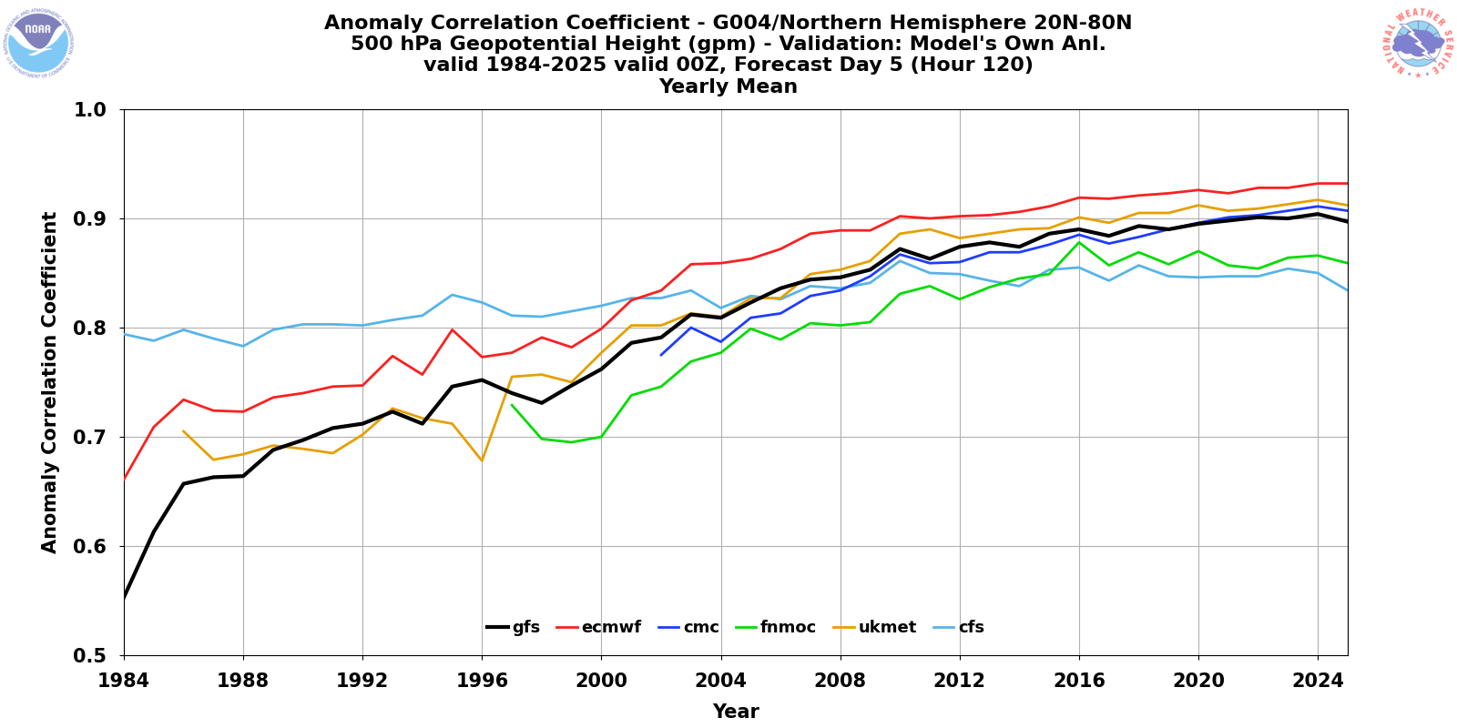
Given all of the talk about NWS upper air balloon issues in the last year, it would be easy to leap to the conclusion that this is a primary cause in the decrease in GFS verification scores. If in fact the cause is the upper air balloon data into the model, we would expect to see all of the global models to show similar decreases given that they are all ingesting the same data — although differences in how the each model assimilates that data could temper those trends. Interestingly — and to me, rather amazingly — the correlation scores actually do show such a decreasing trend for nearly all of the global models between 2024 and 2025, with the European Centre (ECMWF) essentially flat. Given that the ECMWF is generally recognized to have the best data assimilation scheme in global numerical weather prediction, it makes sense (to me, anyway) that it would show the least impact.
While these statistics are the most compelling data I have personally seen to this point suggesting the possibility that the NWS upper air changes and difficulties due to budget and staffing are having a measurable deleterious impact on the model forecasts, I want to stress again that it is not “proof.” There are plenty of other possible explanations, and while 500 millibar height correlation is kind of the “gold standard” parameter that modeling centers tend to focus on, there are a myriad of other important parameters that can be looked at. As a couple of my colleagues pointed out on social media today, the only really scientific way to answer this question of how the missing balloons and changed cadence of release time is affecting the models — global or high resolution/convective allowing — would be to perform data denial experiments where you run the model with a full set of upper air balloon data, rerun it with a number of upper air balloons removed, and compare the results. However, that is very time and resource consuming, and I am guessing the NWS does not currently have the resources to perform this work.
A number of my colleagues have pointed out to me both today and in recent months that the number of model busts both at a large scale and with smaller scale events seem to have been more numerous and pronounced in the last year — but whether that is just human perception because we know about the upper air data issues or actual reality is more or less impossible to know. However, given what can be seen in the actual verification data here, the NWS upper air data issues’ impact on the model forecasts is pretty clearly at a minimum a reasonable concern for the meterological community — and as I said this morning, until we can get more clarity, questions will continue to be asked about this topic when poor forecasts occur.
I do want to reiterate that this new (relatively, implemented in 2024) NWS model verification site has a lot of useful information. While the verification data from the high resolution models only goes back a few months, it is great to see that it is being collected and will enable at some point the community to be able to track year over year improvement to these models like we can with the GFS. The NWS is a public science and service agency, and as such transparency about its performance is crucial. I appreciate that this data is being shared to the public via this website.
I am once again opening up comments on this post to everyone. I want to stress in the interest of full transparency that numerical weather prediction (NWP) is a very specialized part of atmospheric science that I am by no means an expert in. I am giving my (hopefully) educated perspectives as an operational user of NWP data that has some basic expertise in NWP verification — anyone who has more specialized insight, or anyone who wants to ask questions about these topics, please comment below.
One other story I want to mention but do not have time to dig into is that the Associated Press reported today that President Trump and new DHS Secretary Markwayne Mullin plan to nominate Cameron Hamilton — who was fired as temporary director of FEMA last year — as permanent director of FEMA. Obviously, given that he was fired it is surprising that now he is in consideration for this role — as you may remember, he was fired because he contradicted President Trump and Secretary Kristi Noem by testifying to Congress that he believed FEMA was a needed agency. Certainly more to come on this story in coming days.

Turning now to weather as promised, today’s severe weather “overachieved” in the lower Ohio and Tennessee Valleys, as a line of severe storms moved across the region producing numerous wind damage reports and several incidences of very large hail. More than 100K customers lost power in Tennessee at one point due to the storms, and as of 930 pm CT about 85K remain without power.
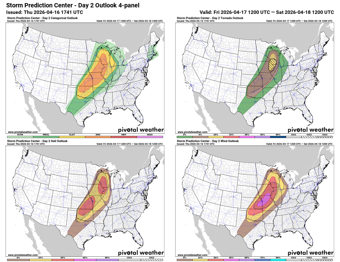
The evening high resolution models that have arrived so far do not do much to change the expectations as far as a potential outbreak of severe weather on Friday. The atmosphere looks to become very unstable over a large area ahead of a cold front and strong upper level trough of low pressure moving east out of the Rockies. Severe thunderstorms are expected to erupt along the front Friday afternoon and continue into Friday night.
The overall atmospheric setup suggest these storms will eventually form in a powerful line that will be capable of significant swaths of straight line wind damage — but while they remain more discrete, conditions look to be favorable for them to produce strong tornadoes and very large hail. This could occur anywhere in the enhanced (level 3 of 5 )risk area, but looks most likely over parts of the upper Mississippi Valley where the Storm Prediction Center added a “conditional instability group” level 2 area, suggesting an enhanced potential for EF3+ tornadoes. This area is now at the highest probabilistic level possible before moving up to a moderate (level 4 of 5) risk. Needless to say, people in these risk areas need to be paying extra close attention to the weather on Friday.
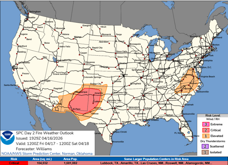
This system will also bring critical wildfire conditions to the southern High Plains, with strong westerly winds and very dry conditions.
More to come on all of this weather tomorrow.

Leave a comment