Severe weather risks remain elevated today across central US, and for East Coast on Sunday
Jun 13, 2026
Before I get into an anticipated weekend of active weather, I wanted to highlight that yesterday the New York Times focused their latest “Lost Science” piece on Dr. Amy McGovern and the National Science Foundation’s Artificial Intelligence for the Earth System (AI2ES). As I wrote about back in September, the Trump Administration abruptly terminated funding for AI2ES — an inaugural NSF AI institute focused on developing “trustworthy Artificial Intelligence (AI) methods for Earth system (ES) and environmental science” — with the Office of Management and Budget alleging that AI2ES “wasted taxpayer funds to place climate change hysteria in AI models.”
I know there is a lot of controversy surrounding AI in our society, but as many of my colleagues pointed out in sharing the NYT piece about AI2ES, atmospheric scientists have long recognized that meteorology problems are uniquely suited to attack by AI approaches. Heck, I was part of a research-to-operations project to use neural networks to improve quantitative precipitation forecasting at NWS Jackson in the late 1990s. Dr. McGovern explained all this to the Times:
I like to tell people I was doing A.I. before A.I. was cool. But really, I always knew I wanted to use artificial intelligence to make a difference in the real world. Back in 2005, when I first moved to Oklahoma and became a professor, I began studying how A.I. could be used to improve weather forecasts. Specifically, my research tries to improve predictions about extreme weather, like hurricanes, heat waves and snowstorms.
It’s a really hard problem that goes beyond whether or not you need to bring a coat or an umbrella today. It’s about whether or not you should evacuate from a tornado coming down your street in the next five minutes or the next 15 minutes. These are very high-stakes decision-making moments with a lot of uncertainty. But it’s a perfect problem for A.I. because there is a lot of weather data out there, and data is what A.I. is really good at making sense of. It reveals patterns that humans aren’t able to see and finds useful connections between different weather models.
In the last 20 years, what we can do with A.I. and forecasts has substantially changed. Now A.I. is actually informing forecasts made by government agencies and private sector companies, like the Weather Company, and the results are showing up on people’s phones.
I totally second what Dr. McGovern says in the last sentence. I have been completely amazed by how much progress — especially in the last 5 years — that has been made to develop AI tools, algorithms and models that are making real contributions to improve weather forecasts and warnings.

Just yesterday meteorologist Andrew Brady posted on X that his StormNet AI probabilistic severe weather guidance had the highest utility scores from forecasters during this year’s Spring Forecast Experiment in NOAA’s Hazardous Weather Testbed. Various AI tools that produce probabilistic severe weather guidance were evaluated in the HWT, and Google’s WxNext2 guidance was just behind StormNet in forecaster evaluations. Google’s AI team of course also developed the Google DeepMind (GDM) tropical cyclone guidance which is utilized operationally by the National Hurricane Center and which last year was found to have produced the most accurate forecast guidance for Atlantic tropical storms and hurricanes in 2025.
I look at these and many other AI based weather tools and models pretty much every day, and my own forecast process has become more and more based upon them as I can see their reliability and usefulness. While AI has been explored for its use in meteorological applications for many years, I think it is fair to say that the work has really ramped up in the last 5 years, and that many of these exciting new developments are relatively nascent and based on evolving AI approaches. There is no reason not to think that that improving computing, AI approaches, and meteorological understanding will only make these already highly promising tools even better in the coming years.
That is why the Trump Administration’s decision to terminate funding to AI2ES and reduce other meteorological research funding makes absolutely no sense. NSF has stated that AI research is one of the (few) scientific priorities of the administration. Meteorology is an area where AI can truly make tangible and rapid contributions to society — rather than throwing money away on tangents where AI’s potential are highly questionable, it would seem like we should be doubling down on investments where we already have extensive proof that AI can make a meaningful difference.
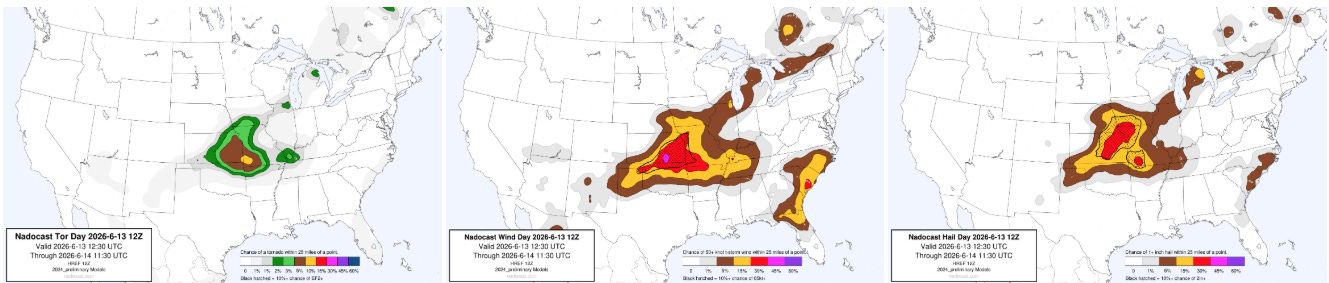
With all of this talk of AI tools, let’s take a look at one of those quite reliable sources of probabilistic severe weather guidance for today, Nadocast. A line of severe storms has been moving southeast across the Mid-Missouri Valley this morning, and it should essentially maintain itself or gradually weaken as it moves southeast this afternoon. Meanwhile, the atmosphere should become unstable and very supportive of severe thunderstorms farther west across Kansas and western Missouri.
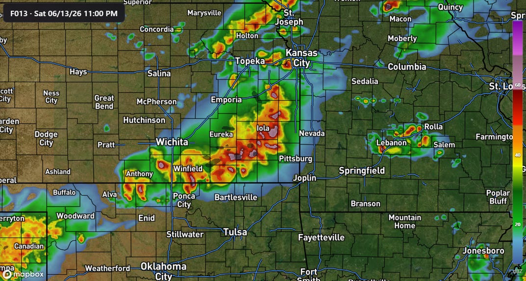
Initial scattered severe thunderstorms late this afternoon and evening should eventually form into an intense squall line that will have a rather high risk of significant damaging straight line winds as it moves southeast overnight across eastern Kansas, southwest Missouri and potentially northeast Oklahoma and northwest Arkansas. Tornadoes will also be possible within the line as low level wind shear will increase overnight.
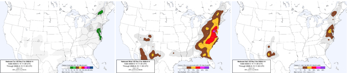
On Sunday, the risk is expected to focus on the East Coast as a cold front will move into a hot and humid airmass, triggering scattered severe thunderstorms capable of producing damaging downburst winds along with possibly a few tornadoes and incidences of large hail.
Programming Note: Given the increase in active weather, I have started utilizing the Substack Chat feature again to share real-time updates. I will be utilizing chat and possibly occasional live videos over the next several days — as a reminder, these are benefits that paid subscribers receive for their support of Balanced Weather. Any videos I do will also be recorded and shared to all subscribers. I also provide updates on my BlueSky and Facebook feeds, and via occasional Substack Notes. To see an example of my Substack chat updates from the Thursday night severe weather in the Midwest, click here.

Leave a comment