
Also: looking at changes to how central Pacific tropical forecasts are being issued by the NWS.
Aug 16, 2026
Lots of impacts to discuss with Tropical Storm Lala in Hawai’i today, but before I get into that I want to discuss a change that has apparently occurred in NWS tropical operations. When I started in meteorology in the 1980s, the NWS had three operational hurricane centers: the main National Hurricane Center in Miami, the Central Pacific Hurricane Center in Honolulu, and Eastern Pacific Hurricane Center in San Francisco.
At that time, the NWS had several sort of “super” forecast offices that had responsibility for various international and oceanic forecasting roles. These offices had some supplemental staff and forecasters had higher grades (i.e., were paid more) due to extra responsibilities. San Francisco and Honolulu were two of these offices (along with New Orleans, Chicago, New York and others), and the tropical forecasting responsibilities of the eastern and central Pacific were part of their operational portfolio.
In 1988, the NWS consolidated responsibility for tropical forecasts for the Atlantic and the eastern Pacific (east of 140 degrees West longitude) at the National Hurricane Center in Miami. However, the Central Pacific Hurricane Center (CPHC) remained a part of the Honolulu forecast office and retained tropical forecast responsibility for the central Pacific basin from 140W to the International Date Line. Back in 2019, the NWS consolidated the tropical websites into a single hurricanes.gov site — but CPHC at NWS Honolulu continued to have the responsibility for issuing outlooks and forecasts for tropical cyclones in the region.
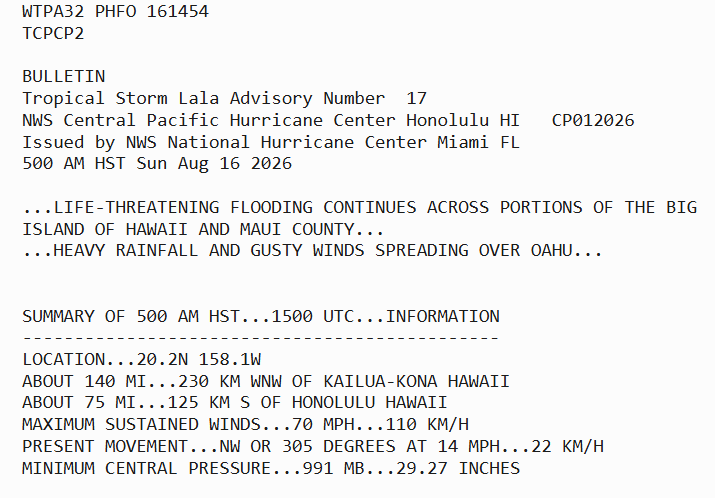
Having said that, I had noted that in the last couple of years that many tropical products issued for the central Pacific had the header as this morning’s advisory for Tropical Storm Lala does — stating that it “originated” at CPHC but was issued by NHC in Miami. This sort of product header typically indicates that an office is issuing products for another office in a service backup mode, i.e., that CPHC is unable to issue its normal products for some reason and NHC is picking up the responsibility.
I assumed that this was happening due to some of the chronic staffing issues the NWS has faced in the last couple of years. What I did not realize is that NHC has been issuing all of CPHC’s products. I have recently heard from a couple of my colleagues in the NWS that this is a permanent change and that CPHC essentially no longer exists. NHC now has the responsibility for all of the Pacific east of the International Date Line. There are still a few meteorologists who work out of the NWS Honolulu office as tropical forecasters, but they are officially part of the NHC organization.
I am sure there are a number of reasons this change was made, and without knowing more about exactly how and why the change was implemented it is hard for me to gauge the potential pros and cons. As I talked in my post about NWS challenges on Friday, I am taken aback by the lack of transparency about this and other agency organizational changes, and do not understand why the products are still being issued as if CPHC is still an extant organization. Perhaps technically on paper it still is in some way — but it certainly sounds as if in practice, CPHC is no more. If I learn more, I obviously will share as I can.
Tropical Storm Lala is continuing to move across the central Pacific today, with the center of circulation clearly visible about 75 miles south-southwest of Honolulu in this MRMS reflectivity mosaic loop.
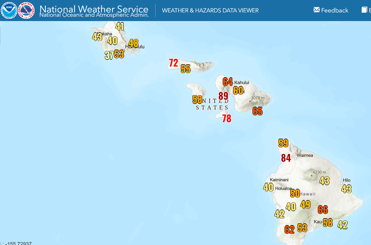
Lala obtained category 1 hurricane status on Saturday as it skirted the southern tip of the Big Island of Hawai’i — while it did not make official landfall (the center of the eye crossing land), it did become the first hurricane to have part of its eye pass over the island. Lala is now a strong tropical storm with 70 mph winds. It has produced strong winds across the islands as shown on the map of maximum wind gusts above. Nearly 200,000 customers in the state of Hawai’i are without power this morning per PowerOutage.us, which is about 40% of the customers in the state.
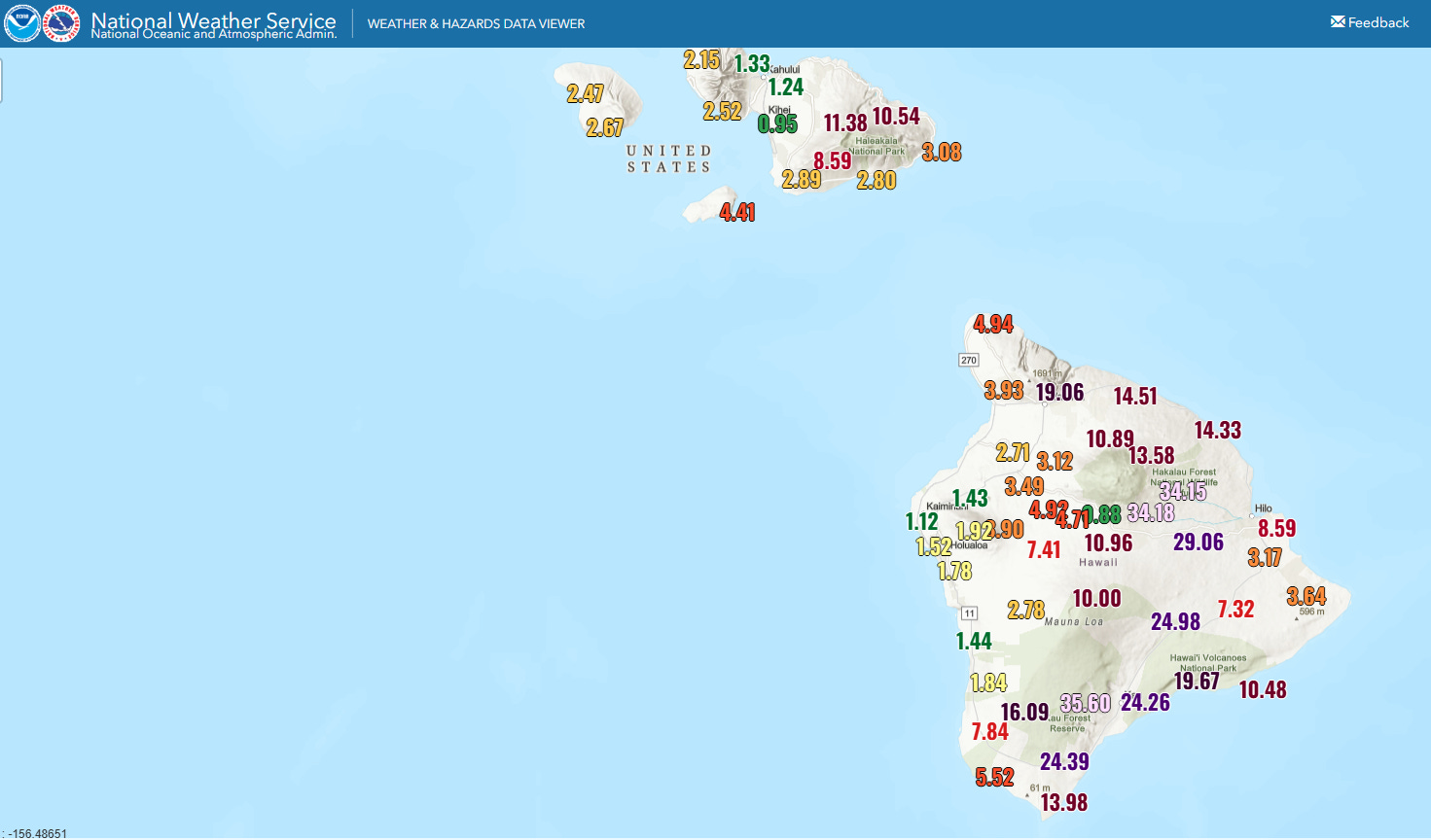
Rainfall from Lala has been prodigious on windward sides of the islands, particularly the Big Island where totals are approaching 3 feet in some locations. Flash flooding has been common and number of streams are in flood.
![[Key Messages]](https://substackcdn.com/image/fetch/$s_!I4k2!,f_auto,q_auto:good,fl_progressive:steep/https%3A%2F%2Fsubstack-post-media.s3.amazonaws.com%2Fpublic%2Fimages%2F72a75136-6db7-4faf-a13c-c8a395c0c9cb_897x736.png "[Key Messages]")
Lala will continue to impact the islands today with heavy rainfall and flooding, strong winds and heavy surf. However, the impacts should start to diminish from east to west by Monday as the storm continues to move to the west. Lala is expected to begin to intensify again early this week as it moves toward the International Date Line.
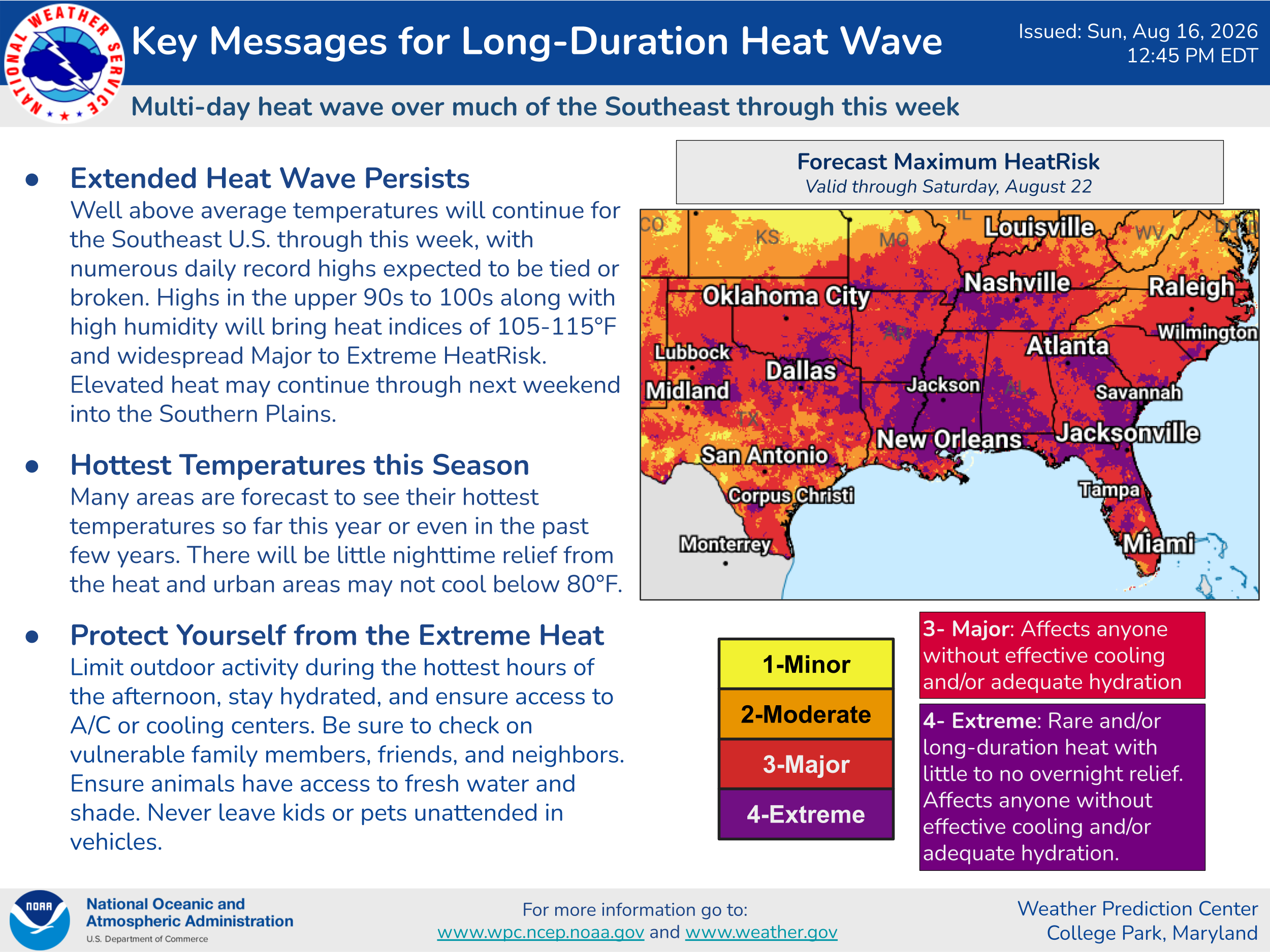
The other big national weather stories revolve around the continuing intense heat wave across the southern and parts of the central United States — and the ongoing barrage of strong to severe thunderstorms from the Midwest into the Mid-Atlantic on the north side of the upper level high pressure producing the heat.
Indiana has been ground zero for impacts from these storms. More than 100,000 customers are still without power in northwest Indiana from last week’s derecho, and central and eastern parts of the state are reeling from extensive flooding, including record flooding on the White River in central Indiana. State officials reported that 6 people have died in weather related incidents over the past week and that thousands of buildings and homes have been damaged across the state by wind and flooding.
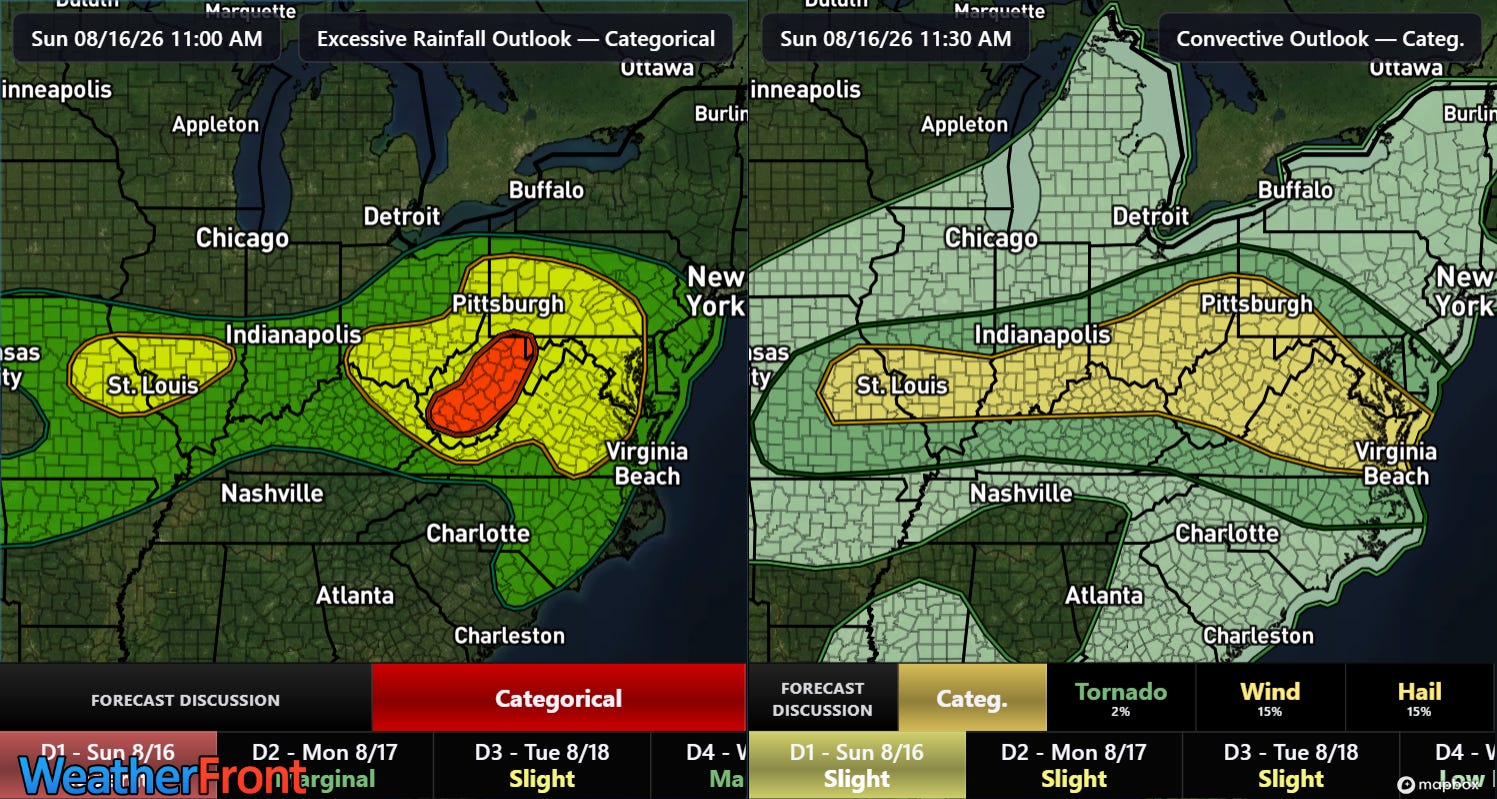
Active thunderstorm activity is expected again today. A slight (level 2 of 5) risk of severe weather is outlooked from the Mid-Mississippi Valley to the Mid-Atlantic coast — while flash flooding will also be a threat with the greatest focus across West Virginia where a moderate (level 3 of 4) risk is in place.
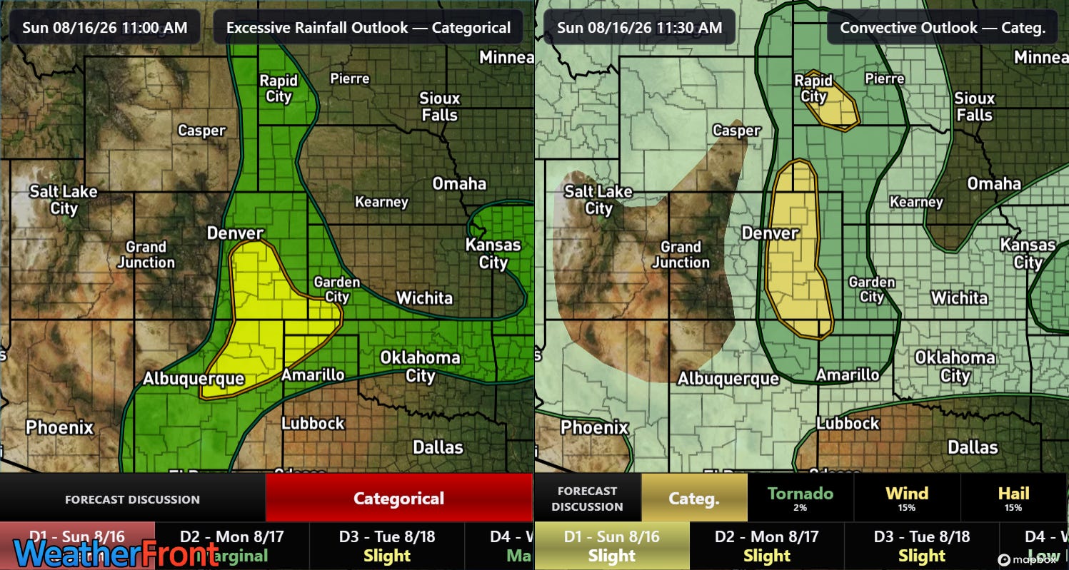
Flash flooding and severe weather will also possible along the eastern side of the Rockies today as monsoonal moisture continues to push north on the west side of the upper level high pressure center.
I did a live tracking of Lala’s impacts in Substack chat Saturday afternoon and evening, and given the active weather expected today, I will be doing another Substack chat. As a reminder, participating in live events is a benefit that paid subscribers receive for their support of Balanced Weather. Any videos I do will be posted for all subscribers as soon as I can get them processed.


Leave a Reply