
Heat will expand to encompass much of the eastern two-thirds of the nation this week
Aug 30, 2026
Yesterday’s newsletter about federal disaster declaration delays and decisions yielded quite a bit of good discussion on social media and the post itself. Before I get into today’s weather, I want to highlight some important points that arose in that conversation that I think are of broader interest.
One thing that I did not consider but that was raised by a couple of people to me is that this most recent flooding in Texas has not received the media attention that last year’s did due to the (thankfully) much lower loss of life. The lack of media attention has reportedly led to less in the way of outside donations and support from what was seen last year. The damage was very extensive, though — this story from News 4 San Antonio discusses how hundreds of homes in Uvalde were damaged by flood waters, and that many were not in “100-year floodplains” and hence many people apparently did not have flood insurance. Hopefully, the federal assistance authorization will be approved soon — if you are interested, you can follow the status of this disaster request on FEMA’s website here.
This Washington Post article from last week discussed a recently released report from the DHS Office of Inspector General about FEMA disaster response crews avoiding homes that had campaign signs for President Trump in the response to Hurricane Milton in Florida in 2024. This occurred during the Biden Administration and yielded charges of politicized disaster response from Florida state officials — although FEMA at the time said that it fired the crew responsible, and the crew itself claimed that unclear safety protocols were their reason for skipping the homes in question. The DHS OIG report on the incident noted that it “eroded public trust in FEMA’s ability to treat everyone impartially, offer unbiased and consistent assistance, and ensure equal access to resources and tools,” and made recommendations for the agency to improve weak training and operational protocols it said were to blame.
While I am not so naive as to believe that politics do not play some role in disaster preparedness and response at all levels of government — after all, human beings are involved and we have our own intrinsic biases and perspectives — I do believe everything should be done to minimize that and “treat everyone impartially” as noted in this OIG report. Hopefully, the more attention that is brought to these issues will help build that a culture that minimizes the political aspect of disaster response.
Finally, I want to highlight this subscriber comment on the post that raised the importance of moving the conversation around FEMA and disaster response past a focus on response and recovery and increasing the focus on risk-reduction and mitigation. This is a hugely important point and one that I have raised in past newsletters — I encourage you to read Ken’s comments.
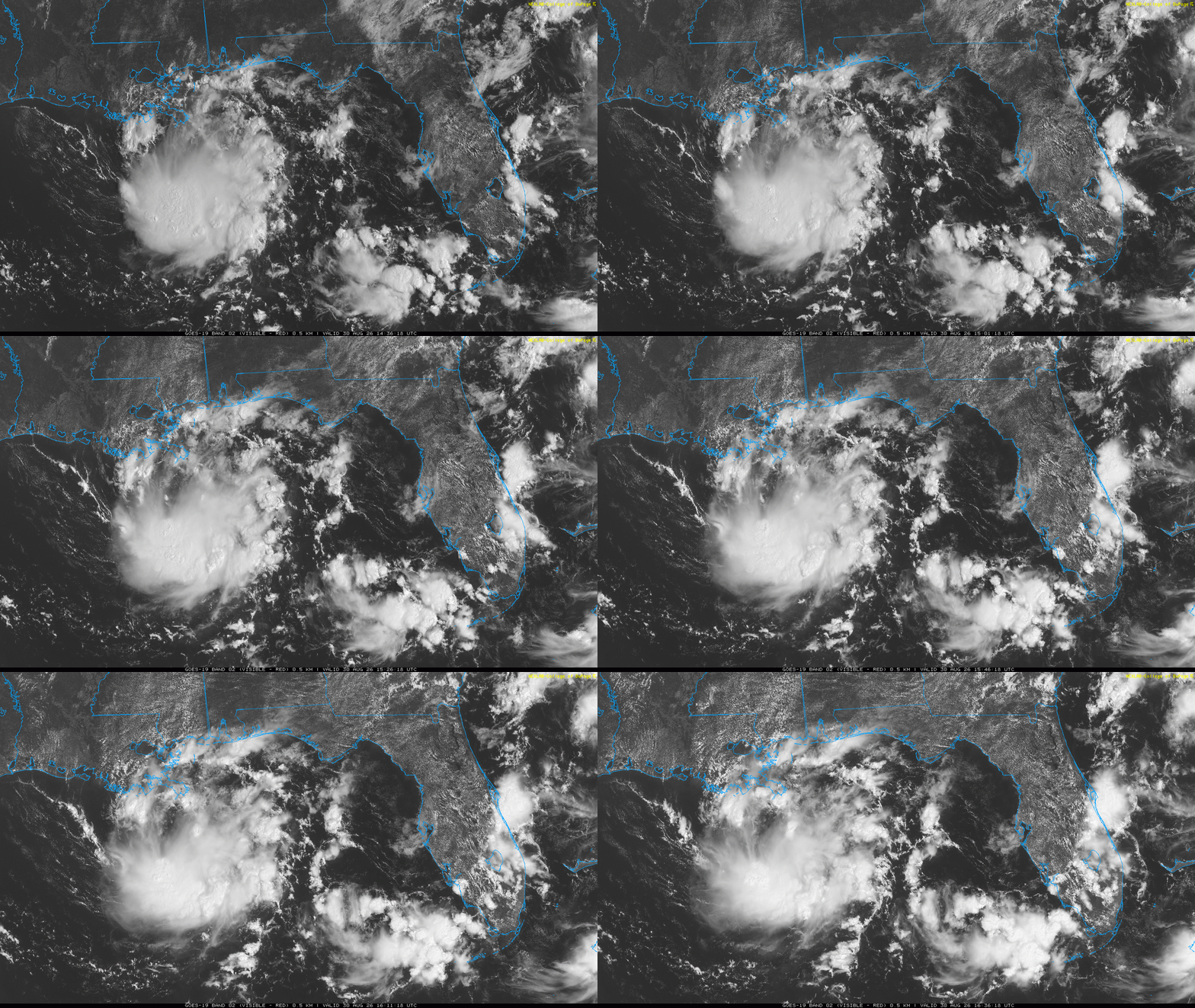
Starting off today’s weather in the tropics again with a look at the disturbance in the northern Gulf I discussed yesterday, which has now been designated Invest 97L by the National Hurricane Season. The system has continued to gradually improve in organization since yesterday — if you look closely you can see a twist in the to the south-southeast of the mouth of the Mississippi River which shows where a circulation is trying to develop. NHC has increased the odds of this system developing to 30%, and overall conditions do not look too hostile for development. Shear is forecast to be light and the system will be moving over warm water.
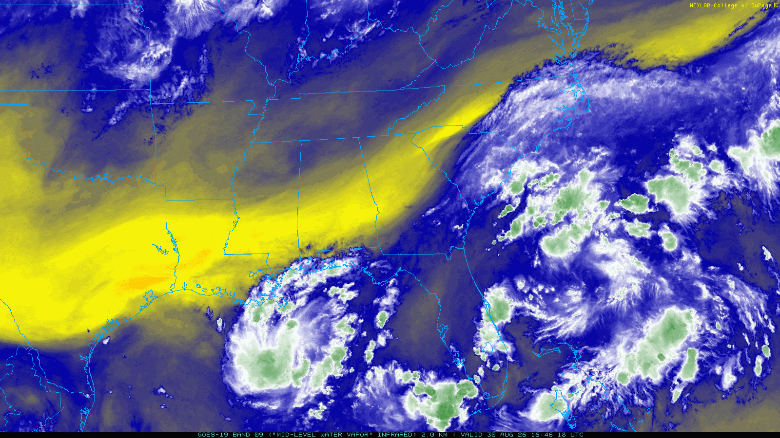
Likely the major deterrent for development is the extremely dry air we can see in water vapor imagery (the yellow area) to the north and northwest of the system. The stronger the system becomes, more of that dry air will be pulled into it which would be a brake on intensification. The models have become a bit more enthused about this system developing into a defined tropical cyclone, but still the signal is rather muted and anything more than a tropical storm seems unlikely.
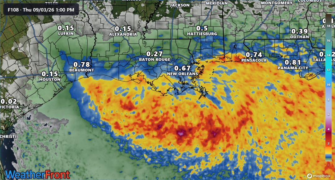
The system should be moving inland somewhere along the southeast Texas coast by late Tuesday or early Wednesday. With the dry air nearby, the models are not even showing much in the way of heavy rainfall potential with it, mainly just some 1-2” amounts along the coast. If the system were to get stronger than forecast this risk could increase though. While expectations are currently not for a particularly robust, organized cyclone, systems like this close to the Gulf Coast have pulled surprises before — so we will keep a close eye on it over the next couple of days.
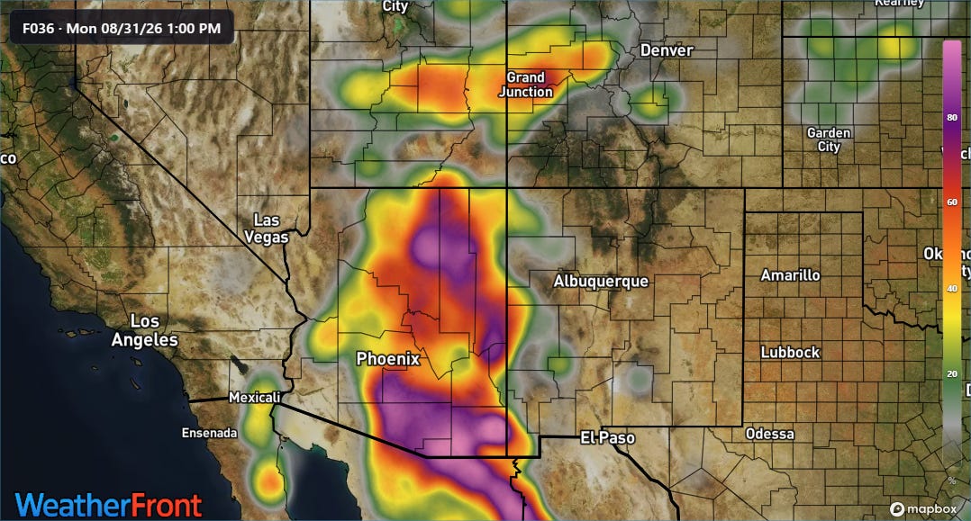
Of more immediate concern for heavy rain and flash flooding is the Southwest, where increasing monsoonal moisture today will bring a risk for thunderstorms with heavy rainfall and flash flooding. The most recent REFS high resolution ensemble model forecast shows high probabilities for areas of 1” or more of rainfall across much of Arizona over the next 24 hours, with somewhat lower probabilities across parts of Utah and western Colorado.
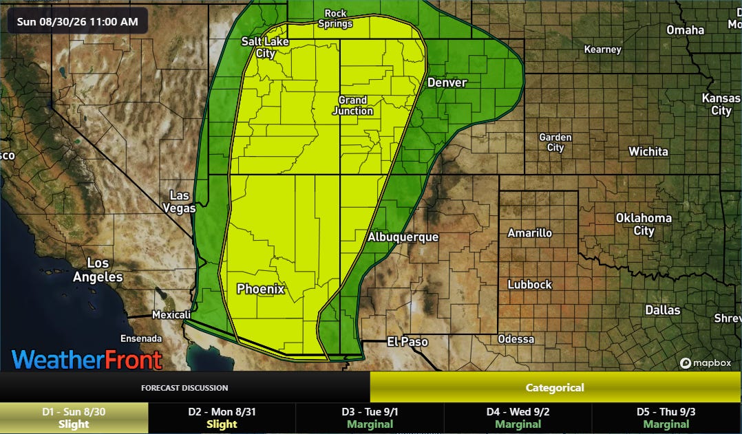
These rainfall amounts would be occurring in a relatively short period of time and could produce some incidences of flash flooding. The NWS Weather Prediction Center has a slight (level 2 of 4) risk of flash flooding for much of this area through tonight.
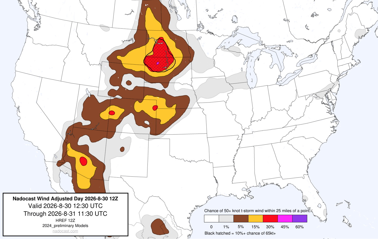
Severe weather will also be a concern with thunderstorms in this region, with damaging winds the primary risk but a few incidences of large hail also possible. That risk will extend up into the Dakotas where an upper level weather disturbance will provide forcing for more organized clusters of severe storms that could produce significant damaging winds. The Storm Prediction Center has a slight (level 2 of 5) risk of severe storms in this region.
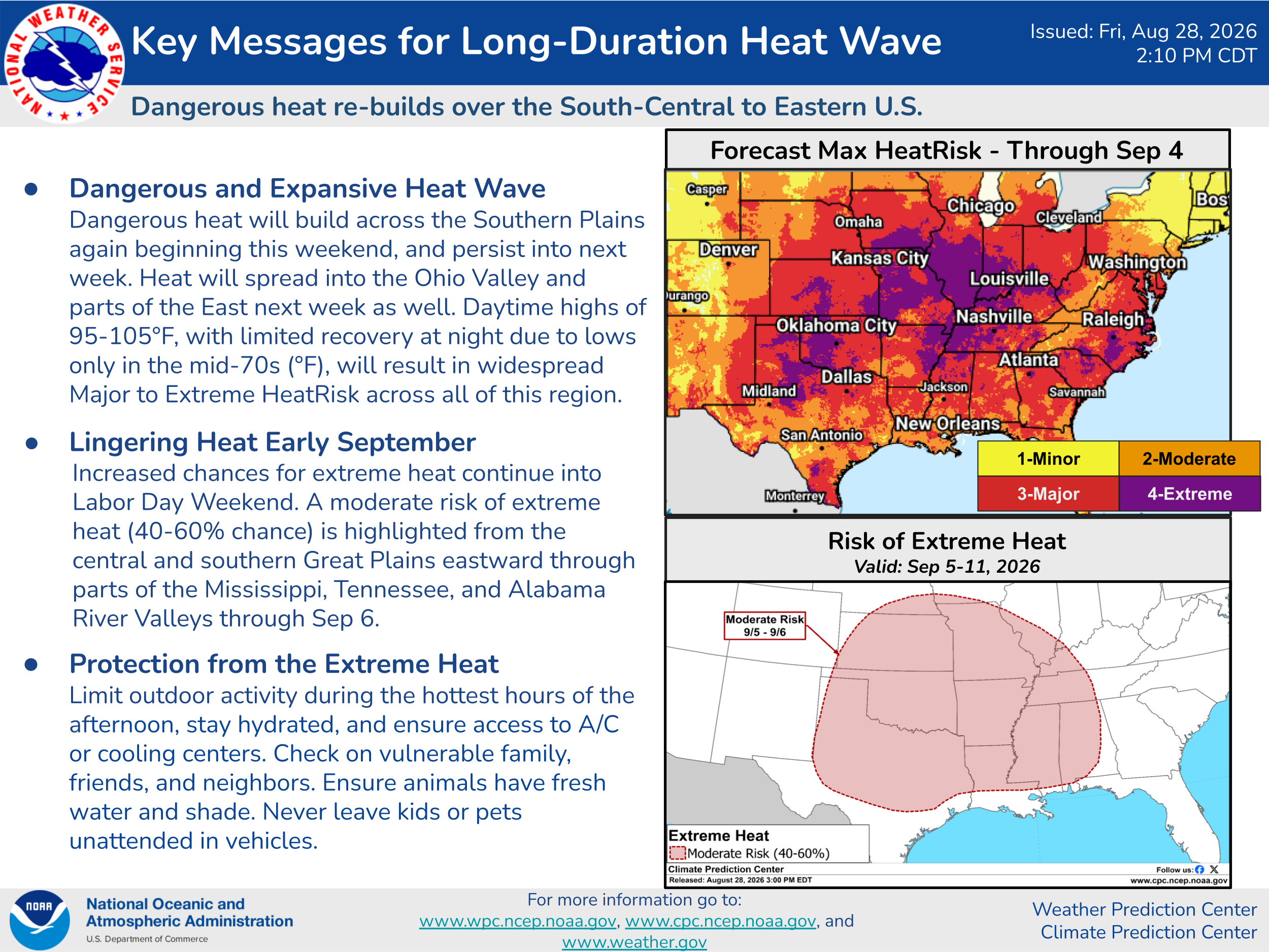
The potential for record heat today will primarily be focused in the Southern Plains, but as the week goes on heat and humidity will expand across much of the country east of the Rockies. Record high temperatures will become more numerous, and dozens of record high minimum temperatures are expected by the middle of the week due to the combination of heat and high levels of humidity. This will result in widespread major to extreme heat risk for much of the upcoming week.


Leave a Reply