
Eastern Pacific very active as well with potential impacts for Hawaii and western US
Aug 31, 2026
It is a Monday and the tropics are very active so today’s post will be a tropical update. There are certainly other big weather stories ongoing, including the aftermath of Saturday’s major flash flood in Grand Canyon which left at least 1 dead and 15 missing and serious wildfires in the California’s Big Sur region. I briefly talked about these in last night’s post, and hope to have more details on this as well as the growing heatwave across the eastern two-thirds of the US in later posts or videos today.
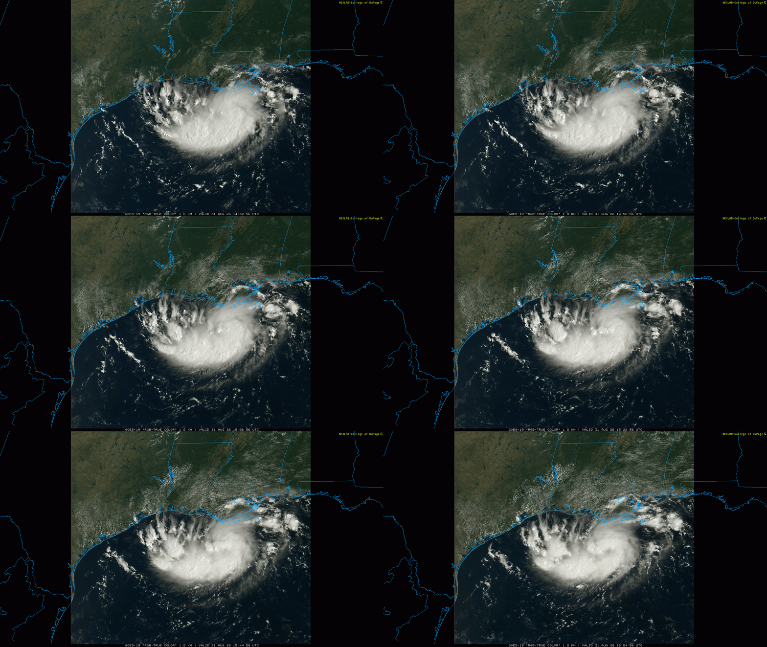
The tropical disturbance over the northern Gulf of Mexico continues to gradually get better organized today. US Air Force reconnaissance aircraft are in the system, and the most recent pass through the system shows an increasingly well organized low level circulation. Along with the relatively organized pattern of showers and thunderstorms, the system is very close to being (or already is) a tropical depression and likely will be designated as one soon.
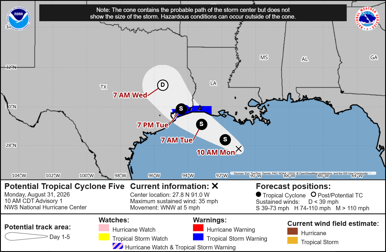
NHC began issuing advisories and forecasts on the system which is now known as Potential Tropical Cyclone (PTC) 5 late this morning. There is still some uncertainty in track, especially given that the system is still getting organized and there could be shifts in the exact location of where the low level center of circulation consolidates. In general, though, it should turn more northwest toward the southeast Texas or southwest Louisiana coastlines, making landfall in about 24 to 36 hours.
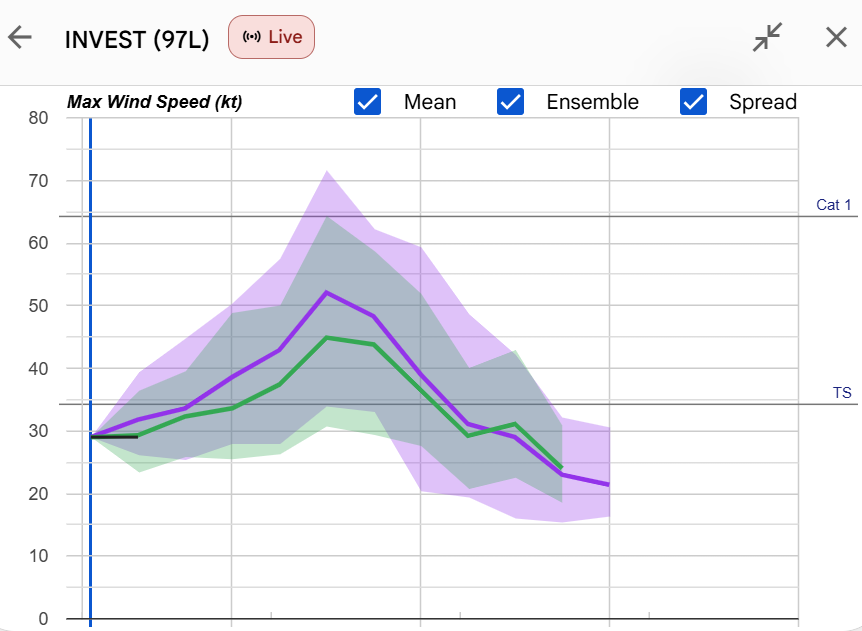
As I have been discussing over the weekend, conditions ahead of PTC5 are relatively favorable for development, with light wind shear and warm waters. Looming drier air to the north is the main deterrent for a stronger system to develop — along with the fact it will only be over water for another 24 to 36 hours. As the system has become better organized, the intensity forecasts for the system have come up. The mean ensemble forecast from the Google DeepMind AI system which had the best Atlantic hurricane guidance in 2025 shows it becoming a mid-range tropical storm before landfall.
PTC5 is expected to be a relatively small system, and one thing we need to keep in mind is that small systems like this are prone to rapid fluctuations in intensity. I liken it in some ways to trying to forecast the evolution of a persistent cluster of severe storms over land. Even our best high resolution models can struggle with those forecasts, and given the way past similar systems have strengthened just before landfall (e.g., Humberto 2007), we will need to keep a close eye on observational and model trends up to landfall.
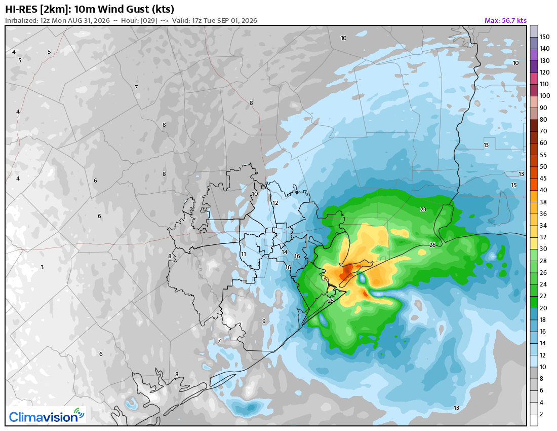
As an example, the most recent run of the Climavision high resolution model shows 60 to 70 mph wind gusts as the system makes landfall in Galveston Bay Tuesday afternoon. This is a single deterministic model that shows just one possible outcome, but it gives an idea of a plausible possibility. A handful of the 50 members in the Google DeepMind AI forecast available online also make the system a hurricane before landfall. Again, these are likely the high-end extreme solutions — but given occasional surprises in the past, I will be watching things closely in the next day.
![[Image of U.S. rainfall potential]](https://substackcdn.com/image/fetch/$s_!0ueI!,f_auto,q_auto:good,fl_progressive:steep/https%3A%2F%2Fsubstack-post-media.s3.amazonaws.com%2Fpublic%2Fimages%2Fd25a192e-2947-471f-aabf-6536fb1a0ab2_892x716.gif "[Image of U.S. rainfall potential]")
Rainfall potential has also continued to increase as the system has become better organized. The Weather Prediction Center is now forecasting a swath of 4-8” of rain across parts of southeast Texas with PTC5. Given the small size of the storm this will likely be a rather focused rainfall event, and shifts in the track will cause shifts in the heaviest rainfall.
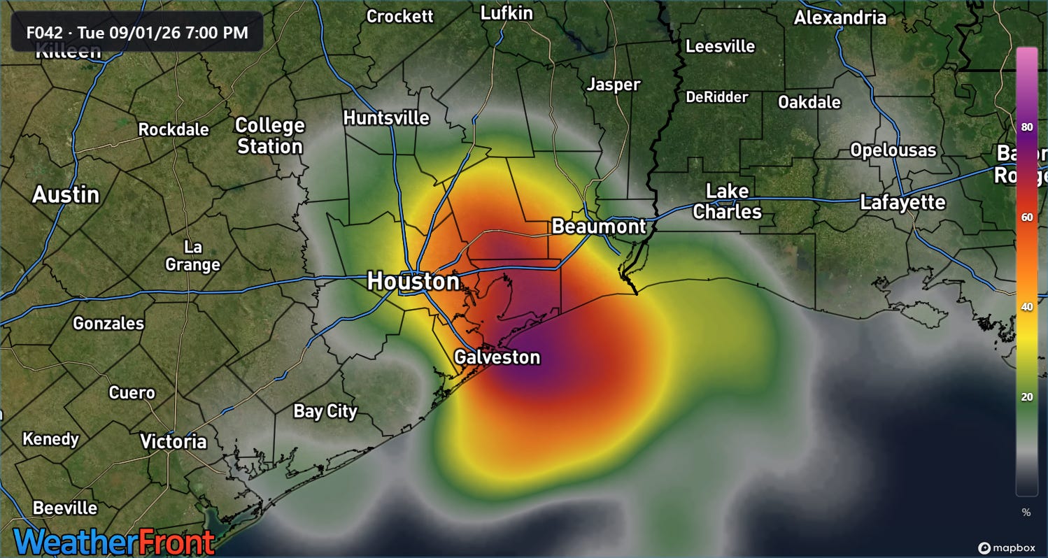
The most recent run of the high resolution rapid refresh ensemble model shows high probabilities for areas of 5+” of rain in southeast Texas Tuesday, and with anticipated high rainfall rates, flash flooding is a concern particularly in urban areas.
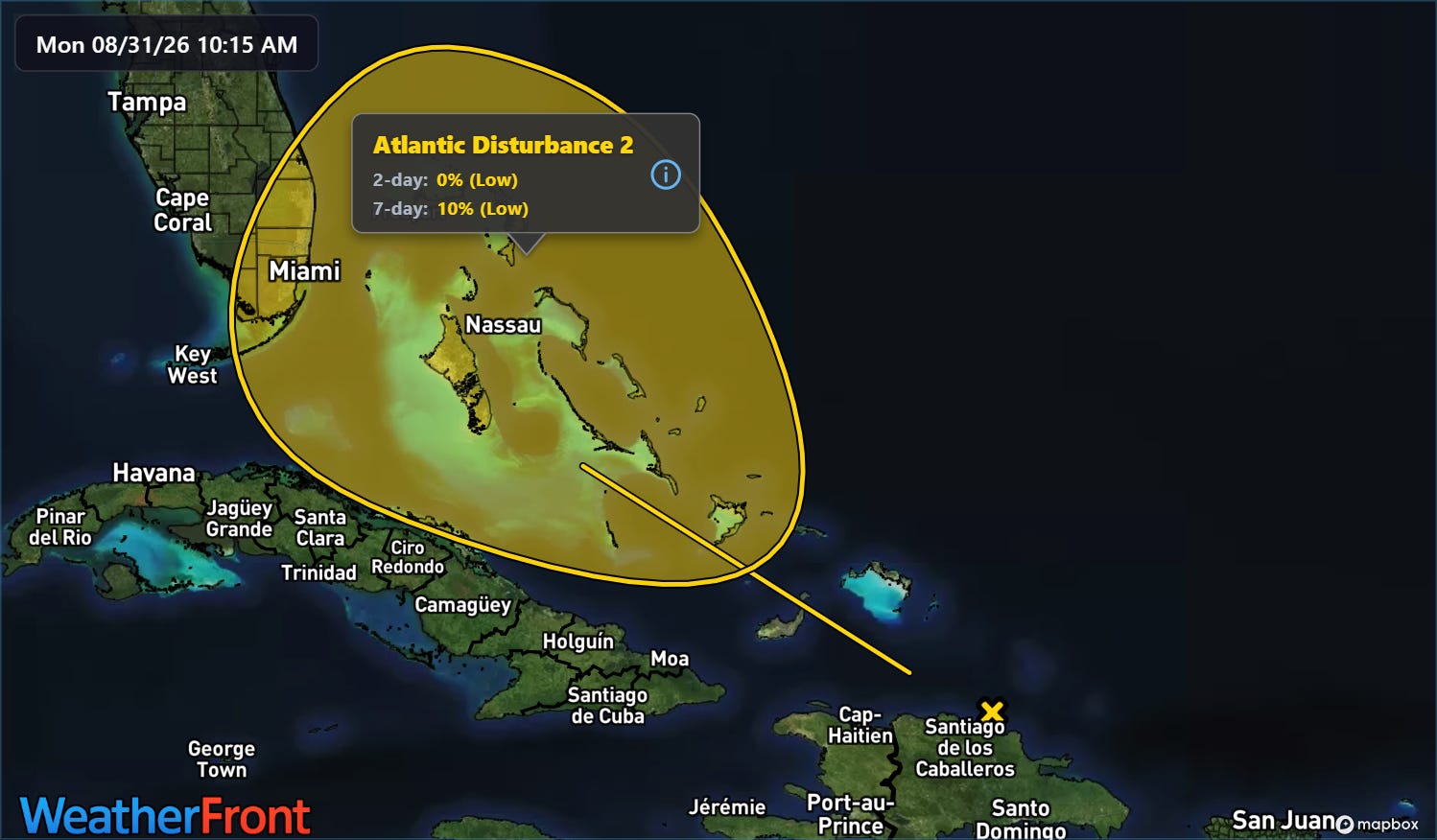
Elsewhere in the Atlantic, the remnants of Dolly have become increasingly disorganized over the last 24 hours and the models have continued to become less enthused on the idea of anything redeveloping out of it. NHC is continuing to monitor it, but the already low probabilities of regeneration have now come down to 10%.
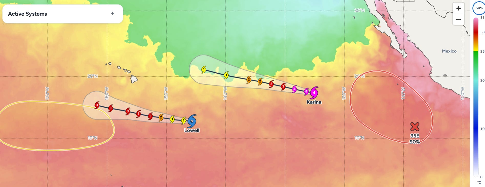
Meanwhile, the eastern Pacific is also extremely active, with Karina having intensified to a category 4 hurricane in the last 24 hours, and Lowell on the verge of becoming a hurricane. Another system (Invest 95E) to the southwest of the Mexican coast should become a tropical storm in the next 24 hours (Marie would be the next name), and NHC (CPHC? who knows? Not gonna derail the weather discussion for this again, but will likely revisit soon) is monitoring another system with low probability of development well south of Hawai’i.
Lowell and the likely future Marie are the two main features of interest for the US as Karina should remain north and northeast of Hawai’i. As can be seen in the map above, Lowell is forecast to intensify into a major hurricane over the next several days as it continues west-northwest to the south of Hawai’i.
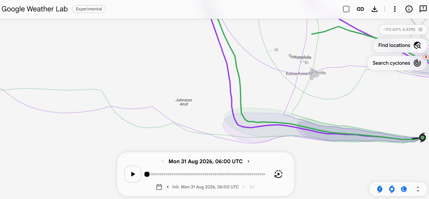
After this time though, Lowell is expected to make a turn to the north. However, the longitude of where that turn will occur remains quite uncertain — it is still many days away and, as I discussed in Saturday’s newsletter, the steering pattern is expected to be rather complex. Some of the forecasts from the individual members of the Google DeepMind AI show this turn happening far enough east to pose a threat to the western part of the main Hawaiian Islands, while others show it happening well west out near Johnston Atoll. The mean of the forecasts have shifted a bit west over the last 48 hours which is a positive sign for Hawai’i — but given how far out in time we are talking, we still need to keep an eye on Lowell for potential impacts, and of course it is also of even more concern for any interests in the Northwestern Hawaiian Islands.
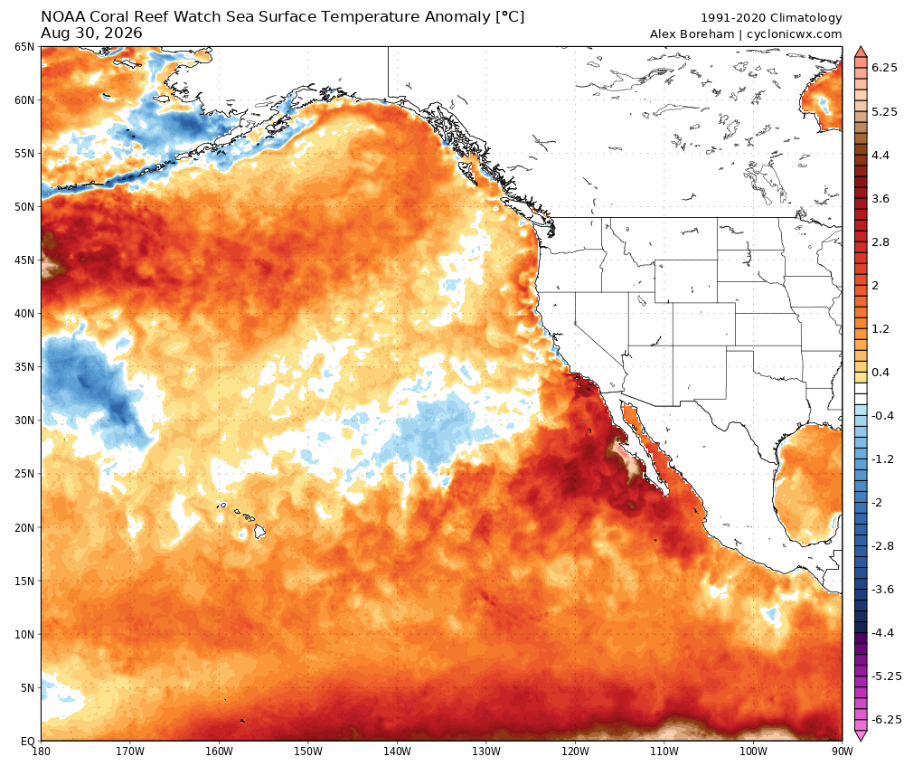
For the system that is about to become Marie, there has apparently been a lot of social media and some broadcast hype over some runs of the US Global Forecast System model showing this system heading toward California as a hurricane. Given the unusually warm water off the California coast which could help sustain a tropical system more than normal along with the very active El Nino tropical pattern in the eastern Pacific, there is certainly reason to be a bit extra concerned about the potential for a tropical system at some point this season in this region.
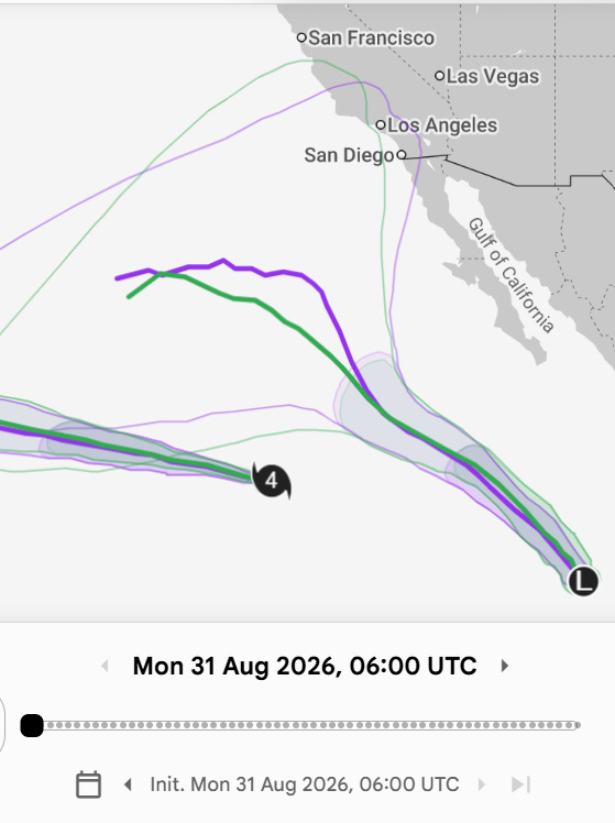
However, for this specific system, the GFS forecast in question is a rather extreme outlier in the overall model ensemble. The Google DeepMind AI ensemble shows a relatively typical track to the northwest over the eastern Pacific, followed by a turn to the west as the system weakens. A few members of the GDM ensemble do take a track more toward California, but they are the small minority.
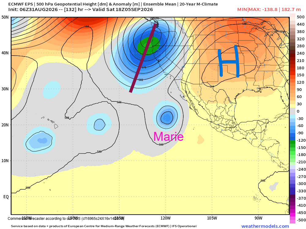
Having said that, the overall weather pattern forecast for next week is a reason to keep a bit of an extra eye out in California. A deep trough of low pressure aloft is forecast to evolve along the West Coast, with a downstream area of strong high pressure developing (again) over the central United States by this weekend. Depending on the exact timing and strength of these features and the ultimate track of future Marie, there is at least some chance that the tropical system could get caught up in a steering channel between these two large scale weather systems and move more toward the Southwest US.
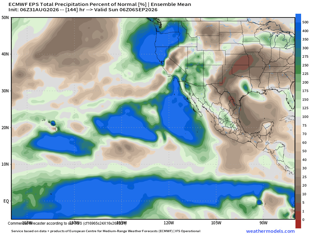
Given that we do not even have the tropical system completely formed yet, this will also just be something to keep an eye on this week. At a minimum, some enhanced Pacific moisture should move toward the Southwest by this weekend.


Leave a Reply