
Lowell and Molly worth watching in the Pacific
Sep 01, 2026
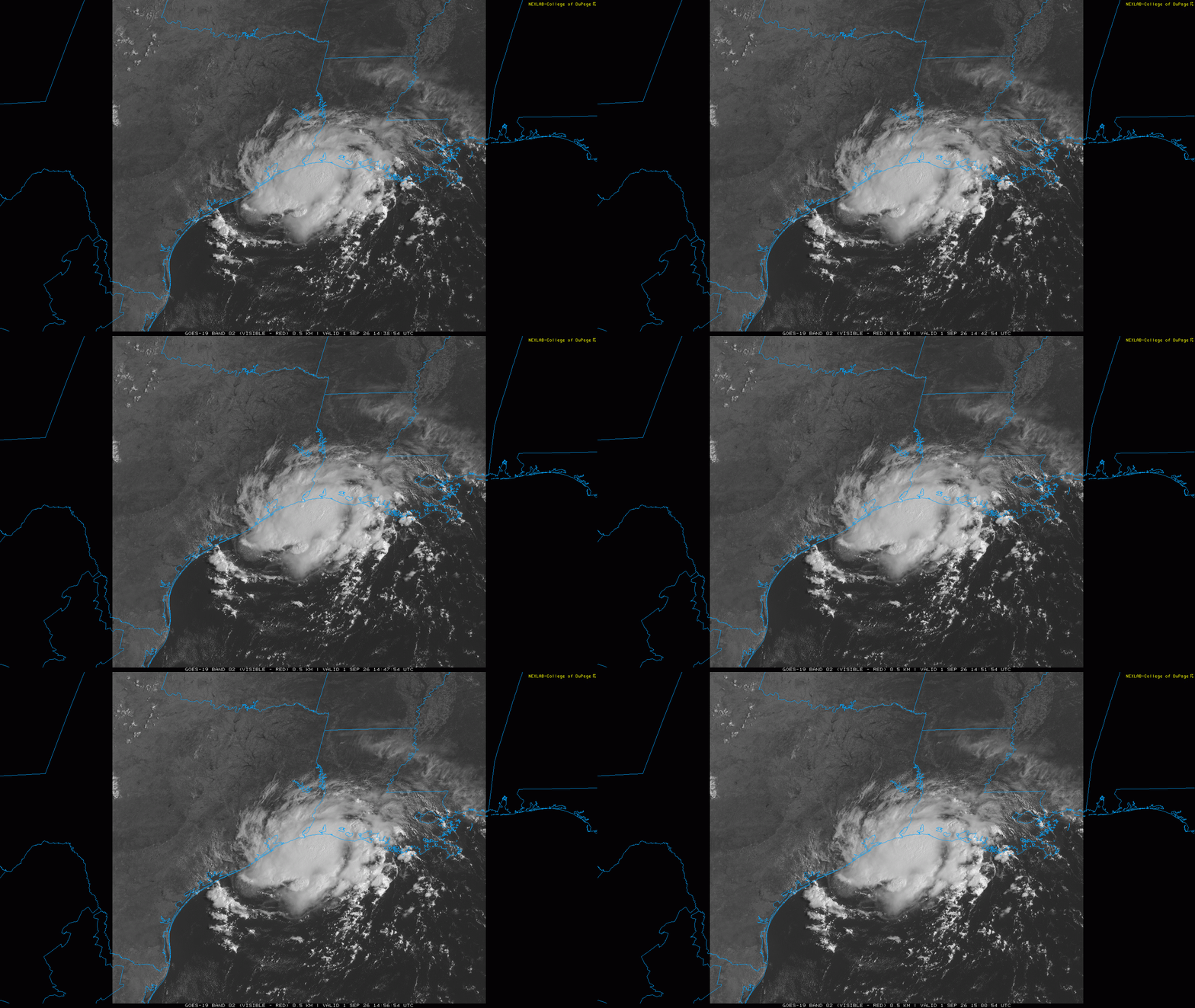
GOES visible satellite imagery this morning reveals for the first time this Atlantic hurricane season something that actually looks like a tropical cyclone — albeit a small one — as Tropical Storm Edouard continues to strengthen near the Gulf Coast. Increasing strong thunderstorm activity continues to wrap around an intensifying low level circulation which is centered about 50 miles southeast of Port Arthur.
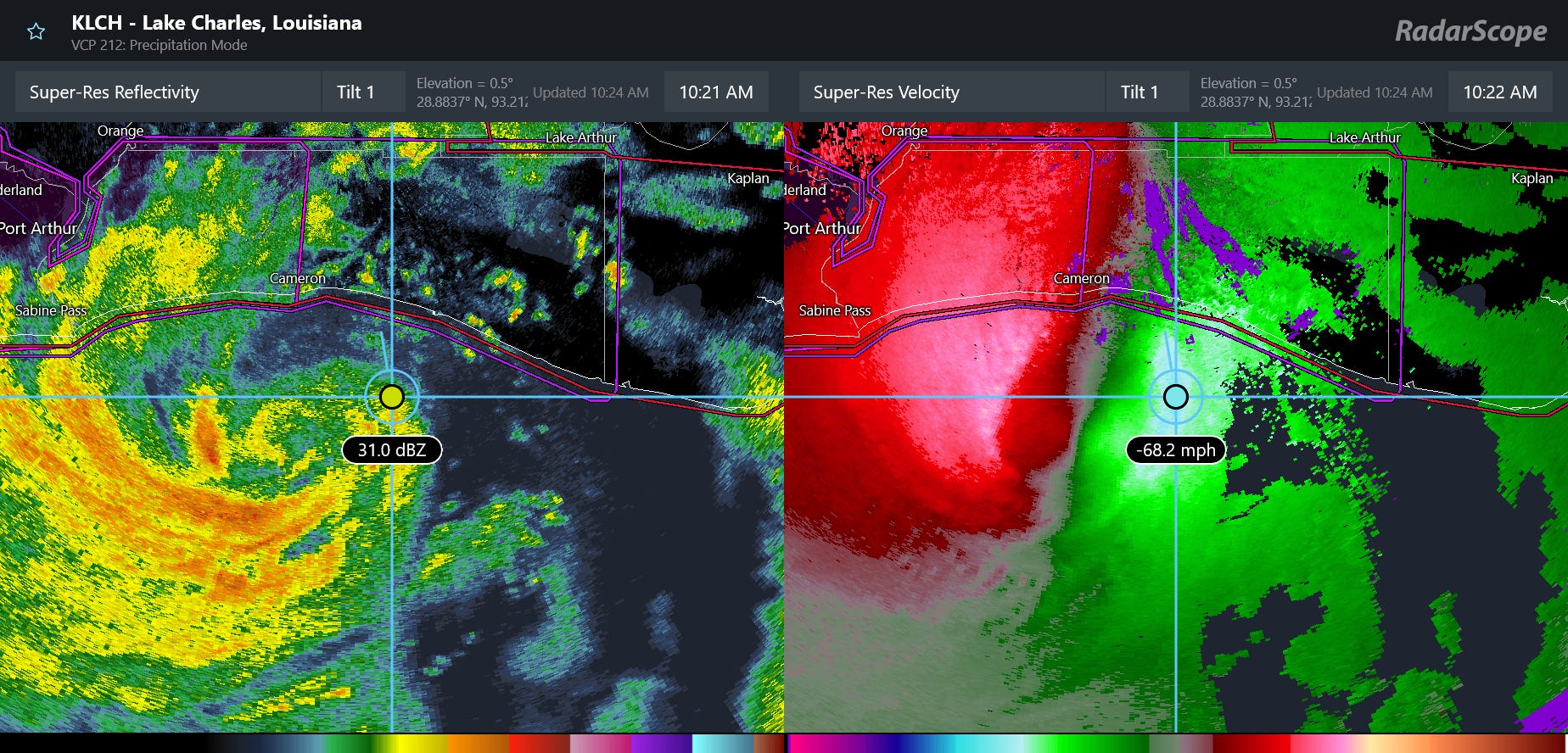
Radar shows the inner structure of Edouard bteter, and as the center drifts west-northwest toward the coast it has been showing pockets of 60 to 70 mph winds on the northeast side of the developing eyewall. These winds are aloft not at the surface, but it certainly that maximum sustained winds at the surface are at least the 50 mph estimated by NHC in the 10 am CT advisory, and we will be monitoring radar data intently for signs of further intensification.
Luckily, Edouard will be making landfall a bit quicker than it appeared yesterday, and will likely come onshore somewhere near the mouth of the Sabine River in the next few hours. Less time over water and the dry air we talked about the last couple of days getting entrained into the system has kept us from dealing with a more intense situation — but Edouard is expected to take advantage of the minimal wind shear and warm water and continue to strengthen up until that landfall. The core of Edouard is small so strong winds should be limited to near the center — but as NHC notes hurricane forecast winds at least in gusts will be possible and this could certainly cause some issues with power outages and other wind impacts near the core of the storm. A few tornadoes will also be possible near and to the east of where Edouard’s center moves.
![[Image of cumulative wind history]](https://substackcdn.com/image/fetch/$s_!R4BA!,f_auto,q_auto:good,fl_progressive:steep/https%3A%2F%2Fsubstack-post-media.s3.amazonaws.com%2Fpublic%2Fimages%2F0b4dd653-bcd7-4230-bbe1-fa3cf668a23b_897x736.png "[Image of cumulative wind history]")
The area where Edouard is making landfall is particularly prone to storm surge, so event though it is a relatively small tropical cyclone, maximum storm surge values of 3 to 5 feet are forecast along coastal southeast Texas and southwest Louisiana where storm surge warnings are in effect.
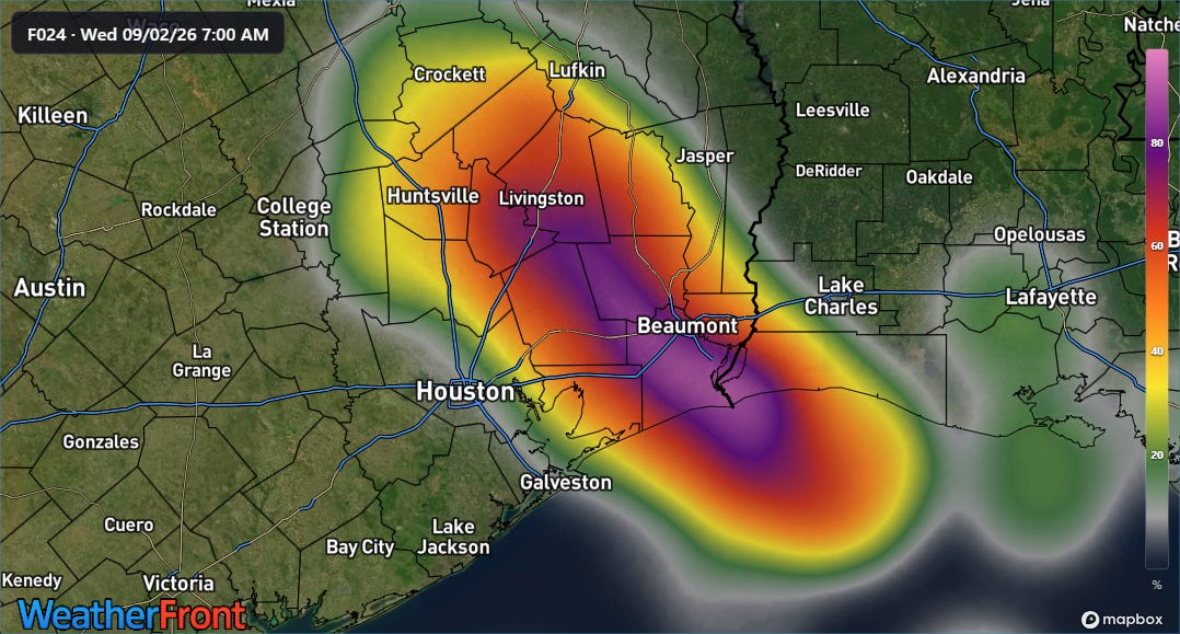
Again, the small, focused nature of Edouard combined with surrounding dry air means that the heavy rainfall threat will be relatively confined to along the immediate path of the storm. The morning high resolution rapid refresh ensemble (REFS) appears to be doing a good job in highlighting the area of maximum risk of 5+” rainfall potential, which given the intense rainfall rates could cause some significant flash flooding particularly in urban areas.
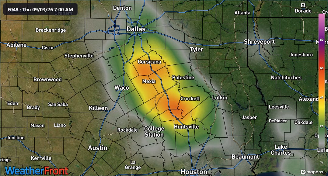
Edouard will be weakening as it moves into the dome of dry, hot high pressure aloft over the south central United States, but some risk of heavy rainfall and flash flooding will persist on Thursday as it moves up the Interstate 45 corridor toward the Dallas-Fort Worth metroplex.
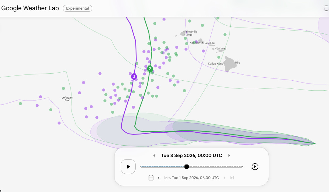
A couple of other tropical notes. Lowell has become a hurricane well to the southeast of the Big Island of Hawai’i and is expected to continue intensifying for the next several days as it moves west. Model forecasts still indicate a significant turn of Lowelly to the north this weekend or early next week — and still have a large spread in where that happens with the easternmost models showing a potential risk to the western part of the main Hawaiian Islands. The mean track of the Google DeepMind (shown above) has shifted a bit to the east over the last 24 hours and this is of course still several days away, so it is worth keeping an eye on.
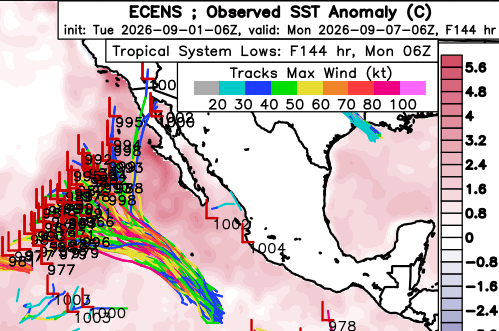
As expected, Tropical Storm Molly has formed well southwest of the coast of Mexico, and is expected to intensify as it moves northwest over the next several days. Most of the reliable model guidance continues to show a weakening Molly eventually turning west or west-northwest over the open eastern Pacific, but a handful of ensemble members do show a turn more toward Baja California or the Southwest US.
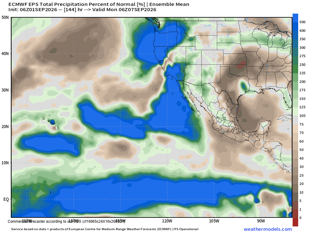
As I discussed in yesterday’s newsletter, the overall large scale weather pattern does favor at least some moisture being drawn up toward the Southwest US next week which could enhance rain and storm chances — and also means it is worth keeping an eye on the track of Molly for any later trends toward the outlier tracks more toward the coast.
I have some tasks to take care of the next several hours, but will try to post occasional updates about Edouard in Substack Chat (benefit for paid subscribers) as I can.


Leave a Reply