
In weather, Edouard is weakening after dumping up to 2 feet of rain; Lowell continues to be a potential risk to Hawaii
Sep 03, 2026
Lots of weather to talk about, but before I get into that, want to talk about some National Weather Service comms and infrastructure stories. First, as noted in this comment by Mike Smith on my reshared Katrina anniversary article, the NWS office in Cheyenne has suffered a major comms failure and services for their area are being provided by other NWS offices.
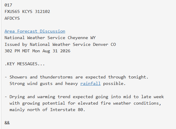
It appears as if the office went down sometime on Monday, and is still without comms as of earlier this morning. From looking at products for the Cheyenne office over the last few days, the NWS offices in Boulder/Denver and Riverton, WY appear to have been providing the bulk of backup services for the area.
This is the latest in an ongoing string of comms and IT failures that have resulted in NWS offices being out of commission for long periods of time, in some cases during severe or impact weather. It also comes on top of a high profile IT and comms glitch that resulted in delays in the timely dissemination of warnings during a severe weather outbreak in early August.
I have noted in past posts how NWS communication failures has been an issue for the agency going back to my own experiences during Katrina, but that aging infrastructure and chronic underaddressing of issues over the years has led to operations being more vulnerable to these sorts of problems now. The NWS is in the process of procuring a new national agency IT and comms infrastructure called HIVE (Hydrometeorological Interactive Virtual Environment) to replace its current AWIPS system that was deployed in the 1990s.
The current deployment schedule targets HIVE to become operational and replace AWIPS by early 2028, which is an incredibly aggressive timeline given that the contracts to develop and deploy the new system were just awarded several months ago. HIVE and its associated database of hydrometeorological data CIRRUS will be cloud-based.
As part of the modernization of its IT and communications structure, the NWS requested feedback this week on the proposed elimination of the Satellite Broadcast Network (SBN)/NOAAPort system, with elimination slated for as soon as August 31, 2027. NOAAPort is the system that “provides a one-way broadcast of NOAA environmental data and information in near-real time to NOAA and external users.” The demise of NOAAPort has resulted in a lot of concern in the weather community as many users rely on NOAAPort for data either directly or through datastreams that rely on NOAAPort.
As of now, the NWS’ public statement encourages users to submit their comments and concerns, but only provides a vague statement about what the future may bring: “We are assembling information about alternative data sources and will provide it as soon as possible.” To be fair to NWS, this a very complicated problem as the communications spectrum continues to become more constrained (which also impacts the gathering and dissemination of hydrometeorological data in many other ways).
At this point, the bottom line seems to be that the development of HIVE/CIRRUS and anticipated modernization of NWS IT/comms is a positive step forward, but there are still a lot of unknowns and questions remaining on the NWS and broader weather community’s data collection and delivery. More to come obviously in the coming months.
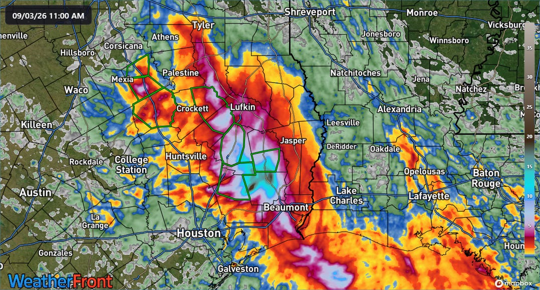
Turning to weather and starting with the remnants of Edouard, the 3-day rainfall product from MRMS shows a focused swath of very heavy rainfall over east Texas.
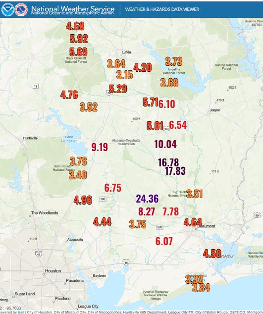
The heaviest amounts occurred between Livingston and Beaumont with 10+” of rain in much of this area. The highest measured amount I have seen so far is 24.36” just northwest of Saratoga, TX. The heavy rain flooded numerous roads and some structures, resulting in evacuations and water rescues.
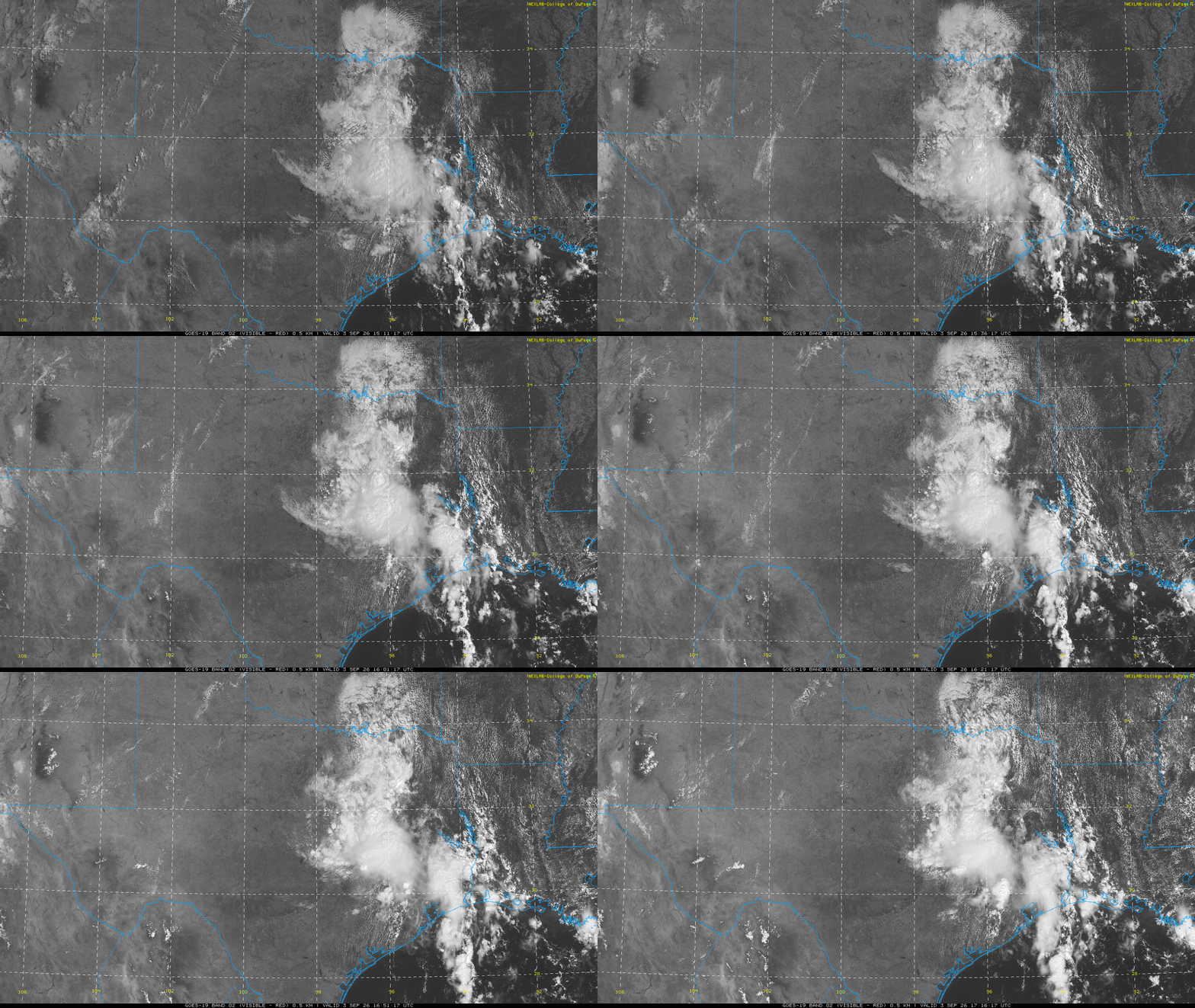
Edouard is definitively weakening now, with visible satellite imagery no longer showing a well defined circulation. While residual high levels of moisture and some enhanced low level inflow will continue to support some clusters of storms with heavy rainfall and some flash flooding potential, the overall risk for organized heavy rainfall will continue to diminish over the next 24 hours.
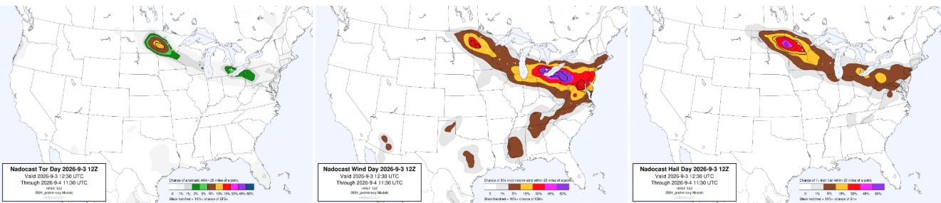
After a busy day of severe weather on Wednesday, the area from the upper Midwest into the Mid-Atlantic looks poised for more action today. One primary area of focus will again be in the Great Lakes, where clusters of severe storms with significant straight line wind damage potential will exist — SPC recently upgraded areas from eastern Lake Erie across western Pennsylvania to an enhanced (level 3 of 5) risk. Another focus will be in northern Minnesota and eastern North Dakota, where supercell storms could produce very large hail, tornadoes and damaging winds.
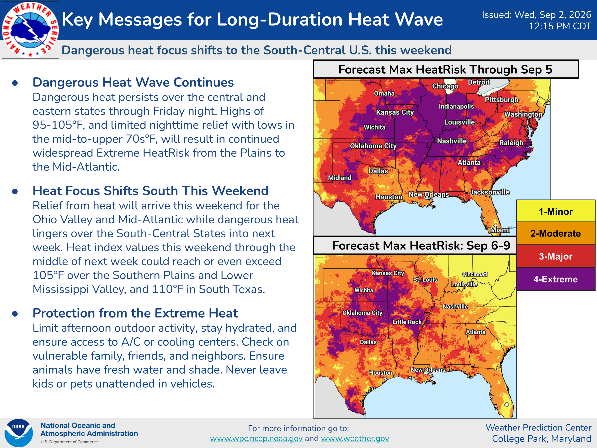
These storms are occurring on the northeast periphery of the large dome of middle and upper level high pressure across the central part of the country which will continue to produce serious and unusual heat risk for September. Excessive heat warnings are now in effect for much of the Lower Missouri, Mid-Mississippi and Lower Ohio Valley regions. Numerous record warm temperatures — both maxima and especially minima — are expected east of the Rockies the next couple of days.
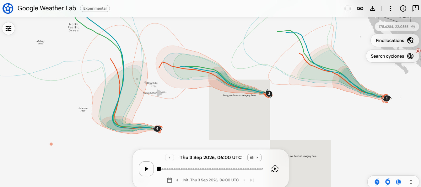
The central and eastern Pacific continues to churn out tropical activity with three hurricanes currently ongoing: Lowell, Karina and Marie. The one of most concern for US interests remains Lowell, which has weakened a bit in the last 18 hours and is now a category 4 hurricane. After some waffling to the west and increasing spread in model guidance from late yesterday, the most recent model runs have shown a tightening in model spread and shift back more toward the right.
The mean model tracks for Lowell continue to show a path to the west of the main Hawaiian Islands, but with the western part of the islands in the envelope with a number of model ensemble members showing a track that could cause impacts, particularly to Kauai. As I discussed in my post yesterday, the steering setup as Lowell turns north is expected to be quite complex, and as a result the models will likely continue to waffle and struggle a bit. NHC continues to urge residents and visitors to Hawaii to monitor forecasts.


Leave a Reply