
Lowell knocks out power to nearly all of Kaua’i, while September heat and humidity will become a coast-to-coast problem for a few days this week.
Sep 08, 2026
As I am sure most people are aware, over the weekend there was a tragic plane crash at Miami International Airport involving a cargo plane overrunning the runway and colliding with ground vehicles, killing 5 people on the groundand injuring several more. This article from the New York Times (gift link) details what is known about the accident, and how the National Transportation Safety Board (NTSB) is investigating it. This part of the article really struck home to me:
The cargo plane crash was the latest aviation tragedy to unsettle Americans in what has been a troubling stretch for the industry. In addition to the fatal UPS crash in November, a passenger jet and a U.S. Army helicopter collided in January 2025 near the Potomac River in Washington, D.C., killing 67 people in the deadliest air crash in the country in 20 years. And in March of this year, a plane crashed into a fire truck at LaGuardia Airport in New York City, killing both pilots. Ms. Homendy (ed note, chair of the NTSB) maintained that the aviation system as a whole was “incredibly safe,” though she acknowledged the suffering the loved ones of the victims.
“That’s why we’re here — to prevent the next tragedy,” she said. (emphasis added)
It has become an accepted and expected aspect of our society that the NTSB comes in after a transportation accident and conducts a thorough investigation to try to do exactly what the NTSB chair says here: prevent the next tragedy. The NTSB has a thorough, consistent and well tested investigative process that has been developed over many years. This approach has been incredibly successful; as noted above, the January 2025 crash in DC was the first serious, large fatality commercial air crash in this country in two decades.
It has apparently become just as accepted in our society to have catastrophic events like the 2025 Texas Hill Country Flash Flood that takes 136 lives and have a total lack of a consistent organized process by which we try to prevent the next tragedy. Preparing for, warning for, and responding to threats such as flash floods, hurricanes, tornadoes, earthquakes, etc. are the responsibility of multiple agencies at all levels of government, as well as many private sector and non-governmental organizations. It is an incredibly complex effort that involves physical science, social science, technology and bureaucracy.
Yet after such an event we rely primarily on these individual entities to investigate their own role in a disaster event and then police themselves as far as making improvement. Sometimes the media can bring additional scrutiny, or in particularly large events like the Hill Country floods an entity such as the state legislature will conduct an investigation. However, these external inquiries tend to have some aspect of political motivation and often become more focused on “blame” than learning lessons to “prevent the next tragedy.”
In my opinion, what makes the NTSB so successful is that they are an independent agency made of experts whose sole focus is to investigate transportation incidents with the goal of making improvements to the system to make it safer. Examining every incident in detail has enabled them to build an incredibly rich body of evidence than allows insight into the systems as a whole, and to make recommendations that are meaningful and impactful. For whatever reason, we have decided that with natural disasters we are content with piecemeal and often cursory post-event probes that rarely make significant, tangible improvements to our societal preparedness, warning and response systems.
We seem to think that improvements to science and technology will somehow just magically make our disaster systems better — and obviously those improvements have led to massive reductions in loss of life from natural disasters globally over the last century. But there is so much more that we could do to reduce the suffering that these events cause in this country by just taking a consistent, independent approach to learning from each event.
Sticking with the Texas Hill Country flood, as my retired NOAA meteorologist colleague John Lewis pointed out in a Substack post earlier this year, while R&D will continue to improve our capabilities, we already have much of the technology and scientific understanding to drastically reduce the loss of life from flash flooding. What we do not have is a consistent, organized national approach to learning from these events and applying our technology and science to maximize the efficacy of our warning and response systems.
I know I bring this topic up frequently, but it is because I feel passionately about our responsibility to improve our system and help save lives. Whether it is the National Weather Safety Board proposed by Rep. Eric Sorensen or some other approach leveraging extant agencies and professional organizations, we truly need to make a national framework to enable learning from disasters and having a consistent approach to “preventing the next tragedy.”
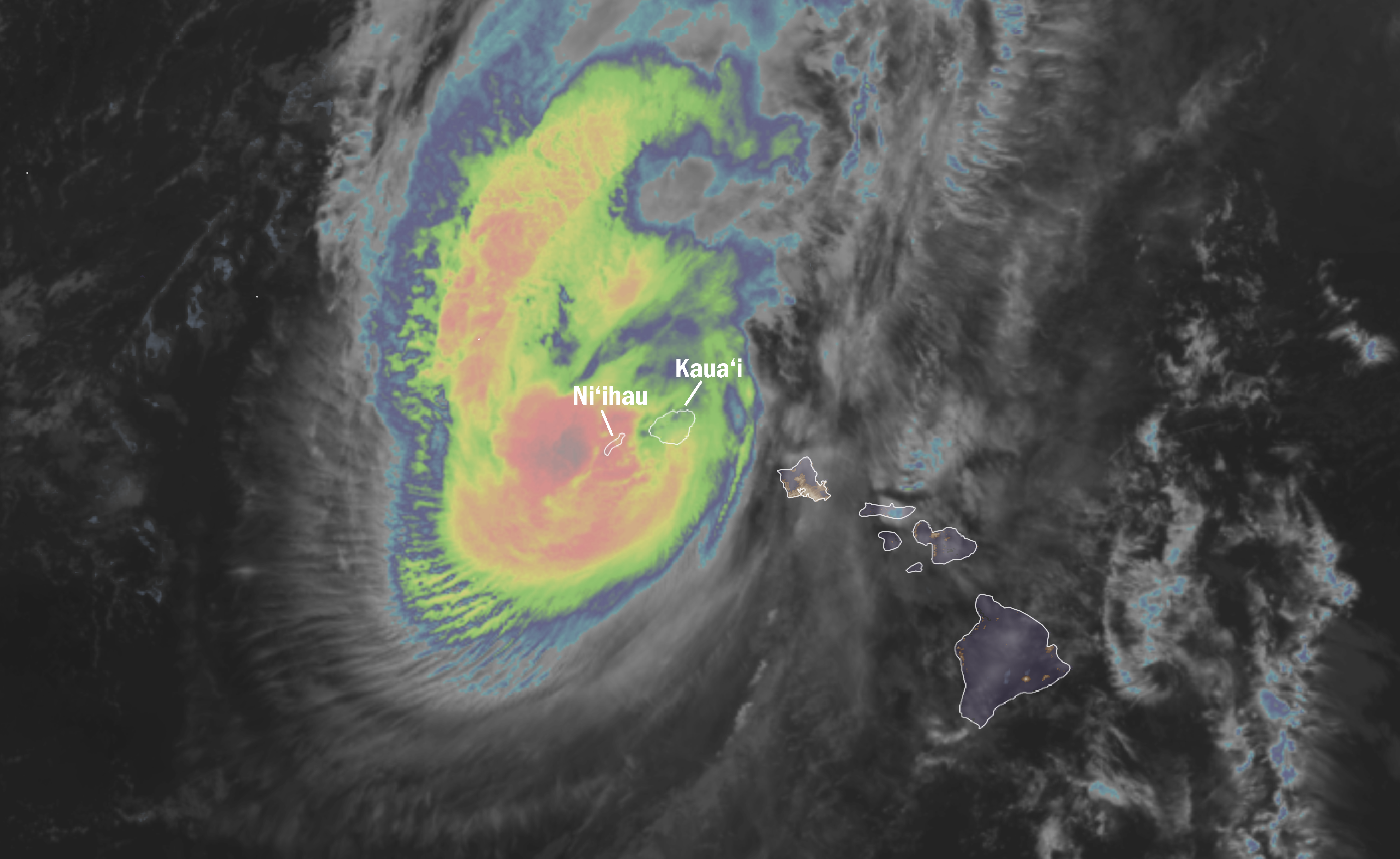
An ongoing disaster we are dealing with is Hurricane Lowell, which has been impacting the Hawaiian Islands the last 24 to 36 hours. Unfortunately, the FAA NEXRAD weather radar on the south shore of Kauai was inoperative during the final approach of the hurricane, but satellite and radars from longer distance imply that the center of Lowell passed just to the west of the island of Ni’ihau. Winds gusted over 90 mph on Kaua’i and extensive wind and flooding damage appears to have occurred — nearly the entire island is without power this morning. My colleague Michael Lowry has an excellent summary of what has transpired in the last day or so with Lowell that I encourage you to read here.
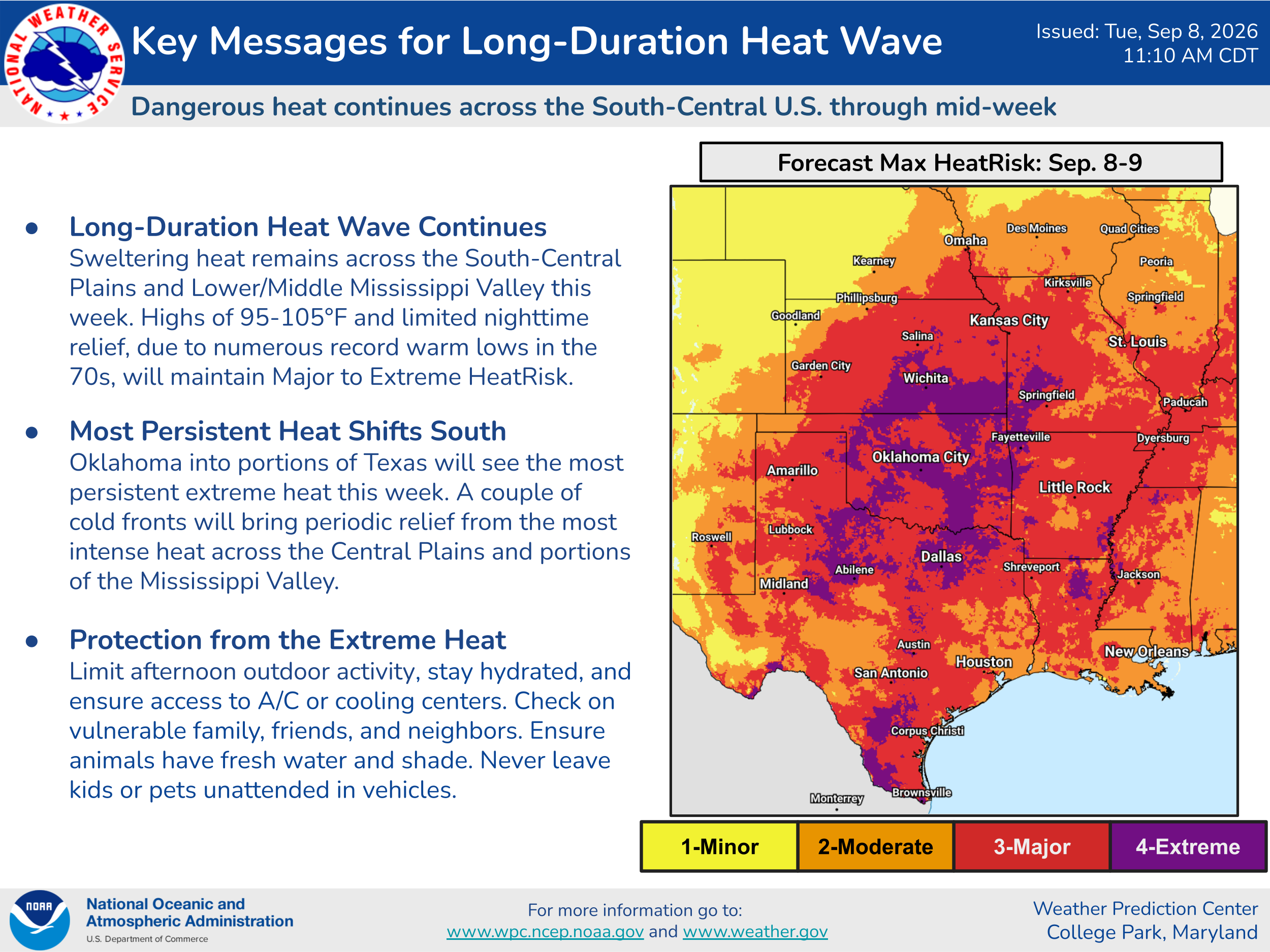
The heat will continue to be a major story for the country this week, with the most intense and prolonged heat continuing to be focused across the south-central United States.
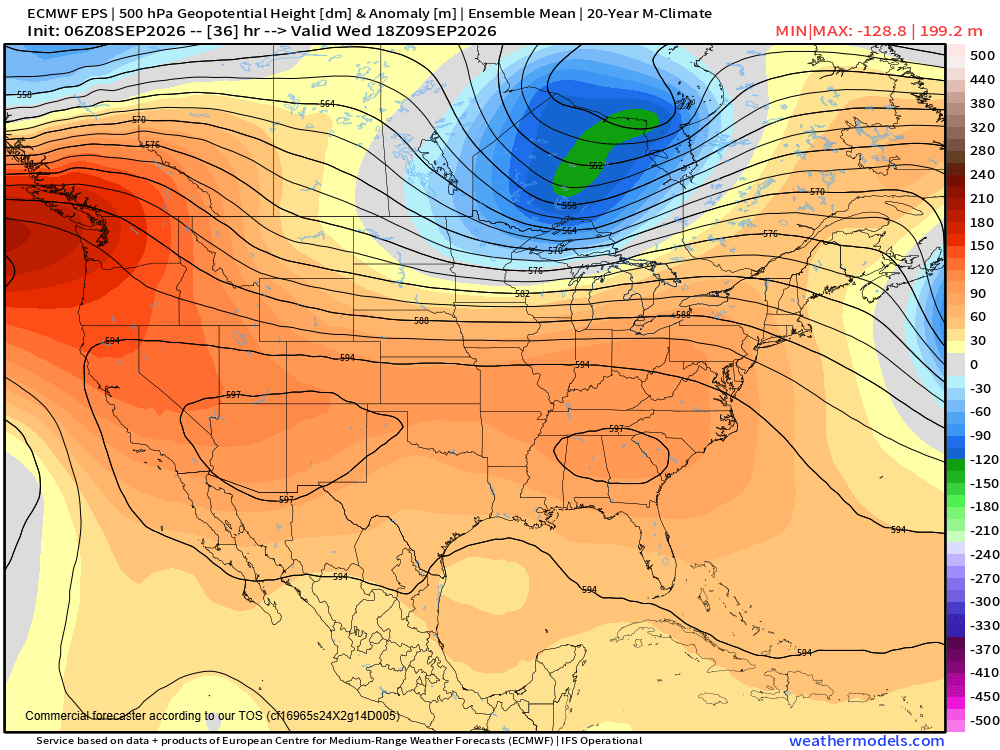
The upper level dome of high pressure responsible for the heat will temporarily build from coast-to-coast over the next 24-36 hours, bringing unusual heat and humidity to both coasts for a few days.
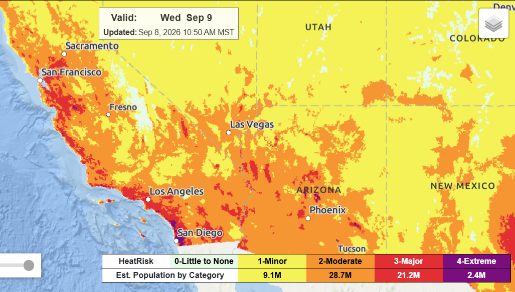
The combined heat and humidity will be particularly unusual along the West Coast. Tropical moisture from the hurricane active eastern Pacific brought rather rare September rainfall to southern California over the weekend and will now be responsible for high humidity as heat builds across the region. Major to extreme heat risk is expected even in coastal locations of California on Wednesday.


Leave a Reply