
IT, communications and radar are all concerns for the weather community
I want to start off today by highlighting a developing story about the national air traffic control (ATC) system. ATC equipment issues in the Northeast — apparently due to radio issues with the FAA’s Traffic Control facility in Philadelphia — have been causing ground stops and increasing delays. These issues come as the UK is dealing with its second serious ATC network issue this month, and amid increasing scrutiny of the aging US ATC infrastructure.
Last week, the Government Accountability Office (GAO) released a new report summarizing their investigation of the FAA’s efforts to modernize the ATC system:
The Federal Aviation Administration has struggled for decades to modernize its outdated air traffic control systems, which are critical for safe and efficient flight operations. In May 2025, it launched an initiative to accelerate these efforts. FAA has made progress implementing this initiative, but it could be prioritizing speed over costs and air traffic disruptions. For example, FAA doesn’t have a lifecycle cost estimate or master schedule for related projects. Without them, the agency could end up causing air traffic disruptions or prolonging reliance on severely outdated systems.
The GAO report outlines a number of recommendations for the FAA’s modernization effort:
The Federal Aviation Administration’s (FAA) Brand New Air Traffic Control System (BNATCS) has an ambitious goal to significantly accelerate the modernization of outdated air traffic control (ATC) systems. The goal is to be achieved at an unprecedented speed. The first of two phases aims to modernize communication, surveillance, weather, and training systems, among other things. For example, FAA plans to modernize voice radio systems 9 years earlier than initially planned. Phase 1 is to be fully completed by December 2028. In July 2025, Congress appropriated $12.5 billion to support BNATCS and FAA is using most of the funds for phase 1. For phase 2, FAA plans to develop new automation systems to track aircraft and optimize traffic. FAA stated that they will need approximately $10.2 billion for this phase (not including facilities). FAA does not yet have an estimated date for when phase 2 will be started or completed.
These FAA issues have strong parallels with the situation facing the NWS and its need to modernize its own infrastructure. In recent weeks, IT and communications issues have resulted in national network outages that have prevented severe weather warnings from being disseminated in a timely manner. The primary national computing system NWS relies on for operations — known as AWIPS — was initially developed and deployed in the 1990s.
NWS is currently in the process of implementing the HIVE and CIRRUS projects that will replace AWIPS, and as GAO reported with the FAA and BNATCS, the NWS is pursuing an unprecedented timeline for these efforts, with Phase 1 scheduled for early 2027 and Phase 2 — which includes decommissioning of the old AWIPS system and complete transition to HIVE and CIRRUS — targeted for early 2028.
While it remains to be seen if these target dates will be reached, at least the NWS has a plan and ongoing process to pursue this modernization. Another critical piece of aging weather technology is the nation’s weather radar network, known as NEXRAD. NEXRAD is actually not strictly a National Weather Service program, but rather is a tri-agency network with NWS as lead agency but the FAA and DOD as partner agencies. While NEXRAD has undergone many updates over the years, similar to AWIPS this system was developed and deployed in the 1980s and 1990s.
The NWS has a new program known as Radar Next to develop a modernized, next generation weather radar network. This program has been spinning up aggressively in the last year or so, with the NWS issuing calls for information and holding its first industry day this summer to obtain input from private sector contractors and partners who could have potential involvement in a new national radar network.
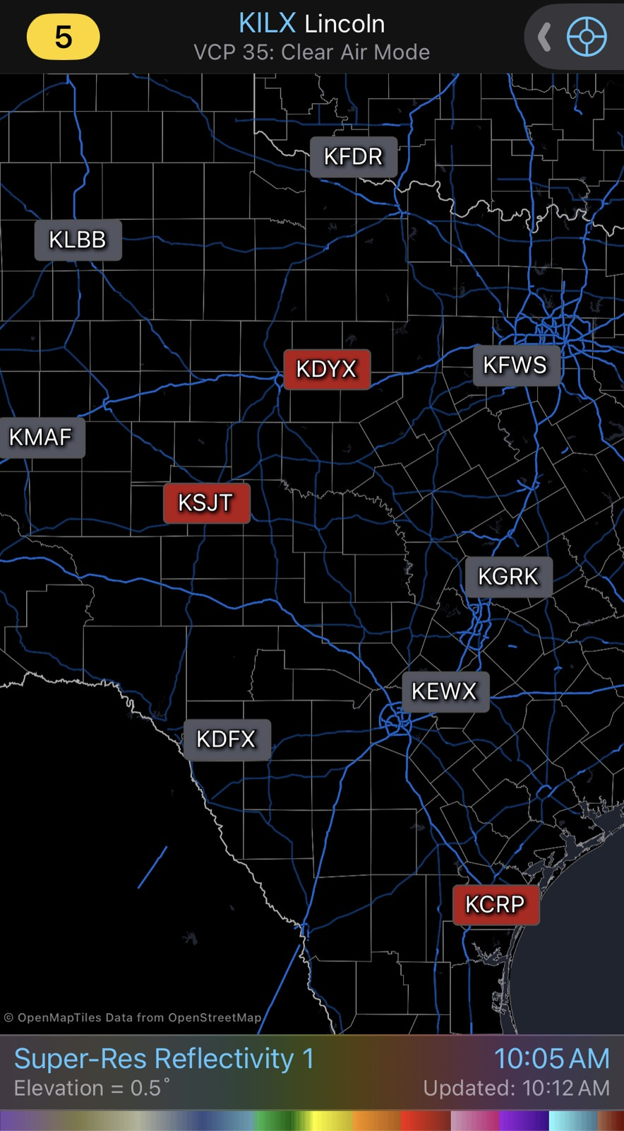
It is exciting to see Radar Next starting to gain traction — but I remain extremely concerned about the state of our current Doppler weather radar network and its future. Above is a screen grab from RadarScope this morning, showing that three radars were not providing data. Obviously I am not sure why these particular radars were inoperable, but I am showing this more to indicate how vulnerable weather services are to radar outages. We have very little redundancy in the radar network. Losing one radar like Corpus Christi can cause a serious lack of radar data around that area — when two adjacent radars are down like the San Angelo and Dyess AFB radars in central Texas are, there is a major gap in data.
NWS Doppler weather radar data is truly irreplaceable for life-saving warnings for hazards such as tornadoes, severe thunderstorms and flash floods. Without it, meteorologists are pretty much “flying blind” when it comes to proactive warnings ahead of these dangerous weather events.
And to be clear, it is not just NWS meteorologists who are left blind. While there are increasing efforts in the private and academic sectors to install weather radars — and these radar systems are being counted on by the NWS to be a part of the next generation weather radar network — NEXRAD is still the core foundational weather radar system for the United States. It is critical for not only weather forecasts and warnings, but for our society in general — everything from a safe transportation system to knowing when one can go out for a run rely upon our weather radar network.
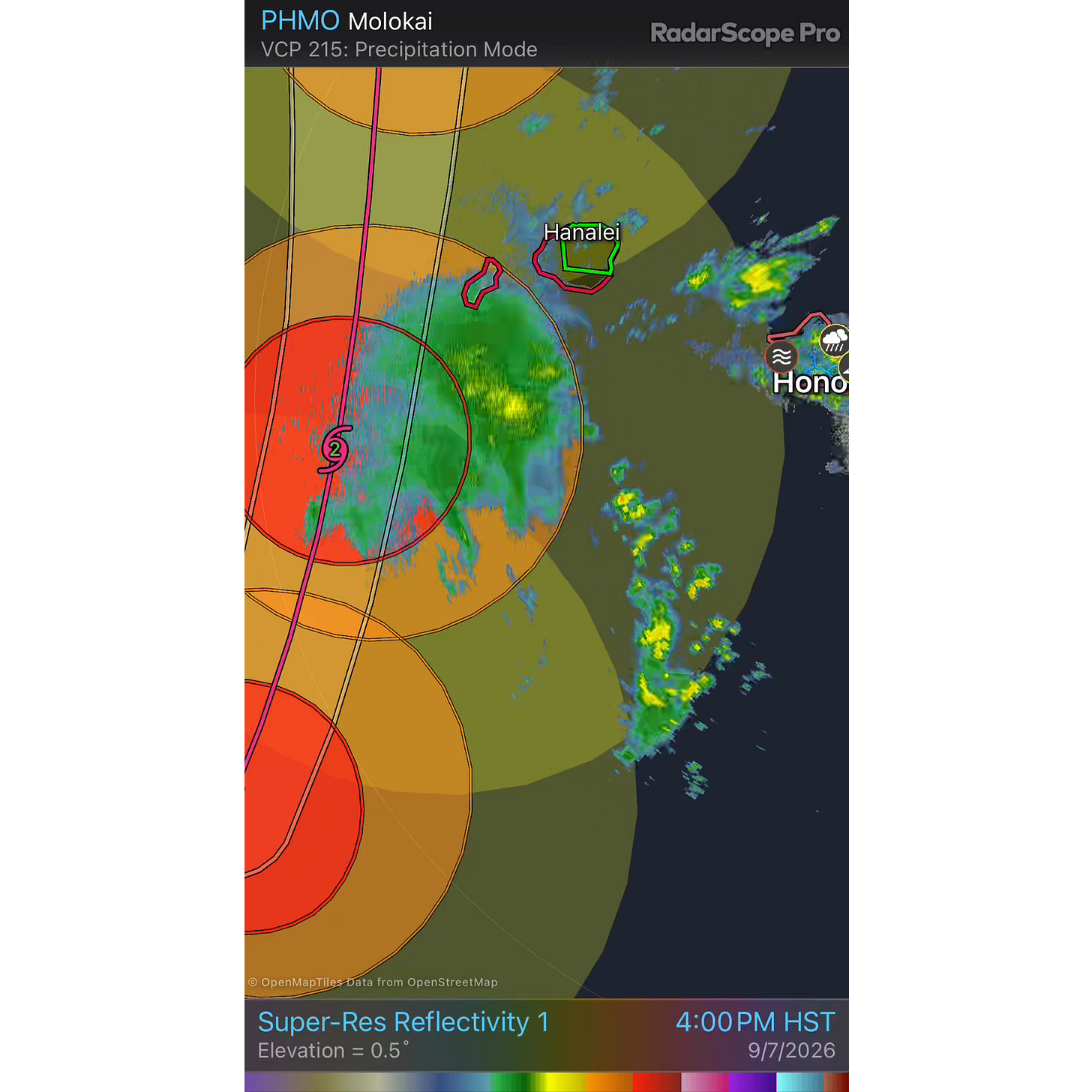
We saw an example of how just one radar being down can be a critical problem just a couple of weeks ago when the Kauai radar was down during the passage of Hurricane Lowell through the region. Without that radar, meteorologists had to rely on the next closest radar on Molokai.
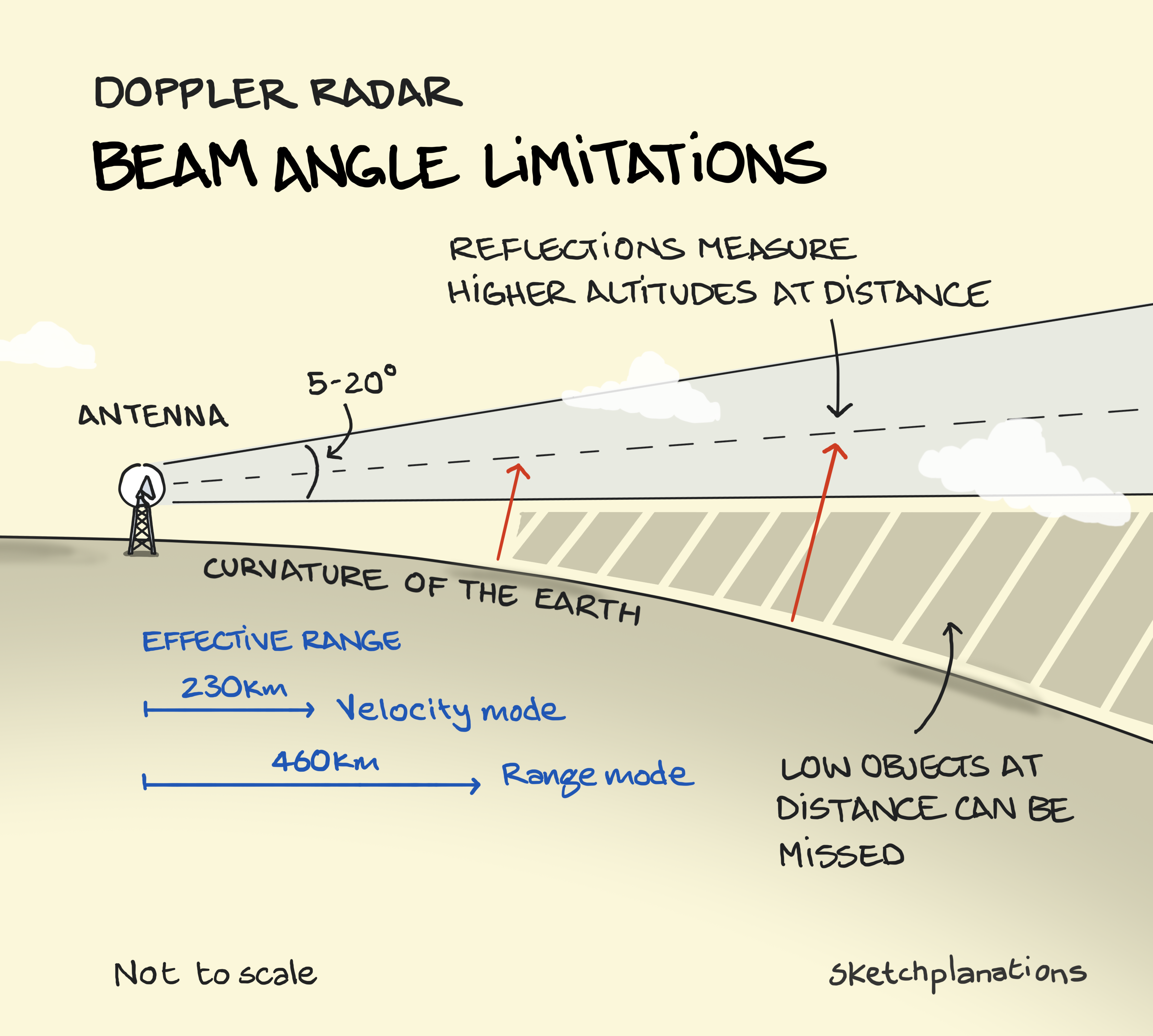
Radar data from as close to the surface of the Earth as possible is crucial, and because of the curvature of the Earth, the farther a radar is from a point, the higher it is observing in the atmosphere. In the case of Lowell and Kauai, the radar outage meant that low level radar data was lost — critical data for monitoring the evolution of the eyewall, monitoring potential tornadic circulations within rainbands, and low level data crucial for accurate rainfall estimates in support of flash flood warnings and forecasts.
While it is difficult for those of us external to NOAA/NWS to know the exact state of the NEXRAD network today, we do know that a number of longtime electronics technicians who had critical experience on maintaining these aging systems left during the OMB/DOGE reductions of the last couple of years. We also know that NWS studies in support of Radar Next that have been reported on at scientific conferences project increasing outages and risks for longer term outages as the systems continue to age and replacement parts become more difficult to obtain.
As one of the NWS leaders alluded to at their Radar Next industry day presentation, this is truly a worrisome situation:
While people see radar-based alerts on the evening news, they might not know there is a risk, (NWS Observations director Ajay) Mehta told FedScoop. Roughly 90% of severe weather warnings are generated by radar data. “These radars are aging, and they are so critical,” he said. A Senate bill reauthorizing the Weather Act, a comprehensive law aimed at improving weather research and technology, would direct the agency to deploy Radar Next by late 2040. However, during his presentation, Mehta told the audience that the deadline might be moved up in subsequent drafts as a result of the push to accelerate the work.
I do not think there is any question that if the full implementation of a new weather radar network does not happen before 2040 that there will be serious repercussions for a society that is only growing more reliant upon accurate weather information. Political leadership and the public and private sectors have to work together to try to accelerate the modernization of this crucial national resource.
I will have some info about ongoing weather — including the Monday tropical update — via a post or video sometime later today or tonight.
 Balanced Weather
Leave a comment